


$770
/ Month
5854 W Pameleen Ct Unit 5854-11
Cincinnati, OH 45239
2 Weeks Ago
|
Edit
Favorites
5854 W Pameleen Ct Unit 5854-11

Favorites
Check Back Soon for Upcoming Availability
| Beds | Baths | Average SF |
|---|---|---|
| 2 Bedrooms 2 Bedrooms 2 Br | 1.5 Baths 1.5 Baths 1.5 Ba | 800 SF |
About This Property
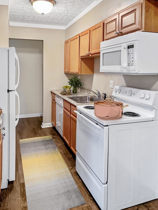
SNS Management is proud to present the Groesbeck Gardens Apartments! With 33 spacious 2 bedroom, 1.5 bathroom apartments set back from a quiet dead-end residential street, you get the peacefulness of a smaller complex with the comforts of professional property management. Convenient to I-275 and Ronald Reagan Highway, grocery stores, restaurants, and retail. You will enjoy the freshly updated apartments, which include beautifully refinished hardwood floors, and a half-bath off the master bedroom. The open-concept apartment includes a living room, dining area, and kitchen with all major appliances including dishwasher. Coin-operated laundry and extra storage space is available in each building. The landlord provides heat and trash, while residents are responsible for electric and a $30 monthly fee for water. Sorry, we do not accept pets or Section 8 and have a non-smoking policy. Application fees are $30 per person 18 or older. Below are the minimum requirements for the property: - Credit Score: 550 average among applicants (check yours for free at creditkarma.com) - Income: Gross income 3x the monthly rent - Criminal: No sex offenders, No violent felonies ever, No non-violent felonies past 7 years - Evictions: No evictions in past 7 years. This apartment is professionally managed by SNS Management LLC. We strive to simplify the entire rental process from start to finish, while also providing a safe, quiet environment for our residents. You can even conveniently pay your rent and submit maintenance requests right from your smart phone! To apply or see other available properties, please visit our website at https://www.sns-management.com/.
5854 W Pameleen Ct is an apartment community located in Hamilton County and the 45239 ZIP Code.
Features
- Laundry Facilities
- Storage Space
5854 W Pameleen Ct,
Cincinnati,
OH
45239
Mount Airy is a classic suburban neighborhood with peaceful streets lined with single-family homes. Interstate 74 and Highway 22 makes the seven mile drive into Downtown Cincinnati and beyond accessible, but Mount Airy has a lot to offer from within. Its southern border encompasses Mount Airy Forest, which provides residents with outdoor fun. There are also a few fast food restaurants within the neighborhood, but residents can easily travel to the surrounding areas or into downtown for a diverse selection of restaurants. Renters will find that they have a few affordable options of apartments in longstanding brick buildings to choose from.
Learn more about living in Mount AiryBelow are rent ranges for similar nearby apartments
Amenities
- Laundry Facilities
- Storage Space
Education
| Colleges & Universities | Distance | ||
|---|---|---|---|
| Colleges & Universities | Distance | ||
| Drive: | 16 min | 6.0 mi | |
| Drive: | 17 min | 7.6 mi | |
| Drive: | 19 min | 8.1 mi | |
| Drive: | 23 min | 9.6 mi |
5854 W Pameleen Ct Unit 5854-11 is within 16 minutes or 6.0 miles from Cincinnati State. It is also near University of Cincinnati and Univ. of Cincinnati, Medical.
Transportation options available in Cincinnati include Brewery District Station - Elm & Henry, located 8.3 miles from 5854 W Pameleen Ct Unit 5854-11. 5854 W Pameleen Ct Unit 5854-11 is near Cincinnati/Northern Kentucky International, located 22.3 miles or 42 minutes away.
| Transit / Subway | Distance | ||
|---|---|---|---|
| Transit / Subway | Distance | ||
| Drive: | 18 min | 8.3 mi | |
| Drive: | 18 min | 8.4 mi | |
| Drive: | 19 min | 8.5 mi | |
| Drive: | 19 min | 8.5 mi | |
| Drive: | 19 min | 8.7 mi |
| Commuter Rail | Distance | ||
|---|---|---|---|
| Commuter Rail | Distance | ||
|
|
Drive: | 18 min | 8.3 mi |
| Airports | Distance | ||
|---|---|---|---|
| Airports | Distance | ||
|
Cincinnati/Northern Kentucky International
|
Drive: | 42 min | 22.3 mi |
Walkability Near 5854 W Pameleen Ct Cincinnati, OH 45239
Getting Around
 What do Walkability, Transit, Drivability, and Bikeability mean?
Walkability measures the walking distance to day-to-day needs.
Transit measures access to public transportation.
Drivability measures congestion, parking availability, and access to major roads.
Bikeability measures the suitability for cycling.
How It Works
What do Walkability, Transit, Drivability, and Bikeability mean?
Walkability measures the walking distance to day-to-day needs.
Transit measures access to public transportation.
Drivability measures congestion, parking availability, and access to major roads.
Bikeability measures the suitability for cycling.
How It Works
Fairly Walkable
Walkability
40
/ 100
Limited Public Transit
Transit
20
/ 100
Very Drivable
Drivability
80
/ 100
Fairly Bikeable
Bikeability
40
/ 100
Scores provided by
-
Soundscore™
-
/ 100
Traffic
-Airport
-Businesses
-Scores provided by
HowLoud What is a Sound Score Rating? A Sound Score Rating aggregates noise caused by vehicle traffic, airplane traffic and local sources. How It WorksTime and distance from 5854 W Pameleen Ct Unit 5854-11.
| Shopping Centers | Distance | ||
|---|---|---|---|
| Shopping Centers | Distance | ||
| Walk: | 10 min | 0.5 mi | |
| Walk: | 11 min | 0.6 mi | |
| Drive: | 4 min | 1.4 mi |
5854 W Pameleen Ct Unit 5854-11 has 3 shopping centers within 1.4 miles, which is about a 4-minute drive. The miles and minutes will be for the farthest away property.
| Parks and Recreation | Distance | ||
|---|---|---|---|
| Parks and Recreation | Distance | ||
|
Farbach-Werner Nature Preserve
|
Drive: | 7 min | 2.7 mi |
|
LaBoiteaux Woods
|
Drive: | 8 min | 2.8 mi |
|
Mt. Airy Forest
|
Drive: | 9 min | 3.3 mi |
|
Buttercup Valley
|
Drive: | 10 min | 3.9 mi |
|
Caldwell Preserve
|
Drive: | 13 min | 5.5 mi |
5854 W Pameleen Ct Unit 5854-11 has 5 parks within 5.5 miles, including Farbach-Werner Nature Preserve, LaBoiteaux Woods, and Mt. Airy Forest.
| Hospitals | Distance | ||
|---|---|---|---|
| Hospitals | Distance | ||
| Drive: | 11 min | 4.1 mi | |
| Drive: | 16 min | 6.9 mi | |
| Drive: | 15 min | 9.6 mi |
5854 W Pameleen Ct Unit 5854-11 has 3 hospitals within 9.6 miles, the nearest is Mercy Health - West Hospital which is 4.1 miles away and a 11 minute drive.
| Military Bases | Distance | ||
|---|---|---|---|
| Military Bases | Distance | ||
| Drive: | 70 min | 53.9 mi | |
| Drive: | 76 min | 58.9 mi | |
| Drive: | 79 min | 62.2 mi |
5854 W Pameleen Ct Unit 5854-11 has 3 military bases within 62.2 miles, the nearest is Gentile Air Force Station which is 53.9 miles away and a 70 minute drive.
You May Also Like
Similar Rentals Nearby
-
-
-
-
-
-
-
-
-
-
2 Beds$2,039+Total Monthly PriceTotal Monthly Price NewPrices include all required monthly fees.1 Month Free
Pets Allowed Pool In Unit Washer & Dryer Clubhouse Maintenance on site Stainless Steel Appliances


What Are Walk Score®, Transit Score®, and Bike Score® Ratings?
Walk Score® measures the walkability of any address. Transit Score® measures access to public transit. Bike Score® measures the bikeability of any address.
What is a Sound Score Rating?
A Sound Score Rating aggregates noise caused by vehicle traffic, airplane traffic and local sources.

5854 W Pameleen Ct
Cincinnati, OH 45239