
Presidential Towers
555 W Madison St,
Chicago, IL 60661
$1,793 - $5,054
Studio - 2 Beds
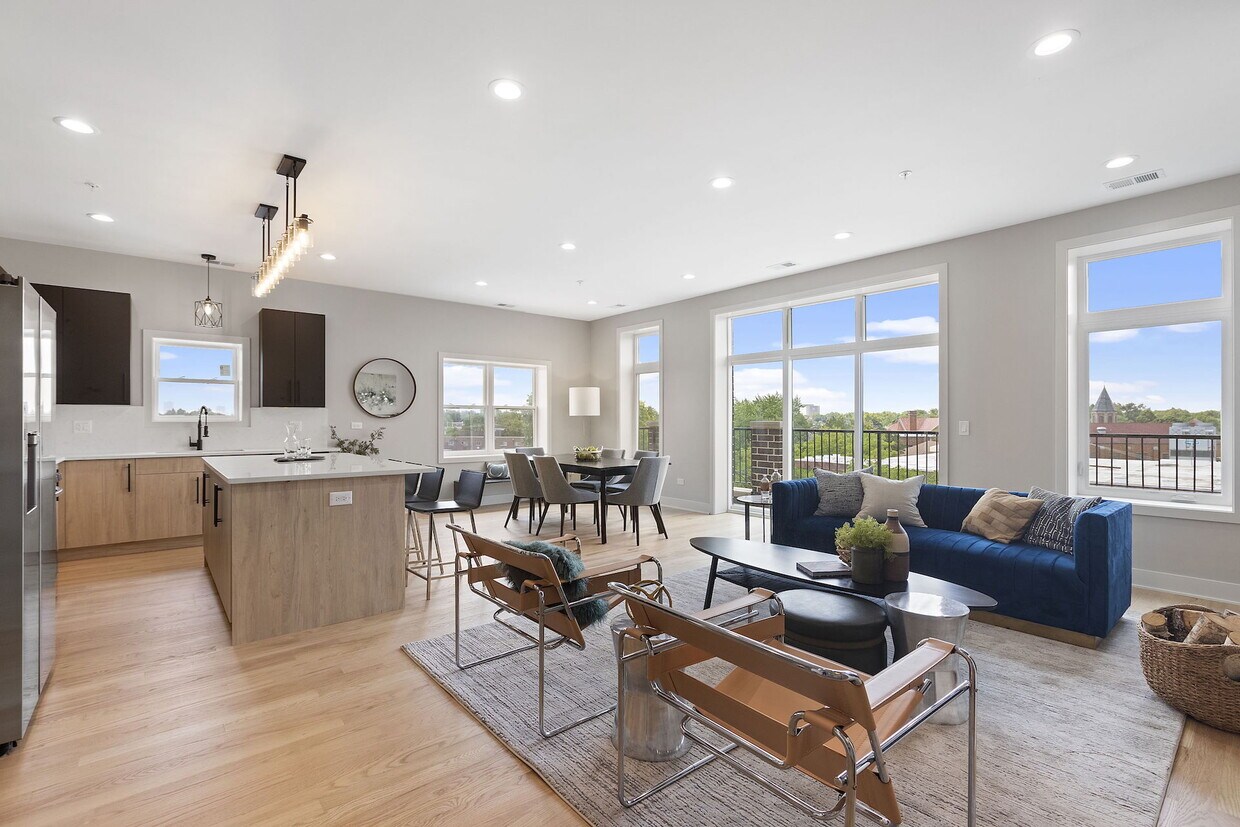

Welcome to luxury living at an unbeatable value on Chicago's north side! This exceptional new construction apartment offers a lavish 3 Bedrooms + Den layout with 2.5 Bathrooms and the convenience of an In-Unit Washer/Dryer and a Garage Parking space Included! Large windows and an open-concept design create a bright and airy atmosphere. This beautifully appointed home boasts high-end finishes, including a large chef-inspired kitchen with an island, stainless steel appliances, and gorgeous bathrooms. Schedule a showing today to take advantage of the opportunity to make this stunning new construction apartment your home.
5689 N Lincoln Ave is an apartment community located in Cook County and the 60659 ZIP Code. This area is served by the Chicago Public Schools attendance zone.
Unique Features
Washer/Dryer
Air Conditioning
Dishwasher
Hardwood Floors
Walk-In Closets
Island Kitchen
Microwave
Refrigerator
West Ridge Park is located on the far north side of Chicago, an upscale community encompassed with tree-lined streets, multicultural establishments, and historic homes.
Many diverse restaurants can be found along West Devon Avenue, which is a couple of blocks south of Robert A. Black Golf Course. Many green spaces make up West Rogers Park, including Mather Park and Indian Boundary Park.
Residents of this lush Chicago community enjoy proximity to Rogers Park Train Station, Loyola Beach, and Lincoln Town Center mall.
Learn more about living in West Rogers ParkCompare neighborhood and city base rent averages by bedroom.
| West Rogers Park | Chicago, IL | |
|---|---|---|
| Studio | $981 | $1,632 |
| 1 Bedroom | $1,138 | $2,028 |
| 2 Bedrooms | $1,411 | $2,545 |
| 3 Bedrooms | $1,840 | $3,058 |
| Colleges & Universities | Distance | ||
|---|---|---|---|
| Colleges & Universities | Distance | ||
| Drive: | 4 min | 1.5 mi | |
| Drive: | 3 min | 1.5 mi | |
| Drive: | 7 min | 3.2 mi | |
| Drive: | 7 min | 3.3 mi |


Transportation options available in Chicago include Western Station (Brown Line), located 1.6 miles from 5689 N Lincoln Ave. 5689 N Lincoln Ave is near Chicago O'Hare International, located 12.1 miles or 21 minutes away, and Chicago Midway International, located 15.9 miles or 30 minutes away.
| Transit / Subway | Distance | ||
|---|---|---|---|
| Transit / Subway | Distance | ||
|
|
Drive: | 3 min | 1.6 mi |
|
|
Drive: | 3 min | 1.9 mi |
|
|
Drive: | 5 min | 2.0 mi |
|
|
Drive: | 4 min | 2.1 mi |
|
|
Drive: | 5 min | 2.2 mi |
| Commuter Rail | Distance | ||
|---|---|---|---|
| Commuter Rail | Distance | ||
| Drive: | 3 min | 1.7 mi | |
|
|
Drive: | 6 min | 2.6 mi |
|
|
Drive: | 7 min | 3.3 mi |
|
|
Drive: | 7 min | 4.1 mi |
|
|
Drive: | 7 min | 4.2 mi |
| Airports | Distance | ||
|---|---|---|---|
| Airports | Distance | ||
|
Chicago O'Hare International
|
Drive: | 21 min | 12.1 mi |
|
Chicago Midway International
|
Drive: | 30 min | 15.9 mi |
Scores provided by
Traffic
-Airport
-Businesses
-Scores provided by
HowLoud What is a Sound Score Rating? A Sound Score Rating aggregates noise caused by vehicle traffic, airplane traffic and local sources. How It WorksTime and distance from 5689 N Lincoln Ave.
| Shopping Centers | Distance | ||
|---|---|---|---|
| Shopping Centers | Distance | ||
| Walk: | 7 min | 0.4 mi | |
| Walk: | 11 min | 0.6 mi | |
| Walk: | 22 min | 1.2 mi |
| Parks and Recreation | Distance | ||
|---|---|---|---|
| Parks and Recreation | Distance | ||
|
Winnemac Park
|
Drive: | 3 min | 1.4 mi |
|
Warren Park
|
Drive: | 3 min | 1.8 mi |
|
North Park Village Nature Center
|
Drive: | 3 min | 2.0 mi |
|
Chase Park
|
Drive: | 5 min | 2.6 mi |
|
Gompers Park
|
Drive: | 5 min | 2.6 mi |
| Hospitals | Distance | ||
|---|---|---|---|
| Hospitals | Distance | ||
| Walk: | 14 min | 0.7 mi | |
| Drive: | 5 min | 2.1 mi | |
| Drive: | 7 min | 3.5 mi |
| Military Bases | Distance | ||
|---|---|---|---|
| Military Bases | Distance | ||
| Drive: | 29 min | 19.7 mi |
What Are Walk Score®, Transit Score®, and Bike Score® Ratings?
Walk Score® measures the walkability of any address. Transit Score® measures access to public transit. Bike Score® measures the bikeability of any address.
What is a Sound Score Rating?
A Sound Score Rating aggregates noise caused by vehicle traffic, airplane traffic and local sources.

5689 N Lincoln Ave
Chicago, IL 60659


