


$2,295
Total Monthly Price
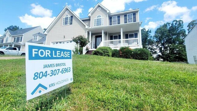
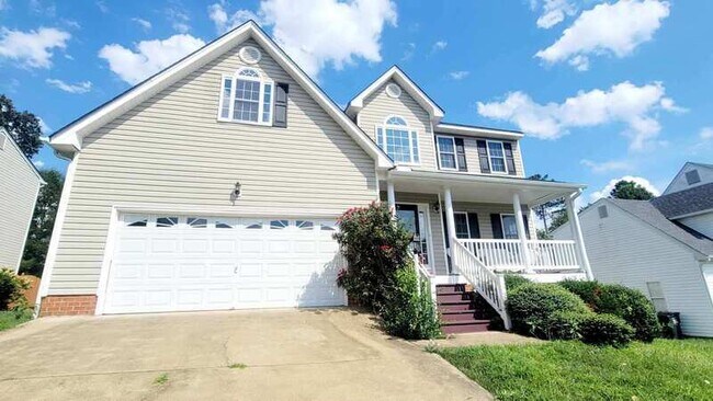
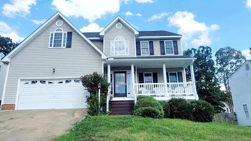
5625 Burnage Ct
Chesterfield, VA 23832
Favorites
5625 Burnage Ct

Favorites
Check Back Soon for Upcoming Availability
| Beds | Baths | Average SF |
|---|---|---|
| 4 Bedrooms 4 Bedrooms 4 Br | 2.5 Baths 2.5 Baths 2.5 Ba | 2,486 SF |
About This Property
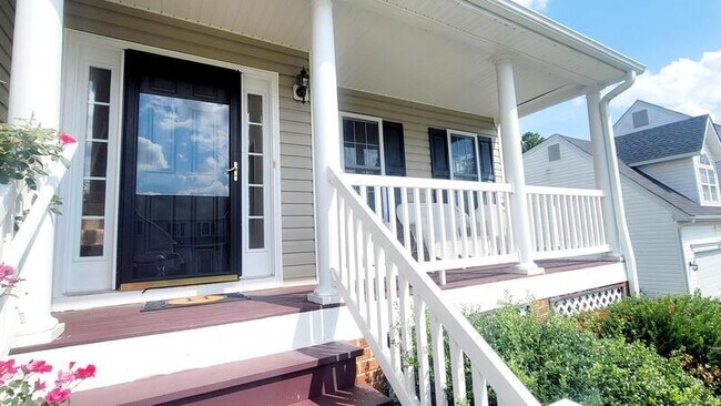
5625 Burnage Ct, Chesterfield, VA 23832 This stunning 4 bedrooms, 2.5 bath home is ready for immediate move-in. It features central heat and air, hardwood floors in the first floor, and carpet on the second floor. The master bedroom boats and attached bathroom with double vanity and a walk-in closet, while the spacious dinning area and eat-in kitchen come complete with a stove, fridge, dishwasher, and microwave. The laundry area includes a washer and dryer, and there is asl a sun room. Plus, the home offers a 2-car garage for added convenience. Stop by our office for more information 418 N 2nd St, Richmond, VA 23219 Apply online at
5625 Burnage Ct is a house located in Chesterfield County and the 23832 ZIP Code. This area is served by the Chesterfield County Public Schools attendance zone.
5625 Burnage Ct,
Chesterfield,
VA
23832
Situated about 15 miles southwest of Richmond, Chesterfield offers residents a peaceful enclave from the bustle of city living. Engulfed in lush natural beauty, Chesterfield is convenient to an array of outdoor activities at Pocahontas State Park, Harry G. Daniel Park at Ironbridge, and a host of nearby lakes and reservoirs.
Chesterfield is known as a historic treasure, with roots dating back to the 17th century. Residents and visitors alike can learn more about Chesterfield’s storied past at the Chesterfield County Museum, Magnolia Grange House Museum, and Henricus Historical Park.
While Chesterfield feels worlds away from big-city congestion, it’s only about a 20-minute drive from the capital city of Richmond. Commuting and traveling from Chesterfield is easy with access to Route 288 and Chesterfield County Airport.
Learn more about living in Chesterfield
Education
| Colleges & Universities | Distance | ||
|---|---|---|---|
| Colleges & Universities | Distance | ||
| Drive: | 20 min | 9.2 mi | |
| Drive: | 21 min | 13.7 mi | |
| Drive: | 27 min | 15.2 mi | |
| Drive: | 26 min | 15.7 mi |
5625 Burnage Ct is within 20 minutes or 9.2 miles from John Tyler C.C., Midlothian. It is also near John Tyler C.C., Chester and University of Richmond.
Schools


Public Elementary School
Grades PK-5
651 Students
Attendance Zone
Public Middle School
Grades 6-8
1,459 Students
Attendance Zone
Public High School
Grades 9-12
2,188 Students
Attendance Zone
Private Elementary, Middle & High School
Grades PK-12
62 Students
Nearby
Private Elementary, Middle & High School
Grades K-12
Nearby
Private Elementary, Middle & High School
Grades PK-12
376 Students
Nearby
School data provided by
 The GreatSchools Rating helps parents compare schools within a state based on a variety of school quality indicators and provides a helpful picture of how effectively each school serves all of its students. Ratings are on a scale of 1 (below average) to 10 (above average) and can include test scores, college readiness, academic progress, advanced courses, equity, discipline and attendance data. We also advise parents to visit schools, consider other information on school performance and programs, and consider family needs as part of the school selection process.
View GreatSchools Rating Methodology
Data provided by GreatSchools.org © 2026. All rights reserved.
View GreatSchools Rating Methodology
Data provided by GreatSchools.org © 2026. All rights reserved.
Walkability Near 5625 Burnage Ct Chesterfield, VA 23832
Getting Around
 What do Walkability, Transit, Drivability, and Bikeability mean?
Walkability measures the walking distance to day-to-day needs.
Transit measures access to public transportation.
Drivability measures congestion, parking availability, and access to major roads.
Bikeability measures the suitability for cycling.
How It Works
What do Walkability, Transit, Drivability, and Bikeability mean?
Walkability measures the walking distance to day-to-day needs.
Transit measures access to public transportation.
Drivability measures congestion, parking availability, and access to major roads.
Bikeability measures the suitability for cycling.
How It Works
Somewhat Walkable
Walkability
20
/ 100
Minimal Public Transit
Transit
0
/ 100
Exceptionally Drivable
Drivability
100
/ 100
Fairly Bikeable
Bikeability
40
/ 100
Scores provided by
-
Soundscore™
-
/ 100
Traffic
-Airport
-Businesses
-Scores provided by
HowLoud What is a Sound Score Rating? A Sound Score Rating aggregates noise caused by vehicle traffic, airplane traffic and local sources. How It WorksYou May Also Like
Similar Rentals Nearby


What Are Walk Score®, Transit Score®, and Bike Score® Ratings?
Walk Score® measures the walkability of any address. Transit Score® measures access to public transit. Bike Score® measures the bikeability of any address.
What is a Sound Score Rating?
A Sound Score Rating aggregates noise caused by vehicle traffic, airplane traffic and local sources.
5625 Burnage Ct
Chesterfield, VA 23832