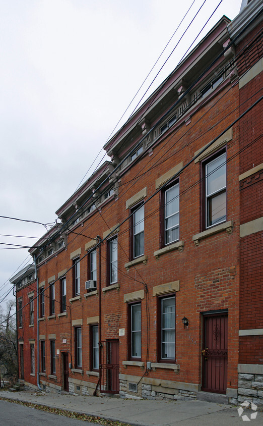
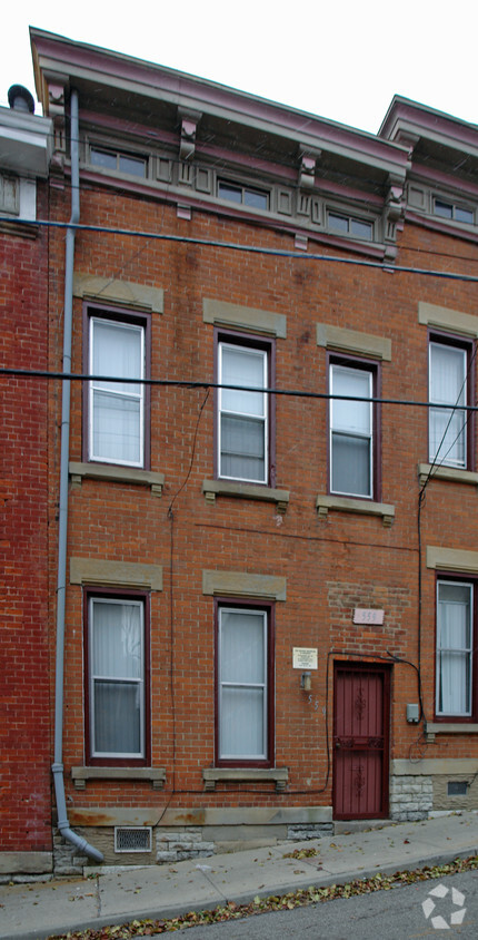
555-559 Boal St
555-559 Boal St,
Cincinnati,
OH
45202
2 Weeks Ago
Favorites
555-559 Boal St
Favorites
Check Back Soon for Upcoming Availability
About 555-559 Boal St Cincinnati, OH 45202
Experience Cincinnati living at 555-559 Boal St. Based in Cincinnati's 45202 area, living here gives you a number of nearby experiences. Make a visit to view the available floorplans. The leasing team is ready to show you our community. Contact us or drop by the leasing office to schedule your tour and find your new home at 555-559 Boal St.
555-559 Boal St is an apartment community located in Hamilton County and the 45202 ZIP Code. This area is served by the Cincinnati Public Schools attendance zone.
Fees and Policies
Details
Property Information
-
6 units/2 stories
Location
Get Directions
The Cincinnati neighborhood of Mount Auburn sits north of downtown and west of Interstate 71. The neighborhood, originally a hilltop escape from the crowded conditions of lower Downtown Cincinnati, gained national recognition as a historic district in 1973. The well-known community contains beautiful mansions dating back to 1819, including the home of former President William Howard Taft.
The community contains beautiful mansions formerly owned by a host of prominent residents. A number of historic buildings and sites dot the area, including the Mount Auburn Young Ladies Institute. The neighborhood also features the beloved ice cream parlor Graeter's Confectionary, as well as Christ Hospital.
Learn more about living in Mount AuburnBelow are rent ranges for similar nearby apartments
| Beds | Average Size | Lowest | Typical | Premium |
|---|---|---|---|---|
| Studio Studio Studio | 530-532 Sq Ft | $800 | $1,356 | $1,869 |
| 1 Bed 1 Bed 1 Bed | 788-790 Sq Ft | $775 | $1,863 | $4,410 |
| 2 Beds 2 Beds 2 Beds | 1148-1152 Sq Ft | $1,080 | $2,634 | $5,685 |
| 3 Beds 3 Beds 3 Beds | 1507-1516 Sq Ft | $1,225 | $3,209 | $5,880 |
| 4 Beds 4 Beds 4 Beds | 2035 Sq Ft | $800 | $3,419 | $27,790 |
Education
| Colleges & Universities | Distance | ||
|---|---|---|---|
| Colleges & Universities | Distance | ||
| Drive: | 6 min | 1.9 mi | |
| Drive: | 6 min | 2.0 mi | |
| Drive: | 10 min | 3.6 mi | |
| Drive: | 12 min | 4.2 mi |
555-559 Boal St is within 6 minutes or 2.0 miles from University of Cincinnati. It is also near Univ. of Cincinnati, Medical and Xavier University.
Schools


Public Elementary, Middle & High School
Grades 5-12
2,582 Students
Attendance Zone
Public Elementary & Middle School
Grades PK-7
348 Students
Attendance Zone
Charter Elementary, Middle & High School
Grades K-12
652 Students
Nearby
Public Middle & High School
Grades 7-12
1,155 Students
Attendance Zone
Private Elementary & Middle School
Grades PK-8
176 Students
Nearby
Private Elementary, Middle & High School
Grades K-12
131 Students
Nearby
School data provided by
 The GreatSchools Rating helps parents compare schools within a state based on a variety of school quality indicators and provides a helpful picture of how effectively each school serves all of its students. Ratings are on a scale of 1 (below average) to 10 (above average) and can include test scores, college readiness, academic progress, advanced courses, equity, discipline and attendance data. We also advise parents to visit schools, consider other information on school performance and programs, and consider family needs as part of the school selection process.
View GreatSchools Rating Methodology
View GreatSchools Rating Methodology
Transportation options available in Cincinnati include Hanke Exchange Station, 12Th & Main, located 0.7 mile from 555-559 Boal St. 555-559 Boal St is near Cincinnati/Northern Kentucky International, located 16.1 miles or 30 minutes away.
| Transit / Subway | Distance | ||
|---|---|---|---|
| Transit / Subway | Distance | ||
| Walk: | 14 min | 0.7 mi | |
| Walk: | 15 min | 0.8 mi | |
| Walk: | 17 min | 0.9 mi | |
| Walk: | 17 min | 0.9 mi | |
| Walk: | 18 min | 0.9 mi |
| Commuter Rail | Distance | ||
|---|---|---|---|
| Commuter Rail | Distance | ||
|
|
Drive: | 7 min | 2.2 mi |
| Airports | Distance | ||
|---|---|---|---|
| Airports | Distance | ||
|
Cincinnati/Northern Kentucky International
|
Drive: | 30 min | 16.1 mi |
Time and distance from 555-559 Boal St.
| Shopping Centers | Distance | ||
|---|---|---|---|
| Shopping Centers | Distance | ||
| Drive: | 5 min | 1.5 mi | |
| Drive: | 5 min | 1.5 mi | |
| Drive: | 5 min | 2.5 mi |
555-559 Boal St has 3 shopping centers within 2.5 miles, which is about a 5-minute drive. The miles and minutes will be for the farthest away property.
| Parks and Recreation | Distance | ||
|---|---|---|---|
| Parks and Recreation | Distance | ||
|
William H. Taft National Historic Site
|
Walk: | 12 min | 0.6 mi |
|
Krohn Conservatory
|
Drive: | 4 min | 1.4 mi |
|
Eden Park
|
Drive: | 4 min | 1.6 mi |
|
Theodore M. Berry Friendship Park
|
Drive: | 5 min | 2.1 mi |
|
Newport Aquarium
|
Drive: | 6 min | 2.4 mi |
555-559 Boal St has 5 parks within 2.4 miles, including William H. Taft National Historic Site, Krohn Conservatory, and Eden Park.
| Hospitals | Distance | ||
|---|---|---|---|
| Hospitals | Distance | ||
| Walk: | 14 min | 0.7 mi | |
| Drive: | 5 min | 1.6 mi | |
| Drive: | 5 min | 1.9 mi |
555-559 Boal St has 3 hospitals within 1.9 miles, the nearest is Christ Hospital which is 0.7 mile away and a 14 minute walk.
| Military Bases | Distance | ||
|---|---|---|---|
| Military Bases | Distance | ||
| Drive: | 73 min | 52.9 mi | |
| Drive: | 79 min | 57.9 mi | |
| Drive: | 81 min | 61.2 mi |
555-559 Boal St has 3 military bases within 61.2 miles, the nearest is Gentile Air Force Station which is 52.9 miles away and a 73 minute drive.
You May Also Like
What neighborhood is the property located in?
555-559 Boal St Cincinnati, OH 45202 is in Mount Auburn in the city of Cincinnati. Here you’ll find three shopping centers within 2.5 miles of the property. Five parks are within 2.4 miles, including William H. Taft National Historic Site, Krohn Conservatory, and Eden Park.
Similar Rentals Nearby


What Are Walk Score®, Transit Score®, and Bike Score® Ratings?
Walk Score® measures the walkability of any address. Transit Score® measures access to public transit. Bike Score® measures the bikeability of any address.
What is a Sound Score Rating?
A Sound Score Rating aggregates noise caused by vehicle traffic, airplane traffic and local sources
Responded To This Review