

$2,150
Total Monthly Price
12 Month Lease
55 Nathan Rd Unit 1
Waltham, MA 02453
1 Day Ago
Favorites
781-250-3887
-
Bedrooms
1
-
Bathrooms
1
-
Square Feet
999 sq ft
-
Available
Available Oct 1
Highlights
- Hardwood Floors
- Yard
- Smoke Free
55 Nathan Rd Unit 1

Favorites
About This Home
12 Month Lease,
$4,300 deposit,
Available Oct 1
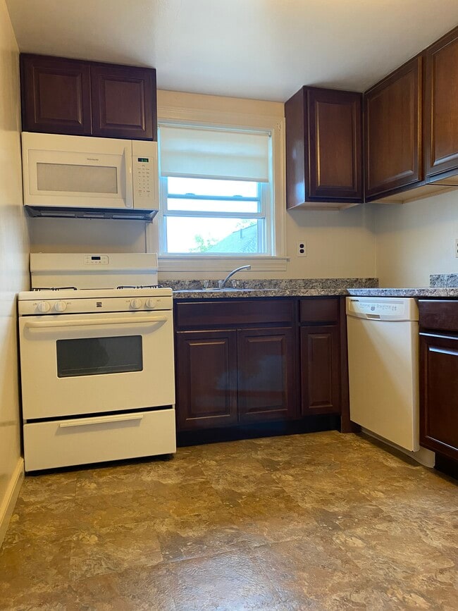
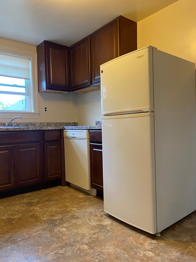
Heat and Hot water included 1 Bedroom, 1 Bathroom Hard wood floors Plenty of closet space back yard Conveniently located minutes from Brandies, Moody St, Waltham Center! Easy access to shops, restaurants, commuter rail to Boston, buses, Mass Pike, Route 128, and I-95. No Broker Fee No smoking No Pets Strong credit, employment verification, rental history, and references required
55 Nathan Rd is an apartment community located in Middlesex County and the 02453 ZIP Code.
* Price shown is total price including community-supplied monthly required fees. Price, availability, fees, and any applicable rent special are subject to change without notice.
* Square footage definitions vary. Displayed square footage is approximate.
Apartment Features
- Smoke Free
- Instant Hot Water
- Hardwood Floors
- Laundry Facilities
- Yard
Fees and Policies
The fees below are based on community-supplied data and may exclude additional fees and utilities.
- Parking
-
Surface Lot--
Details
Utilities Included
-
Water
-
Heat
-
Trash Removal
-
Sewer
Property Information
-
4 units
Contact
- Phone Number
- Contact
Location
Get Directions
Nestled along Interstate 95, Waltham’s West End sits approximately three miles west of the city’s center and 17 miles from Downtown Boston. West End sits on the Cambridge Reservoir, and residents enjoy a variety of rental options, ranging from upscale condos to luxury apartments. The majority of the neighborhood that’s not residential is made up of industrial centers, office buildings, and dense woodlands. Further out from the West End you’ll find stately homes and spacious suburbs. As you near the city, residential streets get busier and there are more big-city amenities to be found.
Learn more about living in West End Waltham
Education
| Colleges & Universities | Distance | ||
|---|---|---|---|
| Colleges & Universities | Distance | ||
| Drive: | 5 min | 1.7 mi | |
| Drive: | 6 min | 2.7 mi | |
| Drive: | 16 min | 6.7 mi | |
| Drive: | 14 min | 7.1 mi |
55 Nathan Rd Unit 1 is within 5 minutes or 1.7 miles from Brandeis University. It is also near Bentley University and Boston College.
Transportation options available in Waltham include Riverside Station, located 3.8 miles from 55 Nathan Rd Unit 1. 55 Nathan Rd Unit 1 is near General Edward Lawrence Logan International, located 15.0 miles or 27 minutes away, and Worcester Regional, located 40.8 miles or 58 minutes away.
| Transit / Subway | Distance | ||
|---|---|---|---|
| Transit / Subway | Distance | ||
|
|
Drive: | 9 min | 3.8 mi |
|
|
Drive: | 9 min | 4.4 mi |
|
|
Drive: | 12 min | 5.7 mi |
|
|
Drive: | 11 min | 6.0 mi |
|
|
Drive: | 13 min | 7.6 mi |
| Commuter Rail | Distance | ||
|---|---|---|---|
| Commuter Rail | Distance | ||
|
|
Drive: | 3 min | 1.3 mi |
| Drive: | 3 min | 1.3 mi | |
|
|
Drive: | 3 min | 1.6 mi |
|
|
Drive: | 3 min | 1.7 mi |
|
|
Drive: | 14 min | 7.9 mi |
| Airports | Distance | ||
|---|---|---|---|
| Airports | Distance | ||
|
General Edward Lawrence Logan International
|
Drive: | 27 min | 15.0 mi |
|
Worcester Regional
|
Drive: | 58 min | 40.8 mi |
Time and distance from 55 Nathan Rd Unit 1.
| Shopping Centers | Distance | ||
|---|---|---|---|
| Shopping Centers | Distance | ||
| Walk: | 3 min | 0.2 mi | |
| Walk: | 15 min | 0.8 mi | |
| Drive: | 3 min | 1.6 mi |
55 Nathan Rd Unit 1 has 3 shopping centers within 1.6 miles, which is about a 3-minute walk. The miles and minutes will be for the farthest away property.
| Parks and Recreation | Distance | ||
|---|---|---|---|
| Parks and Recreation | Distance | ||
|
Land's Sake Farm
|
Drive: | 6 min | 3.1 mi |
|
Beaver Brook Reservation
|
Drive: | 6 min | 3.3 mi |
|
Mass Audubon's Habitat Education Center and Wildlife Sanctuary
|
Drive: | 11 min | 5.2 mi |
|
Mass Audubon's Drumlin Farm Wildlife Sanctuary
|
Drive: | 9 min | 5.2 mi |
|
Hemlock Gorge Reservation
|
Drive: | 13 min | 7.4 mi |
55 Nathan Rd Unit 1 has 5 parks within 7.4 miles, including Land's Sake Farm, Beaver Brook Reservation, and Mass Audubon's Habitat Education Center and Wildlife Sanctuary.
| Hospitals | Distance | ||
|---|---|---|---|
| Hospitals | Distance | ||
| Walk: | 13 min | 0.7 mi | |
| Drive: | 7 min | 3.8 mi | |
| Drive: | 8 min | 5.1 mi |
55 Nathan Rd Unit 1 has 3 hospitals within 5.1 miles, the nearest is Walden Behavioral Care which is 0.7 mile away and a 13 minute walk.
| Military Bases | Distance | ||
|---|---|---|---|
| Military Bases | Distance | ||
| Drive: | 16 min | 8.1 mi | |
| Drive: | 19 min | 10.9 mi |
55 Nathan Rd Unit 1 is 8.1 miles from Hanscom Air Force Base, and is convenient to other military bases, including US Military Reservation.
Amenities
- Smoke Free
- Instant Hot Water
- Hardwood Floors
- Laundry Facilities
- Yard
55 Nathan Rd Unit 1 Photos
What Are Walk Score®, Transit Score®, and Bike Score® Ratings?
Walk Score® measures the walkability of any address. Transit Score® measures access to public transit. Bike Score® measures the bikeability of any address.
What is a Sound Score Rating?
A Sound Score Rating aggregates noise caused by vehicle traffic, airplane traffic and local sources

55 Nathan Rd
Waltham, MA 02453