
$2,500
/ Month
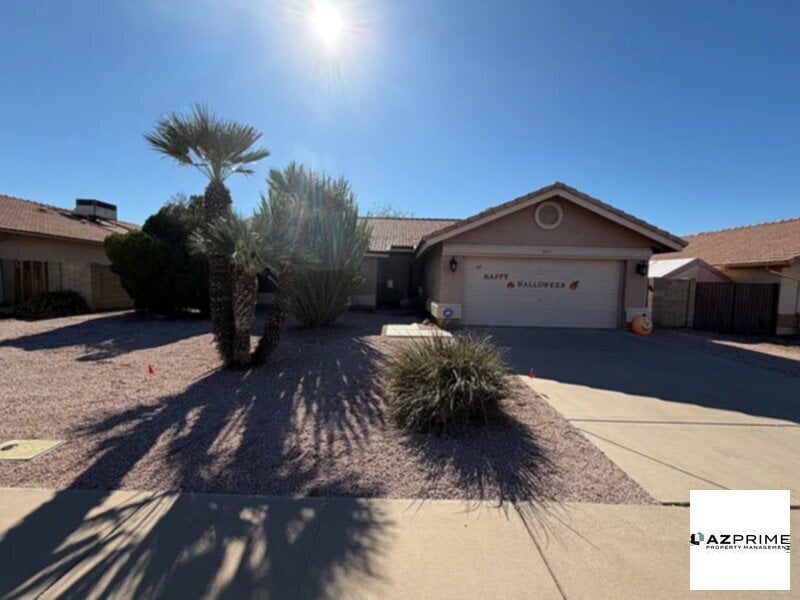
5453 E Emerald Ave
Mesa, AZ 85206
Today
|
Edit
Favorites
480-449-6632
-
Bedrooms
3
-
Bathrooms
2
-
Square Feet
1,506 sq ft
-
Available
Available Now
5453 E Emerald Ave

Favorites
About This Home
Available Now
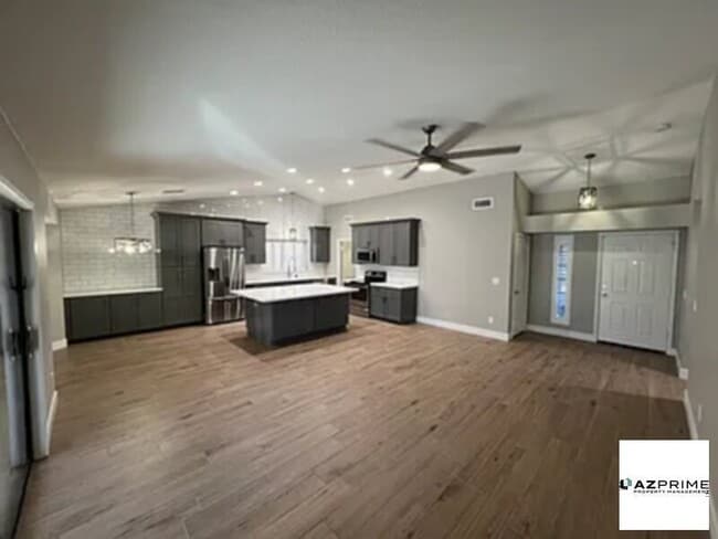
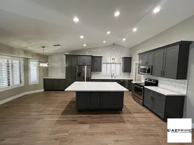
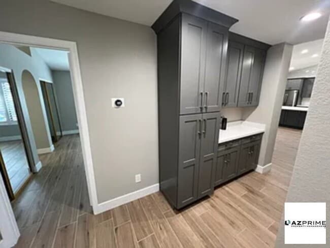
Welcome Home! This home has been fully remodeled home top to bottom in 2024! Open concept kitchen/family room, tile throughout, 2 car garage, Tesla charger, pool has a heater/cooler installed, whole home water filtration system with water softener, high end quartz countertops, cabinets, wood shutters throughout whole home. Close to shopping, restaurants, US 60 and 202 loop north. Quiet street in neighborhood, and within walking distance to a beautiful park!
5453 E Emerald Ave is a house located in Maricopa County and the 85206 ZIP Code. This area is served by the Mesa Unified attendance zone.
* Price shown is base rent. Excludes user-selected optional fees and variable or usage-based fees and required charges due at or prior to move-in or at move-out. Price, availability, fees, and any applicable rent special are subject to change without notice.
* Square footage definitions vary. Displayed square footage is approximate.
Contact
- Listed by AZ Prime Property Management
- Phone Number
- Contact
Location
Get Directions
North of the Phoenix Mesa Gateway Airport is Superstition Springs, a community just 20 minutes outside of Mesa. The north section of the neighborhood boasts an expansive variety of shops and dining establishments.
The Superstition Springs Center mall is a major fashion hub, surrounded by Burlington, Target, and WinCo Foods market. Restaurants in the area include Olive Garden, The Cheesecake Factory, and BJ’s Restaurant and Brewhouse. The mall itself houses its own food court, along with an outdoor amphitheater and movie theater. Residents enjoy the convenience of being close to Mesa, Scottsdale, and Phoenix. Golfers will appreciate the championship golf course at the Superstition Springs Golf Club off Baseline Road.
Learn more about living in Superstition Springs
Education
| Colleges & Universities | Distance | ||
|---|---|---|---|
| Colleges & Universities | Distance | ||
| Drive: | 7 min | 2.8 mi | |
| Drive: | 12 min | 6.3 mi | |
| Drive: | 17 min | 8.6 mi | |
| Drive: | 14 min | 9.1 mi |
5453 E Emerald Ave is within 7 minutes or 2.8 miles from A.T. Still Univ. AZ. It is also near Mesa C.C., Red Mountain Campus and Benedictine University.
Schools


Public Elementary School
Grades PK-6
393 Students
Attendance Zone
Public Middle School
Grades 7-8
995 Students
Attendance Zone
Public High School
Grades 9-12
3,475 Students
Attendance Zone
Private Elementary, Middle & High School
Grades K-12
92 Students
Nearby
Private Elementary School
Grades PK-5
Nearby
School data provided by
 The GreatSchools Rating helps parents compare schools within a state based on a variety of school quality indicators and provides a helpful picture of how effectively each school serves all of its students. Ratings are on a scale of 1 (below average) to 10 (above average) and can include test scores, college readiness, academic progress, advanced courses, equity, discipline and attendance data. We also advise parents to visit schools, consider other information on school performance and programs, and consider family needs as part of the school selection process.
View GreatSchools Rating Methodology
Data provided by GreatSchools.org © 2025. All rights reserved.
View GreatSchools Rating Methodology
Data provided by GreatSchools.org © 2025. All rights reserved.
Transportation options available in Mesa include Gilbert Rd/Main St, located 6.2 miles from 5453 E Emerald Ave. 5453 E Emerald Ave is near Phoenix-Mesa Gateway, located 9.1 miles or 17 minutes away, and Phoenix Sky Harbor International, located 21.3 miles or 30 minutes away.
| Transit / Subway | Distance | ||
|---|---|---|---|
| Transit / Subway | Distance | ||
|
|
Drive: | 11 min | 6.2 mi |
|
|
Drive: | 11 min | 6.8 mi |
|
|
Drive: | 13 min | 7.6 mi |
|
|
Drive: | 15 min | 8.2 mi |
|
|
Drive: | 14 min | 10.1 mi |
| Commuter Rail | Distance | ||
|---|---|---|---|
| Commuter Rail | Distance | ||
|
|
Drive: | 52 min | 39.4 mi |
| Airports | Distance | ||
|---|---|---|---|
| Airports | Distance | ||
|
Phoenix-Mesa Gateway
|
Drive: | 17 min | 9.1 mi |
|
Phoenix Sky Harbor International
|
Drive: | 30 min | 21.3 mi |
Time and distance from 5453 E Emerald Ave.
| Shopping Centers | Distance | ||
|---|---|---|---|
| Shopping Centers | Distance | ||
| Walk: | 12 min | 0.7 mi | |
| Walk: | 13 min | 0.7 mi | |
| Drive: | 3 min | 1.1 mi |
5453 E Emerald Ave has 3 shopping centers within 1.1 miles, which is about a 3-minute walk. The miles and minutes will be for the farthest away property.
| Parks and Recreation | Distance | ||
|---|---|---|---|
| Parks and Recreation | Distance | ||
|
Riparian Preserve at Water Ranch
|
Drive: | 7 min | 3.6 mi |
|
Red Mountain Park
|
Drive: | 11 min | 5.9 mi |
|
Arizona Museum of Natural History
|
Drive: | 15 min | 8.4 mi |
|
i.d.e.a. Museum
|
Drive: | 15 min | 10.3 mi |
|
Usery Mountain Recreation Area
|
Drive: | 24 min | 12.3 mi |
5453 E Emerald Ave has 5 parks within 12.3 miles, including Riparian Preserve at Water Ranch, Red Mountain Park, and Arizona Museum of Natural History.
| Hospitals | Distance | ||
|---|---|---|---|
| Hospitals | Distance | ||
| Drive: | 2 min | 1.3 mi | |
| Drive: | 5 min | 2.4 mi | |
| Drive: | 6 min | 2.6 mi |
5453 E Emerald Ave has 3 hospitals within 2.6 miles, the nearest is Banner Gateway Medical Center which is 1.3 miles away and a 2 minute drive.
| Military Bases | Distance | ||
|---|---|---|---|
| Military Bases | Distance | ||
| Drive: | 29 min | 22.1 mi | |
| Drive: | 59 min | 46.6 mi | |
| Drive: | 120 min | 98.2 mi |
5453 E Emerald Ave has 3 military bases within 98.2 miles, the nearest is Phoenix Sky Harbor Airport Air Guard Station which is 22.1 miles away and a 29 minute drive.
You May Also Like
Similar Rentals Nearby


What Are Walk Score®, Transit Score®, and Bike Score® Ratings?
Walk Score® measures the walkability of any address. Transit Score® measures access to public transit. Bike Score® measures the bikeability of any address.
What is a Sound Score Rating?
A Sound Score Rating aggregates noise caused by vehicle traffic, airplane traffic and local sources

5453 E Emerald Ave
Mesa, AZ 85206