
Halletts Point
10, 20, 30 Halletts Pt,
Astoria, NY 11102
$3,356 - $7,526
1-2 Beds
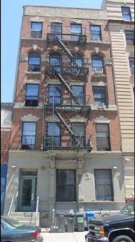
Find your new home at 545 W 133rd St in New York, NY. You'll find this community in the Manhattanville area of New York. From amenities to availability, the professional leasing staff will assist you in finding your dream apartment. It's time to find your new home. Contact or stop by the 545 W 133rd St leasing office to see available floor plans.
545 W 133rd St is an apartment community located in New York County and the 10027 ZIP Code. This area is served by the New York City Geographic District # 5 attendance zone.
Manhattanville, sometimes referred to as West Harlem, is a vibrant neighborhood combining the urban vibe of Harlem with the intellectual presence of nearby Columbia University and the City College of New York. A host of university students, faculty, and staff call Manhattanville home, shaping much of the area’s rental opportunities.
Manhattanville’s cultural legacy is rich, touting numerous jazz clubs throughout the neighborhood along with quick access to the famous Apollo Theater. Although the neighborhood sits far north in Manhattan, a wealth of public transportation options make it easy to connect to the rest of NYC.
Learn more about living in Manhattanville| Colleges & Universities | Distance | ||
|---|---|---|---|
| Colleges & Universities | Distance | ||
| Walk: | 6 min | 0.3 mi | |
| Walk: | 12 min | 0.6 mi | |
| Walk: | 16 min | 0.9 mi | |
| Walk: | 18 min | 1.0 mi |


Transportation options available in New York include 137 Street-City College, located 0.3 mile from 545 W 133rd St. 545 W 133rd St is near LaGuardia, located 7.4 miles or 16 minutes away, and Newark Liberty International, located 22.6 miles or 27 minutes away.
| Transit / Subway | Distance | ||
|---|---|---|---|
| Transit / Subway | Distance | ||
|
|
Walk: | 5 min | 0.3 mi |
|
|
Walk: | 6 min | 0.3 mi |
|
|
Walk: | 12 min | 0.6 mi |
|
|
Walk: | 12 min | 0.7 mi |
|
|
Walk: | 13 min | 0.7 mi |
| Commuter Rail | Distance | ||
|---|---|---|---|
| Commuter Rail | Distance | ||
|
|
Drive: | 4 min | 1.7 mi |
|
|
Drive: | 7 min | 3.1 mi |
|
|
Drive: | 10 min | 3.4 mi |
| Drive: | 8 min | 4.3 mi | |
|
|
Drive: | 11 min | 5.1 mi |
| Airports | Distance | ||
|---|---|---|---|
| Airports | Distance | ||
|
LaGuardia
|
Drive: | 16 min | 7.4 mi |
|
Newark Liberty International
|
Drive: | 27 min | 22.6 mi |
Time and distance from 545 W 133rd St.
| Shopping Centers | Distance | ||
|---|---|---|---|
| Shopping Centers | Distance | ||
| Walk: | 15 min | 0.8 mi | |
| Drive: | 6 min | 2.3 mi | |
| Drive: | 12 min | 6.9 mi |
| Parks and Recreation | Distance | ||
|---|---|---|---|
| Parks and Recreation | Distance | ||
|
St. Nicholas Park
|
Walk: | 13 min | 0.7 mi |
|
Morningside Park
|
Drive: | 3 min | 1.1 mi |
|
Jackie Robinson Park
|
Drive: | 3 min | 1.2 mi |
|
Northern Manhattan Parks
|
Drive: | 3 min | 1.4 mi |
|
Riverbank State Park
|
Drive: | 5 min | 2.2 mi |
| Hospitals | Distance | ||
|---|---|---|---|
| Hospitals | Distance | ||
| Drive: | 4 min | 1.7 mi | |
| Drive: | 4 min | 1.9 mi | |
| Drive: | 6 min | 2.0 mi |
| Military Bases | Distance | ||
|---|---|---|---|
| Military Bases | Distance | ||
| Drive: | 23 min | 10.0 mi | |
| Drive: | 24 min | 13.8 mi |
What Are Walk Score®, Transit Score®, and Bike Score® Ratings?
Walk Score® measures the walkability of any address. Transit Score® measures access to public transit. Bike Score® measures the bikeability of any address.
What is a Sound Score Rating?
A Sound Score Rating aggregates noise caused by vehicle traffic, airplane traffic and local sources


