$3,650
/ Month
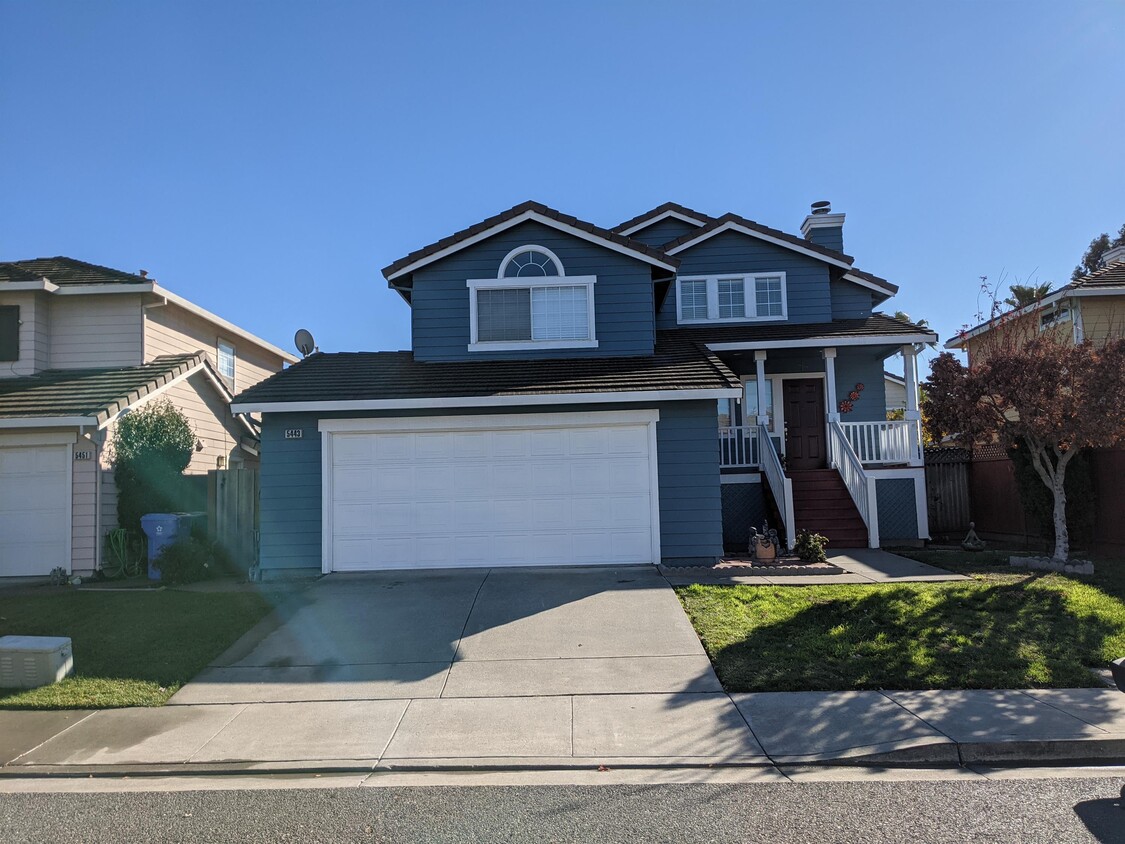
5443 Andromeda Cir
Fremont, CA 94538
2 Weeks Ago
|
Edit
Favorites
5443 Andromeda Cir

Favorites
Check Back Soon for Upcoming Availability
| Beds | Baths | Average SF |
|---|---|---|
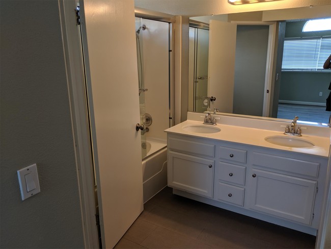
| 3 Bedrooms 3 Bedrooms 3 Br | 2.5 Baths 2.5 Baths 2.5 Ba | 1,422 SF |
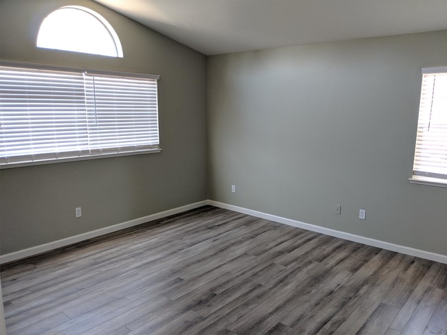
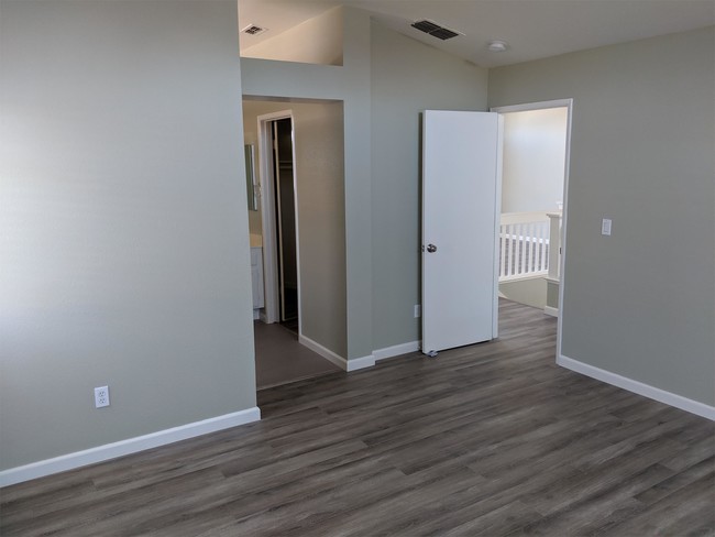
About This Property
Earliest showing starting on December 20th, 2021. This single family house is located right off Stevenson Blvd exit of I-880. 3 miles from Fremont BART Station, 14 miles from Facebook HQ and 6 miles from Tesla. Recently updated flooring and new appliances. House does have AC. Tenant must provide own washer/dryer. Gardening and watering is tenant's responsibility. Tenant may plant in backyard so long as all plants are in pots. All utilities will be tenant's responsibility. Schools: Steven Millard Elementary School G. M. Walters Junior High School John F. Kennedy High School
5443 Andromeda Cir is a house located in Alameda County and the 94538 ZIP Code. This area is served by the Fremont Unified attendance zone.
Location
Get Directions
Blacow is a suburban neighborhood about three miles south of Downtown Fremont. Blacow is family-friendly with several good schools, childcare centers, and parks. Along with large neighborhood parks, Blacow residents have access to amazing green spaces as well, including the Don Edwards San Francisco Bay National Wildlife Refuge and the Coyote Creek Lagoon Trail. This beautiful neighborhood is quiet and has mid-range to upscale single-family homes and apartments available for rent. Although residents certainly enjoy proximity to Downtown Fremont’s excellent shopping, dining, and cultural scenes, Blacow is convenient to several large commercial centers like NewPark Mall and Pacific Commons Shopping Center, which provides suburban staples including a movie theater, department stores, and chain restaurants. The south side of the neighborhood borders Interstate 880 allowing for easier commutes throughout the Bay Area and Silicon Valley.
Learn more about living in BlacowBelow are rent ranges for similar nearby apartments
Education
| Colleges & Universities | Distance | ||
|---|---|---|---|
| Colleges & Universities | Distance | ||
| Drive: | 5 min | 2.1 mi | |
| Drive: | 12 min | 5.7 mi | |
| Drive: | 17 min | 11.9 mi | |
| Drive: | 28 min | 20.1 mi |
5443 Andromeda Cir is within 5 minutes or 2.1 miles from Ohlone College, Newark. It is also near Ohlone College, Fremont Campus and Palmer College of Chiropractic West Campus.
Schools


Public Elementary School
Grades K-5
343 Students
Nearby
Public Elementary School
Grades 1-5
495 Students
Attendance Zone
Public Middle School
Grades 6-8
1,071 Students
Attendance Zone
Public High School
Grades 9-12
1,347 Students
Attendance Zone
Private Elementary, Middle & High School
Grades 5-12
Nearby
Private Elementary School
Grades PK-K
Nearby
Private Elementary & Middle School
Grades K-8
Nearby
School data provided by
 The GreatSchools Rating helps parents compare schools within a state based on a variety of school quality indicators and provides a helpful picture of how effectively each school serves all of its students. Ratings are on a scale of 1 (below average) to 10 (above average) and can include test scores, college readiness, academic progress, advanced courses, equity, discipline and attendance data. We also advise parents to visit schools, consider other information on school performance and programs, and consider family needs as part of the school selection process.
View GreatSchools Rating Methodology
Data provided by GreatSchools.org © 2026. All rights reserved.
View GreatSchools Rating Methodology
Data provided by GreatSchools.org © 2026. All rights reserved.
Transportation options available in Fremont include Fremont Station, located 3.0 miles from 5443 Andromeda Cir. 5443 Andromeda Cir is near Norman Y Mineta San Jose International, located 15.9 miles or 21 minutes away, and Metro Oakland International, located 21.7 miles or 28 minutes away.
| Transit / Subway | Distance | ||
|---|---|---|---|
| Transit / Subway | Distance | ||
|
|
Drive: | 7 min | 3.0 mi |
|
|
Drive: | 7 min | 3.2 mi |
|
|
Drive: | 9 min | 4.1 mi |
|
|
Drive: | 13 min | 7.3 mi |
| Drive: | 21 min | 15.2 mi |
| Commuter Rail | Distance | ||
|---|---|---|---|
| Commuter Rail | Distance | ||
| Drive: | 8 min | 4.6 mi | |
| Drive: | 8 min | 4.8 mi | |
| Drive: | 18 min | 13.5 mi | |
| Drive: | 26 min | 18.6 mi | |
| Drive: | 25 min | 18.6 mi |
| Airports | Distance | ||
|---|---|---|---|
| Airports | Distance | ||
|
Norman Y Mineta San Jose International
|
Drive: | 21 min | 15.9 mi |
|
Metro Oakland International
|
Drive: | 28 min | 21.7 mi |
Time and distance from 5443 Andromeda Cir.
| Shopping Centers | Distance | ||
|---|---|---|---|
| Shopping Centers | Distance | ||
| Walk: | 15 min | 0.8 mi | |
| Walk: | 16 min | 0.9 mi | |
| Drive: | 3 min | 1.1 mi |
5443 Andromeda Cir has 3 shopping centers within 1.1 miles, which is about a 3-minute drive. The miles and minutes will be for the farthest away property.
| Parks and Recreation | Distance | ||
|---|---|---|---|
| Parks and Recreation | Distance | ||
|
Central Park (Lake Elizabeth)
|
Drive: | 7 min | 3.1 mi |
|
Niles Canyon Railway
|
Drive: | 10 min | 5.5 mi |
|
Quarry Lakes Regional Recreation Area
|
Drive: | 9 min | 5.5 mi |
|
Alameda Creek Regional Trail
|
Drive: | 10 min | 5.8 mi |
|
Niles Community Park
|
Drive: | 12 min | 6.0 mi |
5443 Andromeda Cir has 5 parks within 6.0 miles, including Central Park (Lake Elizabeth), Quarry Lakes Regional Recreation Area, and Alameda Creek Regional Trail.
| Hospitals | Distance | ||
|---|---|---|---|
| Hospitals | Distance | ||
| Drive: | 5 min | 2.5 mi | |
| Drive: | 7 min | 3.3 mi | |
| Drive: | 15 min | 10.7 mi |
5443 Andromeda Cir has 3 hospitals within 10.7 miles, the nearest is Kaiser Foundation Hospital - Fremont which is 2.5 miles away and a 5 minute drive.
| Military Bases | Distance | ||
|---|---|---|---|
| Military Bases | Distance | ||
| Drive: | 27 min | 18.7 mi |
5443 Andromeda Cir is 18.7 miles and a 27 minute drive from Ames Research Center.
You May Also Like
Similar Rentals Nearby


What Are Walk Score®, Transit Score®, and Bike Score® Ratings?
Walk Score® measures the walkability of any address. Transit Score® measures access to public transit. Bike Score® measures the bikeability of any address.
What is a Sound Score Rating?
A Sound Score Rating aggregates noise caused by vehicle traffic, airplane traffic and local sources

5443 Andromeda Cir
Fremont, CA 94538