

$3,600
/ Month
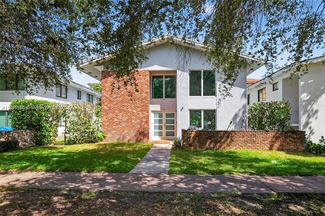
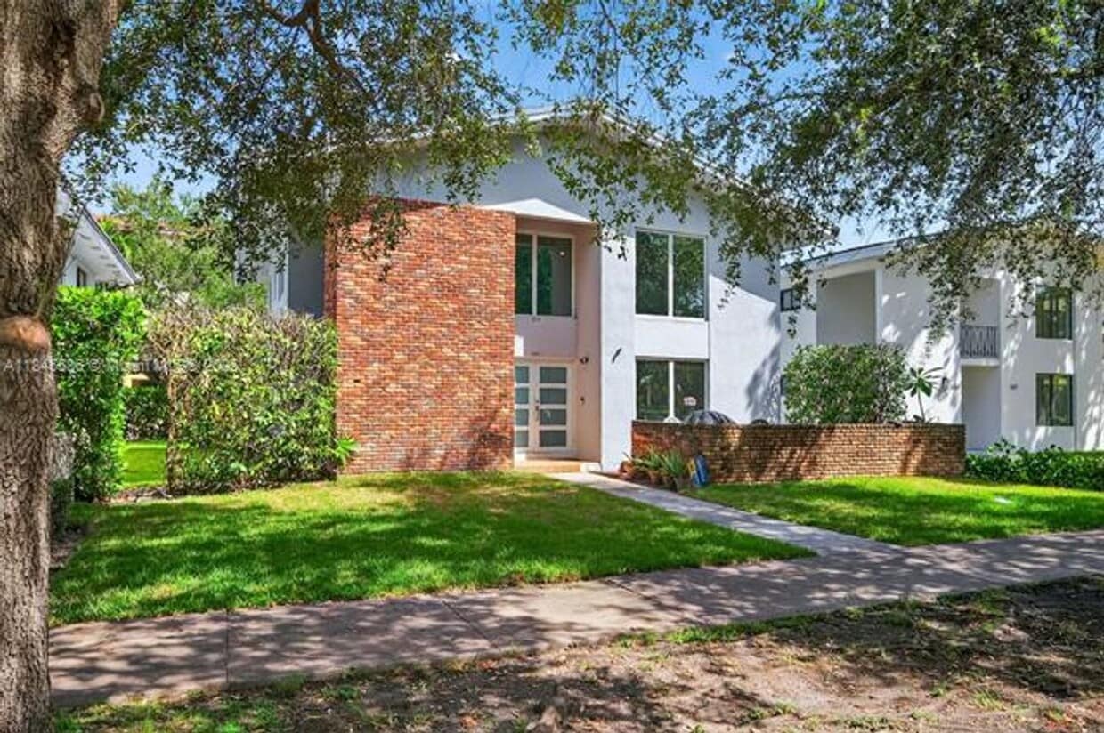
539 Menendez Ave
Coral Gables, FL 33146
Today
|
Edit
Favorites
786-560-3537
-
Bedrooms
2
-
Bathrooms
2
-
Square Feet
1,275 sq ft
-
Available
Available Now
539 Menendez Ave

Favorites
About This Home
$3,600 deposit,
Available Now
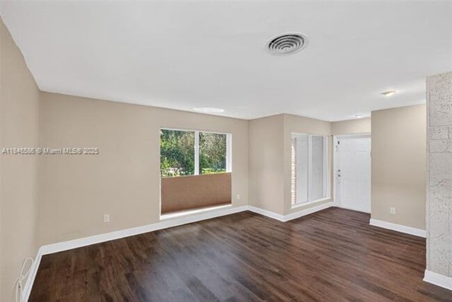
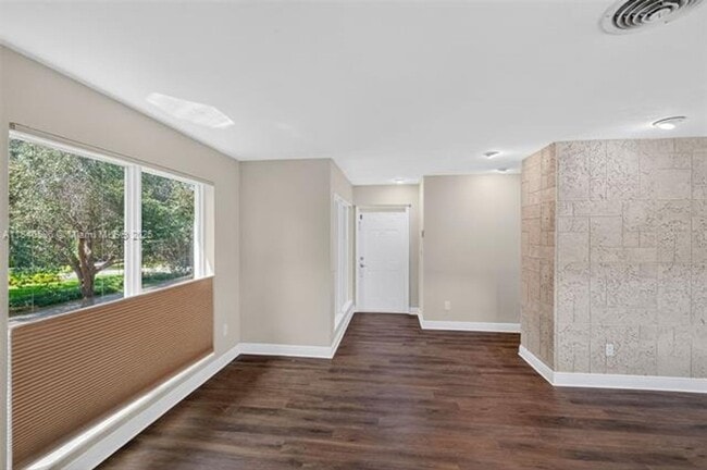
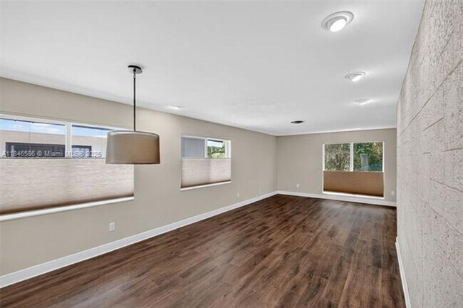
Courtesy of The Keyes Company Now available! Charming 2BD/2BA condo in the heart of Coral Gables. This bright, well-maintained unit features an open living area, full-length windows with lush views, front and rear entrances, and a spacious kitchen with dining space. Includes washer/dryer and one designated parking space. Walk to UM and enjoy easy access to Downtown Coral Gables, Coconut Grove, and the M-Path trail.
539 Menendez Ave is a house located in Miami/Dade County and the 33146 ZIP Code. This area is served by the Miami-Dade County Public Schools attendance zone.
* Price shown is base rent. Excludes user-selected optional fees and variable or usage-based fees and required charges due at or prior to move-in or at move-out. Price, availability, fees, and any applicable rent special are subject to change without notice.
* Square footage definitions vary. Displayed square footage is approximate.
Fees and Policies
The fees below are based on community-supplied data and may exclude additional fees and utilities.
-
One-Time Basics
-
Due at Move-In
-
Security Deposit - RefundableCharged per unit.$3,600
-
-
Due at Move-In
Property Fee Disclaimer: Based on community-supplied data and independent market research. Subject to change without notice. May exclude fees for mandatory or optional services and usage-based utilities.
House Features
- Dishwasher
Contact
- Listed by Affluence Deluxe Group @ EXP Realty | Affluence Deluxe Group @ EXP Realty
- Phone Number
- Contact
Location
Get Directions
Amenities
- Dishwasher
The Upper Riviera neighborhood resides in the heart of Coral Gables, Florida. A South Miami suburb located five miles from the city center, the neighborhood surrounds the University of Miami. Within minutes of several parks and golf courses, Upper Riviera makes it easy to get out and enjoy the beautiful Florida weather.
For a bite to eat, check out popular spots near Le Jeune Road, located within walking or driving distance from your apartment. Indulge in authentic Cuban fare and fresh, local seafood at Havana Harrys. Mix it up at Caffe Vialetto, an Italian-Latin fusion restaurant that serves tasty and unique menu items such as Caribbean risotto and spicy calamari.
Learn more about living in Upper Riviera
Education
| Colleges & Universities | Distance | ||
|---|---|---|---|
| Colleges & Universities | Distance | ||
| Drive: | 3 min | 1.2 mi | |
| Drive: | 7 min | 3.4 mi | |
| Drive: | 8 min | 4.1 mi | |
| Drive: | 14 min | 6.8 mi |
539 Menendez Ave is within 3 minutes or 1.2 miles from Univ. of Miami, Coral Gables. It is also near USAHS and Miami Dade Coll., InterAm..
Schools


Public Elementary School
Grades PK-5
566 Students
Attendance Zone
Public Middle School
Grades 6-8
888 Students
Attendance Zone
Public High School
Grades 9-12
2,824 Students
Attendance Zone
Private Elementary, Middle & High School
Grades PK-12
847 Students
Nearby
Private Elementary & Middle School
Grades PK-8
316 Students
Nearby
Private Elementary School
Grades PK-5
Nearby
School data provided by
 The GreatSchools Rating helps parents compare schools within a state based on a variety of school quality indicators and provides a helpful picture of how effectively each school serves all of its students. Ratings are on a scale of 1 (below average) to 10 (above average) and can include test scores, college readiness, academic progress, advanced courses, equity, discipline and attendance data. We also advise parents to visit schools, consider other information on school performance and programs, and consider family needs as part of the school selection process.
View GreatSchools Rating Methodology
Data provided by GreatSchools.org © 2025. All rights reserved.
View GreatSchools Rating Methodology
Data provided by GreatSchools.org © 2025. All rights reserved.
Transportation options available in Coral Gables include Financial District, located 5.4 miles from 539 Menendez Ave. 539 Menendez Ave is near Miami International, located 10.6 miles or 22 minutes away, and Fort Lauderdale/Hollywood International, located 29.0 miles or 42 minutes away.
| Transit / Subway | Distance | ||
|---|---|---|---|
| Transit / Subway | Distance | ||
|
|
Drive: | 10 min | 5.4 mi |
|
|
Drive: | 10 min | 5.6 mi |
|
|
Drive: | 10 min | 5.9 mi |
|
Airport Station
|
Drive: | 16 min | 6.4 mi |
|
Miami Intl Airport Ground Level
|
Drive: | 14 min | 6.8 mi |
| Commuter Rail | Distance | ||
|---|---|---|---|
| Commuter Rail | Distance | ||
|
|
Walk: | 20 min | 1.1 mi |
|
|
Drive: | 2 min | 1.2 mi |
|
|
Drive: | 3 min | 2.0 mi |
|
|
Drive: | 4 min | 2.3 mi |
|
|
Drive: | 6 min | 3.4 mi |
| Airports | Distance | ||
|---|---|---|---|
| Airports | Distance | ||
|
Miami International
|
Drive: | 22 min | 10.6 mi |
|
Fort Lauderdale/Hollywood International
|
Drive: | 42 min | 29.0 mi |
Time and distance from 539 Menendez Ave.
| Shopping Centers | Distance | ||
|---|---|---|---|
| Shopping Centers | Distance | ||
| Walk: | 15 min | 0.8 mi | |
| Walk: | 19 min | 1.0 mi |
539 Menendez Ave has 2 shopping centers within 1.0 miles, which is about a 19-minute walk. The miles and minutes will be for the farthest away property.
| Parks and Recreation | Distance | ||
|---|---|---|---|
| Parks and Recreation | Distance | ||
|
Gifford Arboretum
|
Drive: | 3 min | 1.5 mi |
|
The Barnacle Historic State Park
|
Drive: | 3 min | 1.5 mi |
|
The Kampong
|
Drive: | 3 min | 1.8 mi |
|
Sense of Wonder Nature Center and A.D. Barnes Park
|
Drive: | 8 min | 3.7 mi |
|
Fairchild Tropical Botanic Garden
|
Drive: | 11 min | 3.9 mi |
539 Menendez Ave has 5 parks within 3.9 miles, including Gifford Arboretum, The Kampong, and The Barnacle Historic State Park.
| Hospitals | Distance | ||
|---|---|---|---|
| Hospitals | Distance | ||
| Walk: | 16 min | 0.9 mi | |
| Drive: | 4 min | 2.4 mi | |
| Drive: | 4 min | 2.4 mi |
539 Menendez Ave has 3 hospitals within 2.4 miles, the nearest is Doctors Hospital which is 0.9 mile away and a 16 minute walk.
You May Also Like
Similar Rentals Nearby


What Are Walk Score®, Transit Score®, and Bike Score® Ratings?
Walk Score® measures the walkability of any address. Transit Score® measures access to public transit. Bike Score® measures the bikeability of any address.
What is a Sound Score Rating?
A Sound Score Rating aggregates noise caused by vehicle traffic, airplane traffic and local sources
539 Menendez Ave
Coral Gables, FL 33146