
$1,950
/ Month
5350 Atlas St
Los Angeles, CA 90032
2 Weeks Ago
Favorites
5350 Atlas St

Favorites
Check Back Soon for Upcoming Availability
| Beds | Baths | Average SF |
|---|---|---|
| Studio Studio 0 Br | 1 Bath 1 Bath 1 Ba | 350 SF |
About This Property
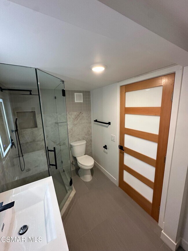
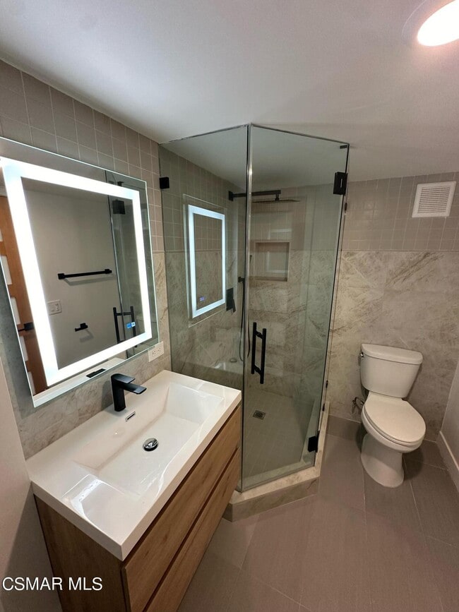
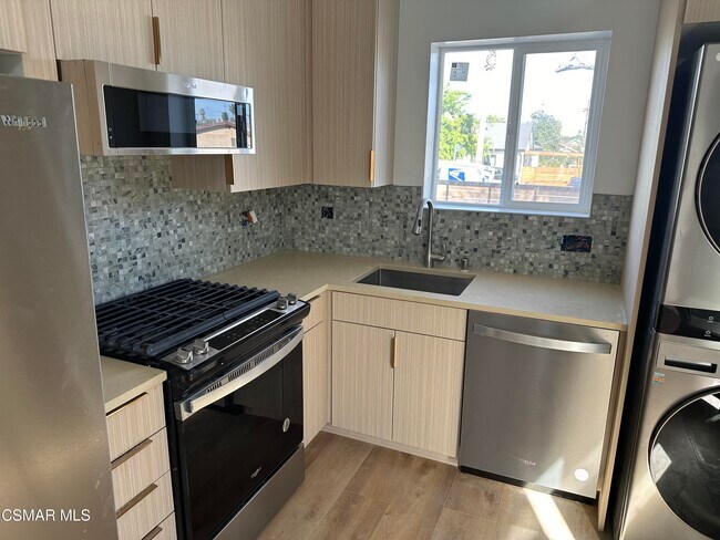
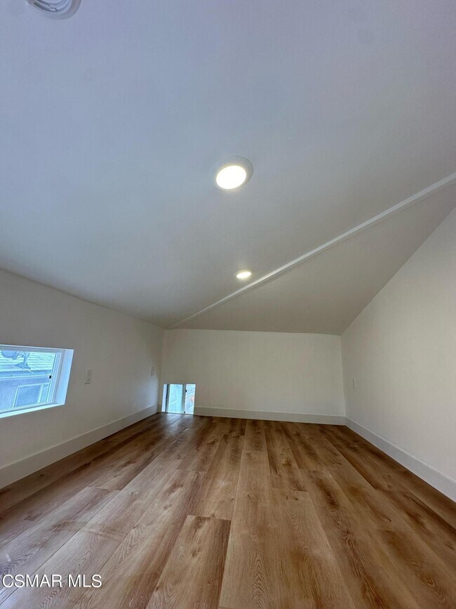
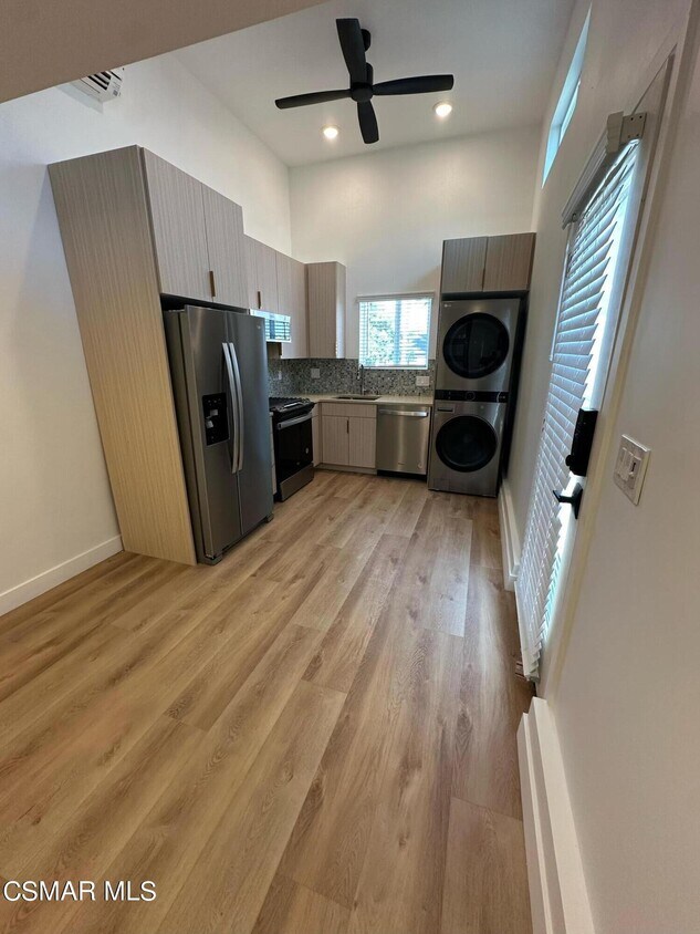
Discover this completely renovated studio with loft in beautiful North East hillside Los Angeles, just steps away from South Pasadena. 1 of 3 units on updated property. Spacious upstairs loft sleeping area with downstairs living and kitchen area. This vaulted ceiling studio features a full-size bathroom with a step-in glass enclosed shower, waterfall showerhead, and backlit mirror. Enjoy the large closet with built-in shelving system, hardwood floors, and the convenience of keyless door entry. Stay comfortable with central air and heat, plus a ceiling fan. The kitchen boasts brand-new, full-size stainless steel Whirlpool appliances, including a French door fridge, gas oven range, microwave, dishwasher, and a stackable washer/dryer in unit. It also features quartz countertops, modern cabinetry, and a stainless steel undermount sink. The unit includes a small, private outdoor seating area with gate access. Plenty of street parking always available. Close to the South Pasadena weekly farmer's market and very close to Target, Trader Joe's, Pavillions and great restaurants. Close to DTLA, Old Town Pasadena and Alhambra. Available June 20th. Priced at $1950 per month with a one-month security deposit. Loft railing to be installed next week.Renter is responsible for gas, electric, and trash. Water usage is billed back by owner. Small pet considered with additional pet rent at $45 per month.
5350 Atlas St is an apartment community located in Los Angeles County and the 90032 ZIP Code.
Features
Dishwasher
Refrigerator
Disposal
Ice Maker
- Dishwasher
- Disposal
- Ice Maker
- Oven
- Range
- Refrigerator
- Freezer
- Breakfast Nook
Location
Get Directions
A quiet suburb outside of Los Angeles, Monterey Hills is known for its rolling hills, winding residential streets, and elevated city views. Check out Elephant Hill, a popular place to bike or hike that offers beautiful views of the neighborhood. Herman Park is nestled along Highway 110 in the north end of the neighborhood, offering tennis courts, playgrounds, and a dog park. And for more outdoor recreation, visit the biking paths and hiking trails at Ernest E. Debs Regional Park, bordering Monterey Hills.
Monterey Hills is a more secluded part of Northeast Los Angeles with larger lots, single-family homes, and tree-lined streets. However, if you cross over Highway 110, you’ll find theatres, restaurants, services, and more. Monterey Hills is located just seven miles northeast of Downtown Los Angeles and eight miles east of major attractions such as Griffith Park, the Los Angeles Zoo, the Greek Theatre, and Glendale Galleria.
Learn more about living in Monterey HillsBelow are rent ranges for similar nearby apartments
| Beds | Average Size | Lowest | Typical | Premium |
|---|---|---|---|---|
| Studio Studio Studio | 440 Sq Ft | $1,856 | $2,365 | $3,059 |
| 1 Bed 1 Bed 1 Bed | 628 Sq Ft | $1,750 | $2,335 | $3,109 |
| 2 Beds 2 Beds 2 Beds | 998-1001 Sq Ft | $1,647 | $3,087 | $5,874 |
| 3 Beds 3 Beds 3 Beds | 1210 Sq Ft | $1,901 | $3,712 | $7,900 |
| 4 Beds 4 Beds 4 Beds | 1665 Sq Ft | $1,060 | $3,825 | $8,000 |
Amenities
- Dishwasher
- Disposal
- Ice Maker
- Oven
- Range
- Refrigerator
- Freezer
- Breakfast Nook
Education
| Colleges & Universities | Distance | ||
|---|---|---|---|
| Colleges & Universities | Distance | ||
| Drive: | 8 min | 3.2 mi | |
| Drive: | 9 min | 3.9 mi | |
| Drive: | 13 min | 5.0 mi | |
| Drive: | 14 min | 5.4 mi |
5350 Atlas St is within 8 minutes or 3.2 miles from Art Center College of Design. It is also near Cal State Los Angeles and Occidental College.
Transportation options available in Los Angeles include South Pasadena, located 2.0 miles from 5350 Atlas St. 5350 Atlas St is near Bob Hope, located 19.4 miles or 30 minutes away, and Los Angeles International, located 22.2 miles or 38 minutes away.
| Transit / Subway | Distance | ||
|---|---|---|---|
| Transit / Subway | Distance | ||
|
|
Drive: | 6 min | 2.0 mi |
|
|
Drive: | 9 min | 3.5 mi |
|
|
Drive: | 10 min | 3.9 mi |
|
|
Drive: | 12 min | 5.0 mi |
|
|
Drive: | 13 min | 5.6 mi |
| Commuter Rail | Distance | ||
|---|---|---|---|
| Commuter Rail | Distance | ||
|
|
Drive: | 14 min | 6.1 mi |
|
|
Drive: | 12 min | 6.2 mi |
|
|
Drive: | 17 min | 8.7 mi |
|
|
Drive: | 18 min | 9.9 mi |
| Drive: | 16 min | 10.1 mi |
| Airports | Distance | ||
|---|---|---|---|
| Airports | Distance | ||
|
Bob Hope
|
Drive: | 30 min | 19.4 mi |
|
Los Angeles International
|
Drive: | 38 min | 22.2 mi |
Time and distance from 5350 Atlas St.
| Shopping Centers | Distance | ||
|---|---|---|---|
| Shopping Centers | Distance | ||
| Drive: | 4 min | 1.2 mi | |
| Drive: | 4 min | 1.4 mi | |
| Drive: | 5 min | 1.8 mi |
5350 Atlas St has 3 shopping centers within 1.8 miles, which is about a 5-minute drive. The miles and minutes will be for the farthest away property.
| Parks and Recreation | Distance | ||
|---|---|---|---|
| Parks and Recreation | Distance | ||
|
Audubon Center at Debs Park
|
Drive: | 11 min | 4.9 mi |
|
Kidspace Children's Museum
|
Drive: | 14 min | 5.4 mi |
|
Huntington Botanical Gardens
|
Drive: | 14 min | 5.5 mi |
|
Elysian Park
|
Drive: | 17 min | 6.9 mi |
|
Elyria Canyon Park
|
Drive: | 16 min | 7.4 mi |
5350 Atlas St has 5 parks within 7.4 miles, including Audubon Center at Debs Park, Huntington Botanical Gardens, and Kidspace Children's Museum.
| Hospitals | Distance | ||
|---|---|---|---|
| Hospitals | Distance | ||
| Drive: | 4 min | 1.6 mi | |
| Drive: | 8 min | 3.6 mi | |
| Drive: | 8 min | 3.9 mi |
5350 Atlas St has 3 hospitals within 3.9 miles, the nearest is Alhambra Hospital Medical Center which is 1.6 miles away and a 4 minute drive.
| Military Bases | Distance | ||
|---|---|---|---|
| Military Bases | Distance | ||
| Drive: | 35 min | 23.8 mi | |
| Drive: | 39 min | 26.8 mi |
5350 Atlas St is 23.8 miles from Los Angeles Air Force Base, and is convenient to other military bases, including Los Alamitos Army Airfield.
You May Also Like
Similar Rentals Nearby


 - Violet on Virgil")


 - AVA Burbank")


What Are Walk Score®, Transit Score®, and Bike Score® Ratings?
Walk Score® measures the walkability of any address. Transit Score® measures access to public transit. Bike Score® measures the bikeability of any address.
What is a Sound Score Rating?
A Sound Score Rating aggregates noise caused by vehicle traffic, airplane traffic and local sources
5350 Atlas St
Los Angeles, CA 90032