
The Equestrian At Pelham Parkway
1680 Pelham Pkwy S,
Bronx, NY 10461
$1,700 - $2,650
Studio - 2 Beds
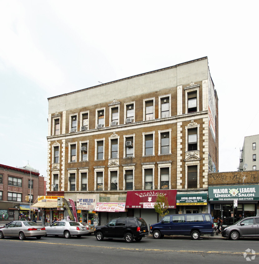
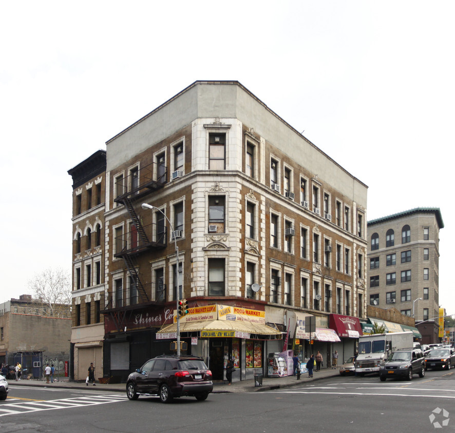
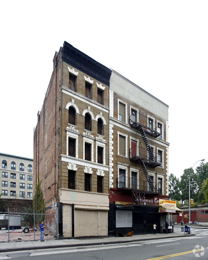
531-535 E Tremont Ave offers a combination of comfort and style. In the 10457 Zip code of Bronx on E. Tremont Ave, renters have an easy connection to great points of interest. Here at this community, the leasing team will be ready to help you find your perfect home. Come for a visit to see the available floorplan options. It's all waiting for you at 531-535 E Tremont Ave. Stop by the leasing office to talk about leasing your next apartment.
531-535 E Tremont Ave is an apartment community located in Bronx County and the 10457 ZIP Code. This area is served by the New York City Geographic District #12 attendance zone.
Air Conditioning
Double Pane Windows
Heating
Views
Tremont is a hilly neighborhood that features a variety of historic homes and low to mid-rise apartment buildings. Adjacent to the Bronx Park and the Bronx Zoo, this neighborhood sits just south of 181st Street and just north of Interstate 95 and Crotona Park. With several parks in and around the neighborhood, Tremont provides just enough green space to offset its urban setting. Similar to many New York neighborhoods, Tremont features brick buildings adorned with fire escapes, corner markets, locally owned shops, and wide, pedestrian-friendly streets.
With Manhattan just seven miles southwest of Tremont, commuting into the city is simple, especially with easy access to mass transit. Yankee Stadium, Fordham University, and New York Botanical Garden sit near Tremont as well.
Learn more about living in TremontCompare neighborhood and city base rent averages by bedroom.
| Tremont | Bronx, NY | |
|---|---|---|
| Studio | $1,283 | $1,636 |
| 1 Bedroom | $1,719 | $1,634 |
| 2 Bedrooms | $1,822 | $2,089 |
| 3 Bedrooms | $2,076 | $2,373 |
| Colleges & Universities | Distance | ||
|---|---|---|---|
| Colleges & Universities | Distance | ||
| Drive: | 4 min | 1.2 mi | |
| Drive: | 4 min | 1.6 mi | |
| Drive: | 5 min | 1.8 mi | |
| Drive: | 5 min | 2.2 mi |


Transportation options available in Bronx include Tremont Avenue, located 0.7 mile from 531-535 E Tremont Ave. 531-535 E Tremont Ave is near LaGuardia, located 9.7 miles or 19 minutes away, and John F Kennedy International, located 18.7 miles or 27 minutes away.
| Transit / Subway | Distance | ||
|---|---|---|---|
| Transit / Subway | Distance | ||
|
|
Walk: | 13 min | 0.7 mi |
|
|
Walk: | 16 min | 0.9 mi |
|
|
Walk: | 17 min | 0.9 mi |
|
|
Walk: | 18 min | 0.9 mi |
|
|
Drive: | 3 min | 1.1 mi |
| Commuter Rail | Distance | ||
|---|---|---|---|
| Commuter Rail | Distance | ||
|
|
Walk: | 4 min | 0.2 mi |
|
|
Drive: | 3 min | 1.3 mi |
|
|
Drive: | 6 min | 2.0 mi |
|
|
Drive: | 5 min | 2.1 mi |
|
|
Drive: | 6 min | 2.2 mi |
| Airports | Distance | ||
|---|---|---|---|
| Airports | Distance | ||
|
LaGuardia
|
Drive: | 19 min | 9.7 mi |
|
John F Kennedy International
|
Drive: | 27 min | 18.7 mi |
Time and distance from 531-535 E Tremont Ave.
| Shopping Centers | Distance | ||
|---|---|---|---|
| Shopping Centers | Distance | ||
| Walk: | 13 min | 0.7 mi | |
| Walk: | 16 min | 0.8 mi | |
| Walk: | 18 min | 0.9 mi |
| Parks and Recreation | Distance | ||
|---|---|---|---|
| Parks and Recreation | Distance | ||
|
Crotona Park
|
Walk: | 8 min | 0.4 mi |
|
Claremont Park
|
Drive: | 4 min | 1.4 mi |
|
Bronx Zoo
|
Drive: | 5 min | 1.5 mi |
|
Poe Park
|
Drive: | 5 min | 1.9 mi |
|
Starlight Park
|
Drive: | 6 min | 2.5 mi |
| Hospitals | Distance | ||
|---|---|---|---|
| Hospitals | Distance | ||
| Walk: | 9 min | 0.5 mi | |
| Drive: | 4 min | 1.4 mi | |
| Drive: | 7 min | 3.0 mi |
| Military Bases | Distance | ||
|---|---|---|---|
| Military Bases | Distance | ||
| Drive: | 17 min | 9.2 mi | |
| Drive: | 31 min | 14.8 mi |
What Are Walk Score®, Transit Score®, and Bike Score® Ratings?
Walk Score® measures the walkability of any address. Transit Score® measures access to public transit. Bike Score® measures the bikeability of any address.
What is a Sound Score Rating?
A Sound Score Rating aggregates noise caused by vehicle traffic, airplane traffic and local sources


