

$3,400
Total Monthly Price
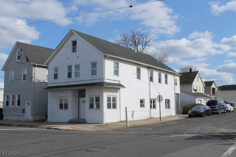
519 Roosevelt Ave Unit 1
Carteret, NJ 07008
2 Weeks Ago
|
Edit
Favorites
848-281-3269
-
Bedrooms
4
-
Bathrooms
2
-
Square Feet
1,400 sq ft
-
Available
Available Now
Highlights
- Basement
- Smoke Free
519 Roosevelt Ave Unit 1

Favorites
About This Home
12 Month Lease,
$5,100 deposit,
Available Now
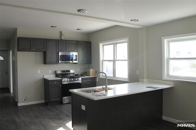
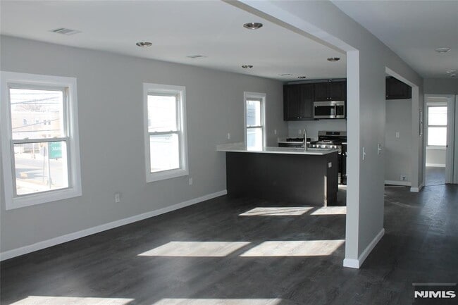
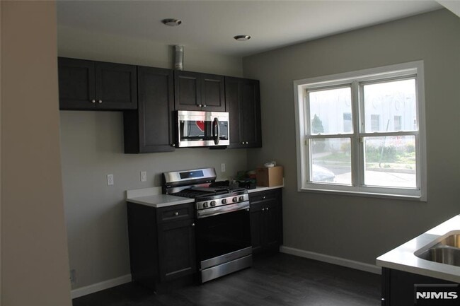
REMODELED 4 BEDROOM 2 FULL BATHROOMS READY TO MOVE INTO. Full basement for storage.
519 Roosevelt Ave is an apartment community located in Middlesex County and the 07008 ZIP Code. This area is served by the Carteret Public School District attendance zone.
* Price shown is total price based on community-supplied monthly required fees. Excludes user-selected optional fees and variable or usage-based fees and required charges due at or prior to move-in or at move-out. Price, availability, fees, and any applicable rent special are subject to change without notice.
* Square footage definitions vary. Displayed square footage is approximate.
Apartment Features
Air Conditioning
Dishwasher
Washer/Dryer Hookup
Stainless Steel Appliances
- Washer/Dryer Hookup
- Air Conditioning
- Heating
- Ceiling Fans
- Smoke Free
- Storage Space
- Dishwasher
- Stainless Steel Appliances
- Kitchen
- Oven
- Instant Hot Water
- Quartz Countertops
- Basement
- Storage Space
Fees and Policies
The fees listed below are community-provided and may exclude utilities or add-ons. All payments are made directly to the property and are non-refundable unless otherwise specified.
- One-Time Move-In Fees
-
Broker Fee$0
- Parking
-
Street--
Details
Utilities Included
-
Trash Removal
-
Sewer
Property Information
-
Built in 1940
-
2 units
Contact
- Phone Number
- Contact
Location
Get Directions
Located directly across the Arthur Kill from Staten Island, Carteret was once part of the Woodbridge Township. It became the borough of Roosevelt in 1906 and was renamed Carteret in 1922. This popular community is bordered by the Rahway River to the north, Arthur Kill to the east, and the Ernest L. Oros Wildlife Preserve to the west. Due to its central location, the borough bills itself as the "Center of it All."
Residents enjoy a fantastic location and beautiful parks. Carteret Waterfront Park has a fishing pier and access to two hiking trails: Danielle's Garden Trail and the Waterfront Fitness Trail. Shopping in Carteret is plentiful -- the brick-paved sidewalks and outdoor cafes along Washington Avenue provide historic charm and locally-owned businesses, while the shops and restaurants along Roosevelt Avenue have a more modern feel. With just 22 miles to Manhattan, 10 miles to Newark, and 70 miles to Philadelphia, residents can easily commute to nearby cities.
Learn more about living in Carteret
Education
| Colleges & Universities | Distance | ||
|---|---|---|---|
| Colleges & Universities | Distance | ||
| Drive: | 13 min | 7.3 mi | |
| Drive: | 17 min | 8.9 mi | |
| Drive: | 18 min | 10.2 mi | |
| Drive: | 22 min | 13.1 mi |
519 Roosevelt Ave Unit 1 is within 13 minutes or 7.3 miles from Union County Coll., Elizabeth. It is also near Kean University and Coll. of Staten Island, CUNY.
Schools


Public Elementary School
Grades K-5
Attendance Zone
Public Elementary School
Grades PK-5
Attendance Zone
Public High School
Grades 9-12
Attendance Zone
Private Elementary, Middle & High School
Grades K-12
Nearby
Private Elementary School
Grades PK-5
Nearby
School data provided by
 The GreatSchools Rating helps parents compare schools within a state based on a variety of school quality indicators and provides a helpful picture of how effectively each school serves all of its students. Ratings are on a scale of 1 (below average) to 10 (above average) and can include test scores, college readiness, academic progress, advanced courses, equity, discipline and attendance data. We also advise parents to visit schools, consider other information on school performance and programs, and consider family needs as part of the school selection process.
View GreatSchools Rating Methodology
Data provided by GreatSchools.org © 2026. All rights reserved.
View GreatSchools Rating Methodology
Data provided by GreatSchools.org © 2026. All rights reserved.
Transportation options available in Carteret include 8Th Street Light Rail Station, located 11.8 miles from 519 Roosevelt Ave Unit 1. 519 Roosevelt Ave Unit 1 is near Newark Liberty International, located 13.4 miles or 21 minutes away, and LaGuardia, located 30.7 miles or 50 minutes away.
| Transit / Subway | Distance | ||
|---|---|---|---|
| Transit / Subway | Distance | ||
| Drive: | 19 min | 11.8 mi | |
|
|
Drive: | 21 min | 13.0 mi |
|
|
Drive: | 20 min | 14.6 mi |
|
|
Drive: | 19 min | 14.7 mi |
|
|
Drive: | 26 min | 16.7 mi |
| Commuter Rail | Distance | ||
|---|---|---|---|
| Commuter Rail | Distance | ||
|
|
Drive: | 9 min | 4.6 mi |
|
|
Drive: | 10 min | 5.5 mi |
|
|
Drive: | 21 min | 11.3 mi |
|
|
Drive: | 23 min | 12.7 mi |
|
|
Drive: | 25 min | 13.1 mi |
| Airports | Distance | ||
|---|---|---|---|
| Airports | Distance | ||
|
Newark Liberty International
|
Drive: | 21 min | 13.4 mi |
|
LaGuardia
|
Drive: | 50 min | 30.7 mi |
Getting Around
 What do Walkability, Transit, Drivability, and Bikeability mean?
Walkability measures the walking distance to day-to-day needs.
Transit measures access to public transportation.
Drivability measures congestion, parking availability, and access to major roads.
Bikeability measures the suitability for cycling.
How It Works
What do Walkability, Transit, Drivability, and Bikeability mean?
Walkability measures the walking distance to day-to-day needs.
Transit measures access to public transportation.
Drivability measures congestion, parking availability, and access to major roads.
Bikeability measures the suitability for cycling.
How It Works
Fairly Walkable
Walkability
40
/ 100
Minimal Public Transit
Transit
10
/ 100
Exceptionally Drivable
Drivability
100
/ 100
Fairly Bikeable
Bikeability
40
/ 100
Scores provided by
-
Soundscore™
-
/ 100
Traffic
-Airport
-Businesses
-Scores provided by
HowLoud What is a Sound Score Rating? A Sound Score Rating aggregates noise caused by vehicle traffic, airplane traffic and local sources. How It WorksTime and distance from 519 Roosevelt Ave Unit 1.
| Shopping Centers | Distance | ||
|---|---|---|---|
| Shopping Centers | Distance | ||
| Walk: | 17 min | 0.9 mi | |
| Drive: | 3 min | 1.4 mi | |
| Drive: | 15 min | 9.6 mi |
519 Roosevelt Ave Unit 1 has 3 shopping centers within 9.6 miles, which is about a 15-minute drive. The miles and minutes will be for the farthest away property.
| Parks and Recreation | Distance | ||
|---|---|---|---|
| Parks and Recreation | Distance | ||
|
Liberty State Park
|
Drive: | 5 min | 2.2 mi |
|
Hawk Rise Sanctuary
|
Drive: | 12 min | 5.5 mi |
|
Staten Island Industrial Park
|
Drive: | 15 min | 9.2 mi |
|
William T. Davis Wildlife Refuge
|
Drive: | 17 min | 10.4 mi |
|
Freshkills Park
|
Drive: | 23 min | 13.2 mi |
519 Roosevelt Ave Unit 1 has 5 parks within 13.2 miles, including Liberty State Park, Hawk Rise Sanctuary, and Staten Island Industrial Park.
| Hospitals | Distance | ||
|---|---|---|---|
| Hospitals | Distance | ||
| Drive: | 12 min | 5.5 mi | |
| Drive: | 13 min | 7.0 mi | |
| Drive: | 15 min | 7.8 mi |
519 Roosevelt Ave Unit 1 has 3 hospitals within 7.8 miles, the nearest is Robert Wood Johnson University Hospital at Rahway which is 5.5 miles away and a 12 minute drive.
| Military Bases | Distance | ||
|---|---|---|---|
| Military Bases | Distance | ||
| Drive: | 19 min | 8.5 mi | |
| Drive: | 22 min | 9.3 mi | |
| Drive: | 26 min | 14.8 mi |
519 Roosevelt Ave Unit 1 has 3 military bases within 14.8 miles, the nearest is Ash Brook Reservation which is 8.5 miles away and a 19 minute drive.
Amenities
- Washer/Dryer Hookup
- Air Conditioning
- Heating
- Ceiling Fans
- Smoke Free
- Storage Space
- Dishwasher
- Stainless Steel Appliances
- Kitchen
- Oven
- Instant Hot Water
- Quartz Countertops
- Basement
- Storage Space
519 Roosevelt Ave Unit 1 Photos
-
front
-
-
-
-
-
-
-
-
How do I access Social Services in New Jersey?
Statewide service is free, confidential, multilingual and always open. Three easy ways to reach Social Services in NJ: Dial 2-1-1; text your zip code to 898-211; or chat at https://www.nj211.org
What Are Walk Score®, Transit Score®, and Bike Score® Ratings?
Walk Score® measures the walkability of any address. Transit Score® measures access to public transit. Bike Score® measures the bikeability of any address.
What is a Sound Score Rating?
A Sound Score Rating aggregates noise caused by vehicle traffic, airplane traffic and local sources.
519 Roosevelt Ave
Carteret, NJ 07008