$2,800 / Month
5180 Via Marisol Via Unit 2
Los Angeles, CA 90042
2 Weeks Ago
Favorites
5180 Via Marisol Via Unit 2

Favorites
Check Back Soon for Upcoming Availability
| Beds | Baths | Average SF |
|---|---|---|
| 2 Bedrooms 2 Bedrooms 2 Br | 1.5 Baths 1.5 Baths 1.5 Ba | 924 SF |
Fees and Policies
The fees below are based on community-supplied data and may exclude additional fees and utilities.
- Dogs Allowed
-
Fees not specified
- Cats Allowed
-
Fees not specified
- Parking
-
Other--
Details
Utilities Included
-
Water
Lease Options
-
12 Month
Property Information
-
4 units
About This Property
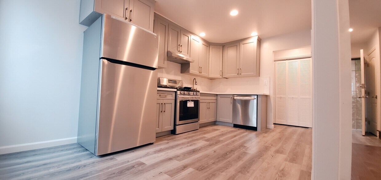
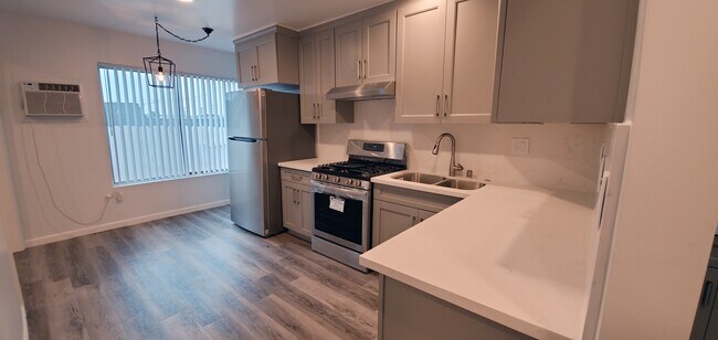
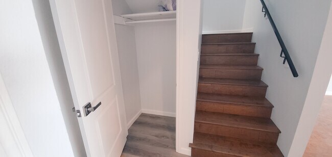
This beautiful remodeled Highland Park Quadflex Unit with a Private Balcony is located in the coveted Hermon District community. Centrally located to the 110 Fwy, w/ numerous hiking trails, E Debs Park, scenic bike lanes, a dog park, the Metro Gold Line, and many notable restaurants and cafes such as Donut Friend, Cafe Birdie, and Kitchen Mouse to name a few. This amazing newly remodeled 2 bedrooms 1.5 bath unit includes a large & bright living room with showering natural light and exquisite laminated floors throughout. Just off the living room is the updated kitchen featuring brand new appliances, tile backsplash, quartz countertops, and ample cabinet space with stainless steel stove, and dishwasher. Additional features include a private enclosed balcony oasis with a private place.
5180 Via Marisol Via is an apartment community located in Los Angeles County and the 90042 ZIP Code.
Apartment Features
Washer/Dryer
Air Conditioning
Dishwasher
Washer/Dryer Hookup
- Washer/Dryer
- Washer/Dryer Hookup
- Air Conditioning
- Smoke Free
- Dishwasher
- Kitchen
- Laundry Facilities
- Balcony
Location
Get Directions
A quiet suburb outside of Los Angeles, Monterey Hills is known for its rolling hills, winding residential streets, and elevated city views. Check out Elephant Hill, a popular place to bike or hike that offers beautiful views of the neighborhood. Herman Park is nestled along Highway 110 in the north end of the neighborhood, offering tennis courts, playgrounds, and a dog park. And for more outdoor recreation, visit the biking paths and hiking trails at Ernest E. Debs Regional Park, bordering Monterey Hills.
Monterey Hills is a more secluded part of Northeast Los Angeles with larger lots, single-family homes, and tree-lined streets. However, if you cross over Highway 110, you’ll find theatres, restaurants, services, and more. Monterey Hills is located just seven miles northeast of Downtown Los Angeles and eight miles east of major attractions such as Griffith Park, the Los Angeles Zoo, the Greek Theatre, and Glendale Galleria.
Learn more about living in Monterey HillsBelow are rent ranges for similar nearby apartments
Amenities
- Washer/Dryer
- Washer/Dryer Hookup
- Air Conditioning
- Smoke Free
- Dishwasher
- Kitchen
- Laundry Facilities
- Balcony
Expenses
Utilities Included
Water
Included
Education
| Colleges & Universities | Distance | ||
|---|---|---|---|
| Colleges & Universities | Distance | ||
| Drive: | 8 min | 3.3 mi | |
| Drive: | 6 min | 3.7 mi | |
| Drive: | 9 min | 4.2 mi | |
| Drive: | 12 min | 4.7 mi |
5180 Via Marisol Via Unit 2 is within 8 minutes or 3.3 miles from Occidental College. It is also near Art Center College of Design and Cal State Los Angeles.
Transportation options available in Los Angeles include Highland Park Station, located 1.1 miles from 5180 Via Marisol Via Unit 2. 5180 Via Marisol Via Unit 2 is near Bob Hope, located 17.6 miles or 25 minutes away, and Los Angeles International, located 20.6 miles or 33 minutes away.
| Transit / Subway | Distance | ||
|---|---|---|---|
| Transit / Subway | Distance | ||
|
|
Drive: | 3 min | 1.1 mi |
|
|
Drive: | 5 min | 2.3 mi |
|
|
Drive: | 6 min | 2.6 mi |
|
|
Drive: | 5 min | 2.7 mi |
|
|
Drive: | 6 min | 3.3 mi |
| Commuter Rail | Distance | ||
|---|---|---|---|
| Commuter Rail | Distance | ||
|
|
Drive: | 10 min | 5.5 mi |
|
|
Drive: | 12 min | 5.6 mi |
|
|
Drive: | 11 min | 6.8 mi |
| Drive: | 14 min | 9.6 mi | |
|
|
Drive: | 22 min | 13.9 mi |
| Airports | Distance | ||
|---|---|---|---|
| Airports | Distance | ||
|
Bob Hope
|
Drive: | 25 min | 17.6 mi |
|
Los Angeles International
|
Drive: | 33 min | 20.6 mi |
Time and distance from 5180 Via Marisol Via Unit 2.
| Shopping Centers | Distance | ||
|---|---|---|---|
| Shopping Centers | Distance | ||
| Walk: | 17 min | 0.9 mi | |
| Drive: | 4 min | 1.4 mi | |
| Drive: | 4 min | 1.6 mi |
5180 Via Marisol Via Unit 2 has 3 shopping centers within 1.6 miles, which is about a 4-minute walk. The miles and minutes will be for the farthest away property.
| Parks and Recreation | Distance | ||
|---|---|---|---|
| Parks and Recreation | Distance | ||
|
Audubon Center at Debs Park
|
Drive: | 4 min | 1.6 mi |
|
Kidspace Children's Museum
|
Drive: | 11 min | 5.2 mi |
|
Elysian Park
|
Drive: | 12 min | 5.3 mi |
|
Elyria Canyon Park
|
Drive: | 11 min | 5.6 mi |
|
Marsh Park
|
Drive: | 11 min | 5.9 mi |
5180 Via Marisol Via Unit 2 has 5 parks within 5.9 miles, including Audubon Center at Debs Park, Elyria Canyon Park, and Kidspace Children's Museum.
| Hospitals | Distance | ||
|---|---|---|---|
| Hospitals | Distance | ||
| Drive: | 8 min | 3.9 mi | |
| Drive: | 10 min | 4.1 mi | |
| Drive: | 7 min | 4.1 mi |
5180 Via Marisol Via Unit 2 has 3 hospitals within 4.1 miles, the nearest is Keck Hospital of USC which is 3.9 miles away and a 8 minute drive.
| Military Bases | Distance | ||
|---|---|---|---|
| Military Bases | Distance | ||
| Drive: | 30 min | 22.2 mi | |
| Drive: | 43 min | 29.6 mi |
5180 Via Marisol Via Unit 2 is 22.2 miles from Los Angeles Air Force Base, and is convenient to other military bases, including Los Alamitos Army Airfield.
You May Also Like
Similar Rentals Nearby


 - Violet on Virgil")


 - AVA Burbank")


What Are Walk Score®, Transit Score®, and Bike Score® Ratings?
Walk Score® measures the walkability of any address. Transit Score® measures access to public transit. Bike Score® measures the bikeability of any address.
What is a Sound Score Rating?
A Sound Score Rating aggregates noise caused by vehicle traffic, airplane traffic and local sources

5180 Via Marisol Via
Los Angeles, CA 90042