
$2,500
/ Month
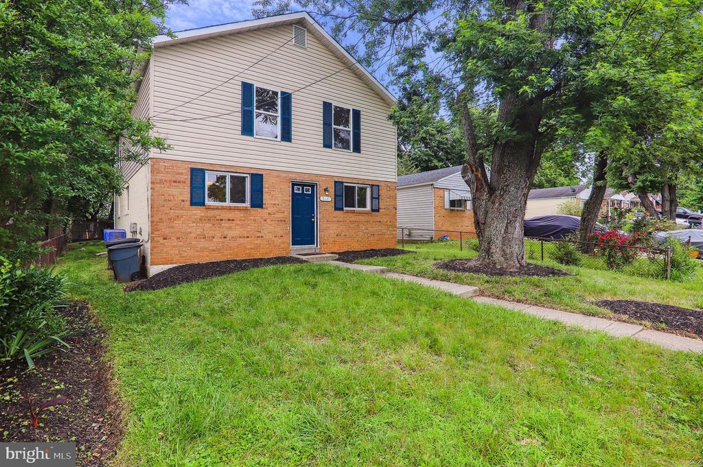
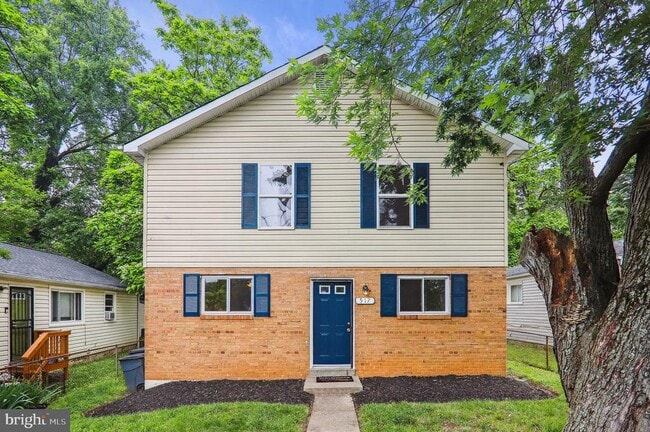
517 Carmody Hills Dr
Capitol Heights, MD 20743
Today
Favorites
703-517-1828
-
Bedrooms
5
-
Bathrooms
3
-
Square Feet
--
-
Available
Available Now
Highlights
- More Than Two Accessible Exits
- Bungalow
- 90% Forced Air Heating and Cooling System
- Ceiling Fan
- Property is in very good condition
517 Carmody Hills Dr

Favorites
About This Home
Available Now
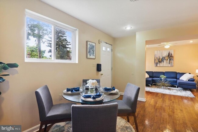
Don’t miss this opportunity! 5 bedroom/3 bathroom in wonderful Carmody Hills Neighborhood of Seat Pleasant. 5 spacious bedrooms to include enormous primary bedroom with ensuite full bathroom. Carpet in bedrooms/ceiling fans and freshly painted throughout. This original bunglalow was expanded in 2006 doubling its size (the top floor which houses 3 bedrooms and 2 fulls baths was new in 2006). Kitchen with granite and stainless steel appliances. 2 bedrooms on main level; use as bedrooms or use one as a den/ living room. kitchen can be expanded into dining space and living room could then be your dining room (endless possibilities). Great location convenient to shopping and transportation. No negative credit (late payments, evictions, etc) and a minimum income of $90k. Please, no pets
517 Carmody Hills Dr is a house located in Prince George's County and the 20743 ZIP Code. This area is served by the Prince George's County Public Schools attendance zone.
* Price shown is base rent and may not include non-optional fees and utilities. Price, availability, fees, and any applicable rent special are subject to change without notice.
* Square footage definitions vary. Displayed square footage is approximate.
Home Details
Home Type
Single Family Detached Home
Year Built
Built in 1961 | Remodeled in 2006
Accessible Home Design
More Than Two Accessible Exits
Bedrooms and Bathrooms
5 Bedrooms | 2 Main Level Bedrooms
3 Full Bathrooms
Home Design
Bungalow
Asphalt Roof
Slab Foundation
Frame Construction
Interior Spaces
Ceiling Fan
1,836 Sq Ft Home
Property has 2 Levels
Laundry
Laundry on main level
Listing and Financial Details
Security Deposit $2,750
12-Month Min and 36-Month Max Lease Term
Available 7/15/25
$50 Application Fee
Assessor Parcel Number 17182019198
Tenant pays for cable TV, electricity, exterior maintenance, frozen waterpipe damage, gas, gutter cleaning, heat, hot water, HVAC maintenance, insurance, lawn/tree/shrub care, light bulbs/filters/fuses/alarm care, minor interior maintenance, sewer, snow removal, trash removal, all utilities, water
No Smoking Allowed
Residential Lease
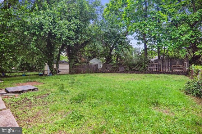
Lot Details
4,460 Sq Ft Lot
Property is in very good condition
Parking
On-Street Parking
Utilities
90% Forced Air Heating and Cooling System
Natural Gas Water Heater
Community Details
Overview
No Home Owners Association
Carmody Hills Subdivision
Pet Policy
No Pets Allowed
Contact
- Listed by Carol L Manning | eXp Realty, LLC
- Phone Number
- Contact
-
Source
 Bright MLS, Inc.
Copyright © 2025 Bright MLS, Inc.
Location
Get Directions
Capitol Heights -- named for its location near Washington, DC -- provides the perfect location: near DC, near the Capital Beltway, and minutes away from FedEx Field, home of the NFL's Washington Football Team. It is also close to the Anacostia River, the United States National Arboretum, and Joint Base Anacostia-Bolling. Nearby Fort Circle Park provides Capitol Heights residents with 10 miles of hiking trails -- it is also a popular concert venue and is home to Fort Dupont Ice Rink.
Capitol Heights is a terrific location for your DC-area apartment, only about seven miles southeast of downtown. Hop on the Metro at the Capitol Heights Metro Station for a fast, car-free commute. Despite being so close to the historic sites of DC, Capitol Heights was a rural area with no paved roads or streetlights. In 1910, the 200 residents in the area named their town "Capitol Heights," but it wasn't until 1980 and the arrival of the Metro Blue Line that the town began to grow.
Learn more about living in Capitol Heights
Education
| Colleges & Universities | Distance | ||
|---|---|---|---|
| Colleges & Universities | Distance | ||
| Drive: | 9 min | 4.6 mi | |
| Drive: | 11 min | 5.3 mi | |
| Drive: | 13 min | 6.4 mi | |
| Drive: | 15 min | 7.9 mi |
517 Carmody Hills Dr is within 9 minutes or 4.6 miles from Univ. of Md. Univ. Coll.. It is also near Prince George's Comm. Coll. and Gallaudet University.
Schools


Public Elementary School
Grades PK-5
443 Students
Attendance Zone
Public Middle School
Grades 6-8
867 Students
Attendance Zone
Public High School
Grades 9-12
1,039 Students
Attendance Zone
Private Elementary & Middle School
Grades PK-8
222 Students
Nearby
Private High School
Grades 9-12
Nearby
School data provided by
 The GreatSchools Rating helps parents compare schools within a state based on a variety of school quality indicators and provides a helpful picture of how effectively each school serves all of its students. Ratings are on a scale of 1 (below average) to 10 (above average) and can include test scores, college readiness, academic progress, advanced courses, equity, discipline and attendance data. We also advise parents to visit schools, consider other information on school performance and programs, and consider family needs as part of the school selection process.
View GreatSchools Rating Methodology
Data provided by GreatSchools.org © 2025. All rights reserved.
View GreatSchools Rating Methodology
Data provided by GreatSchools.org © 2025. All rights reserved.
Transportation options available in Capitol Heights include Capitol Heights, Blue/Silver Line Center Platform, located 1.7 miles from 517 Carmody Hills Dr. 517 Carmody Hills Dr is near Ronald Reagan Washington Ntl, located 12.8 miles or 23 minutes away, and Baltimore/Washington International Thurgood Marshall, located 29.1 miles or 44 minutes away.
| Transit / Subway | Distance | ||
|---|---|---|---|
| Transit / Subway | Distance | ||
|
Capitol Heights, Blue/Silver Line Center Platform
|
Drive: | 4 min | 1.7 mi |
|
|
Drive: | 3 min | 1.7 mi |
|
|
Drive: | 8 min | 2.6 mi |
|
|
Drive: | 6 min | 2.8 mi |
|
|
Drive: | 8 min | 3.4 mi |
| Commuter Rail | Distance | ||
|---|---|---|---|
| Commuter Rail | Distance | ||
|
|
Drive: | 14 min | 6.9 mi |
| Drive: | 14 min | 7.3 mi | |
|
|
Drive: | 14 min | 7.3 mi |
| Drive: | 17 min | 8.1 mi | |
| Drive: | 17 min | 8.3 mi |
| Airports | Distance | ||
|---|---|---|---|
| Airports | Distance | ||
|
Ronald Reagan Washington Ntl
|
Drive: | 23 min | 12.8 mi |
|
Baltimore/Washington International Thurgood Marshall
|
Drive: | 44 min | 29.1 mi |
Time and distance from 517 Carmody Hills Dr.
| Shopping Centers | Distance | ||
|---|---|---|---|
| Shopping Centers | Distance | ||
| Walk: | 14 min | 0.8 mi | |
| Drive: | 4 min | 1.6 mi | |
| Drive: | 4 min | 1.8 mi |
517 Carmody Hills Dr has 3 shopping centers within 1.8 miles, which is about a 4-minute walk. The miles and minutes will be for the farthest away property.
| Parks and Recreation | Distance | ||
|---|---|---|---|
| Parks and Recreation | Distance | ||
|
Fort Dupont Park
|
Drive: | 10 min | 3.9 mi |
|
Walker Mill Regional Park
|
Drive: | 8 min | 4.4 mi |
|
Kingman and Heritage Island Park
|
Drive: | 9 min | 4.6 mi |
|
Bladensburg Waterfront Park
|
Drive: | 9 min | 5.0 mi |
|
National Arboretum
|
Drive: | 13 min | 6.5 mi |
517 Carmody Hills Dr has 5 parks within 6.5 miles, including Walker Mill Regional Park, Fort Dupont Park, and Kingman and Heritage Island Park.
| Hospitals | Distance | ||
|---|---|---|---|
| Hospitals | Distance | ||
| Drive: | 9 min | 4.3 mi | |
| Drive: | 17 min | 7.1 mi | |
| Drive: | 17 min | 7.2 mi |
517 Carmody Hills Dr has 3 hospitals within 7.2 miles, the nearest is University of Maryland Prince George's Hospital Center which is 4.3 miles away and a 9 minute drive.
| Military Bases | Distance | ||
|---|---|---|---|
| Military Bases | Distance | ||
| Drive: | 14 min | 6.8 mi | |
| Drive: | 17 min | 8.3 mi |
517 Carmody Hills Dr is 6.8 miles from Washington Navy Yard, and is convenient to other military bases, including Andrews Airforce Base.
You May Also Like
Similar Rentals Nearby


What Are Walk Score®, Transit Score®, and Bike Score® Ratings?
Walk Score® measures the walkability of any address. Transit Score® measures access to public transit. Bike Score® measures the bikeability of any address.
What is a Sound Score Rating?
A Sound Score Rating aggregates noise caused by vehicle traffic, airplane traffic and local sources

517 Carmody Hills Dr
Capitol Heights, MD 20743