
$4,200
Total Monthly Price
51 Robey St
Boston, MA 02119
Today
Favorites
617-620-3472
-
Bedrooms
3
-
Bathrooms
2.5
-
Square Feet
1,410 sq ft
-
Available
Available Now
Highlights
- Medical Services
- Property is near public transit
- 2 Fireplaces
- Fenced Yard
- Enclosed Patio or Porch
- No Cooling
51 Robey St

Favorites
About This Home
$4,200 deposit,
Available Now
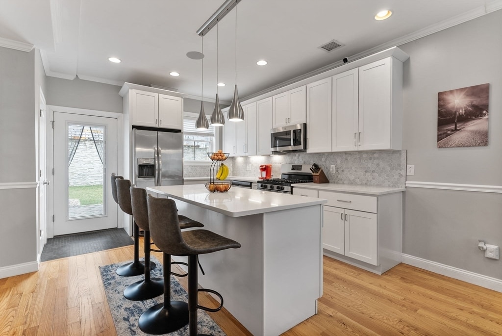
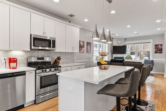
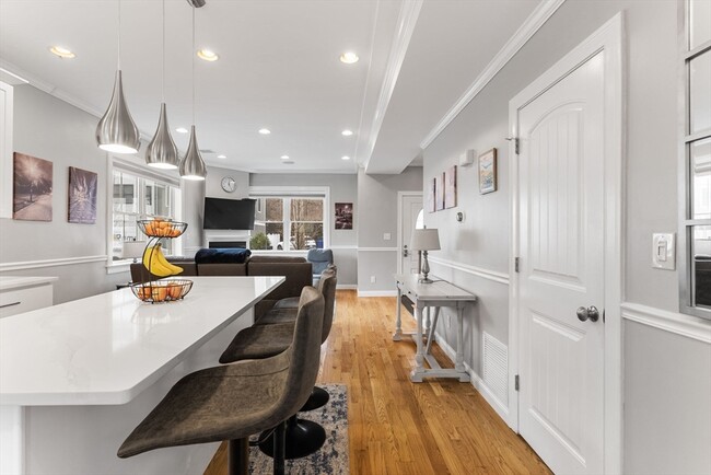
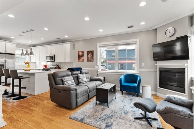
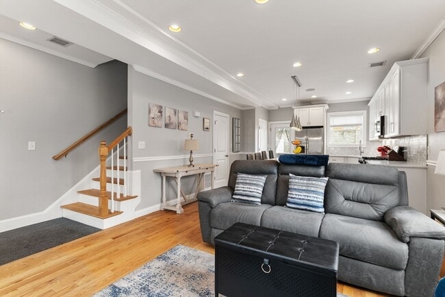
This spacious and stylish townhome,built in 2018,offers three levels of modern living in a peaceful,two-unit association. Tucked away on a quiet street,yet just minutes from downtown Boston & less than a quarter mile from the commuter rail train station. This unit provides the perfect balance of convenience and tranquility. The generous fenced yard with patio and a paved driveway with 2 off-street parking spots enhance its appeal,while the open floor plan and direct access to private outdoor space make hosting effortless. The gourmet kitchen offers stainless steel appliances,quartz countertops,a large island and opens into the living room with a built-in gas fireplace. The top-level primary suite boasts a stunning bath,an expansive custom-designed closet and an additional built-in gas fireplace. A half bath on the first floor is perfect for guests,while a full bath on the second level offers privacy. This unit is available now or for a 9/1 move in. MLS# 73403712
51 Robey St is a townhome located in Suffolk County and the 02119 ZIP Code. This area is served by the Boston Public Schools attendance zone.
* Price shown is total price including community-supplied monthly required fees. Price, availability, fees, and any applicable rent special are subject to change without notice.
* Square footage definitions vary. Displayed square footage is approximate.
Home Details
Year Built
Built in 2018
Accessible Home Design
Entry on the 1st floor
Bedrooms and Bathrooms
2.5 Bathrooms
3 Bedrooms
Home Design
Property Attached
Interior Spaces
2 Fireplaces
1,410 Sq Ft Home
Kitchen
Range
Freezer
Microwave
Dishwasher
Disposal
Laundry
Dryer
Laundry in unit
Washer
Listing and Financial Details
Security Deposit $4,200
12 Month Lease Term
Assessor Parcel Number 3325108
Rent includes water, sewer
Location
Property is near public transit
Lot Details
Fenced Yard
Outdoor Features
Enclosed Patio or Porch
Parking
2 Car Parking Spaces
Utilities
No Cooling
Forced Air Heating System
Heating System Uses Natural Gas
Community Details
Amenities
Medical Services
Shops
Overview
Property has a Home Owners Association
Pet Policy
No Pets Allowed
Recreation
Park
Fees and Policies
The fees below are based on community-supplied data and may exclude additional fees and utilities.
Contact
- Listed by Joe Parrish | EVO Real Estate Group,LLC
- Phone Number
-
Source
 MLS Property Information Network
The property listing data and information set forth herein were provided to MLS Property Information Network, Inc. from third party sources, including sellers, lessors and public records, and were compiled by MLS Property Information Network, Inc. The property listing data and information are for the personal, non-commercial use of consumers having a good faith interest in purchasing or leasing listed properties of the type displayed to them and may not be used for any purpose other than to identify prospective properties which such consumers may have a good faith interest in purchasing or leasing. MLS Property Information Network, Inc. and its subscribers disclaim any and all representations and warranties as to the accuracy of the property listing data and information set forth herein. All properties are subject to prior sale, change or withdrawal. Copyright © 2025 MLS Property Information Network, Inc. All rights reserved.
Location
Get Directions
Amenities
- Dishwasher
- Disposal
- Microwave
- Range
- Refrigerator
- Freezer
- Fenced Lot
- Patio
Less than four miles outside of Downtown Boston sits Dudley-Brunswick King. Full of non-profit organizations committed to advancing the community, Dudley-Brunswick King is home to the Food Project, CommonWealth Kitchen, Project Hope, and the Dudley Street Neighborhood Initiative.
Dudley-Brunswick King residents enjoy access to cultural and educational venues such as the Boston Public Library and Oodua African Movie Center. There are a number of parks and green spaces in Dudley-Brunswick King including Clifford Playground, Mary Hannon Park, Ceylon Park, Brunswick-King Play Area, Dacia/Woodcliff Streets Garden, and multiple community gardens sponsored by the Food Project. Boston’s biggest park, Franklin Park, is also nearby and contains numerous amenities.
Convenient to the MBTA Commuter Rail, bus routes, and major highways as well as Boston Logan International Airport, Dudley-Brunswick King allows for easy commutes and travels.
Learn more about living in Dudley-Brunswick King
Education
| Colleges & Universities | Distance | ||
|---|---|---|---|
| Colleges & Universities | Distance | ||
| Drive: | 6 min | 2.0 mi | |
| Drive: | 5 min | 2.2 mi | |
| Drive: | 6 min | 2.3 mi | |
| Drive: | 5 min | 2.5 mi |
51 Robey St is within 6 minutes or 2.3 miles from Northeastern University. It is also near UMass Boston and Wentworth Inst. of Technology.
Schools


Public Elementary School
Grades PK-5
188 Students
Attendance Zone
Charter Elementary School
Grades PK-5
278 Students
Attendance Zone
Public Middle & High School
Grades 7-12
420 Students
Attendance Zone
Public Middle School
Grades 6-8
323 Students
Attendance Zone
Public Middle & High School
Grades 7-12
1,723 Students
Attendance Zone
Charter High School
Grades 9-10 & 12
321 Students
Attendance Zone
Private Elementary School
Grades PK-6
128 Students
Nearby
Private Middle School
Grades 7-9
Nearby
Private High School
Grades 9-12
270 Students
Nearby
School data provided by
 The GreatSchools Rating helps parents compare schools within a state based on a variety of school quality indicators and provides a helpful picture of how effectively each school serves all of its students. Ratings are on a scale of 1 (below average) to 10 (above average) and can include test scores, college readiness, academic progress, advanced courses, equity, discipline and attendance data. We also advise parents to visit schools, consider other information on school performance and programs, and consider family needs as part of the school selection process.
View GreatSchools Rating Methodology
Data provided by GreatSchools.org © 2025. All rights reserved.
View GreatSchools Rating Methodology
Data provided by GreatSchools.org © 2025. All rights reserved.
Transportation options available in Boston include Andrew Station, located 1.2 miles from 51 Robey St. 51 Robey St is near General Edward Lawrence Logan International, located 6.1 miles or 12 minutes away.
| Transit / Subway | Distance | ||
|---|---|---|---|
| Transit / Subway | Distance | ||
|
|
Drive: | 2 min | 1.2 mi |
|
|
Drive: | 3 min | 1.7 mi |
|
|
Drive: | 3 min | 1.8 mi |
|
|
Drive: | 5 min | 2.2 mi |
|
|
Drive: | 6 min | 2.2 mi |
| Commuter Rail | Distance | ||
|---|---|---|---|
| Commuter Rail | Distance | ||
|
|
Walk: | 9 min | 0.5 mi |
| Walk: | 10 min | 0.5 mi | |
|
|
Drive: | 4 min | 1.4 mi |
| Drive: | 4 min | 1.9 mi | |
|
|
Drive: | 6 min | 2.7 mi |
| Airports | Distance | ||
|---|---|---|---|
| Airports | Distance | ||
|
General Edward Lawrence Logan International
|
Drive: | 12 min | 6.1 mi |
Time and distance from 51 Robey St.
| Shopping Centers | Distance | ||
|---|---|---|---|
| Shopping Centers | Distance | ||
| Walk: | 14 min | 0.8 mi | |
| Walk: | 18 min | 0.9 mi | |
| Drive: | 4 min | 1.4 mi |
51 Robey St has 3 shopping centers within 1.4 miles, which is about a 4-minute walk. The miles and minutes will be for the farthest away property.
| Parks and Recreation | Distance | ||
|---|---|---|---|
| Parks and Recreation | Distance | ||
|
Roxbury Heritage State Park
|
Drive: | 3 min | 1.5 mi |
|
Lower Neponset River Trail
|
Drive: | 4 min | 1.6 mi |
|
Dorchester Shores Reservation
|
Drive: | 5 min | 2.1 mi |
|
Franklin Park Zoo
|
Drive: | 4 min | 2.2 mi |
|
Boston Public Garden
|
Drive: | 8 min | 3.5 mi |
51 Robey St has 5 parks within 3.5 miles, including Roxbury Heritage State Park, Lower Neponset River Trail, and Franklin Park Zoo.
| Hospitals | Distance | ||
|---|---|---|---|
| Hospitals | Distance | ||
| Drive: | 3 min | 1.3 mi | |
| Drive: | 3 min | 1.5 mi | |
| Drive: | 6 min | 2.9 mi |
51 Robey St has 3 hospitals within 2.9 miles, the nearest is Boston Medical Center which is 1.3 miles away and a 3 minute drive.
You May Also Like
Similar Rentals Nearby
-
-

-

-

-

-
 $3,600Total Monthly Price12 Month Lease3 Beds, 1.5 Baths, 1,350 sq ftTownhome for Rent
 -
 $4,400Total Monthly Price12 Month Lease4 Beds, 1 Bath, 1,576 sq ftTownhome for Rent
 -
 $4,700 - $5,600Total Monthly Price12 Month Lease3-4 Beds, 1-2 BathsTownhome for Rent
 -
 $5,900Total Monthly Price12 Month Lease4 Beds, 2 Baths, 1,600 sq ftTownhome for Rent
 -
 $1,275Total Monthly Price12 Month Lease4 Beds, 2 Baths, 2,000 sq ftTownhome for Rent
What Are Walk Score®, Transit Score®, and Bike Score® Ratings?
Walk Score® measures the walkability of any address. Transit Score® measures access to public transit. Bike Score® measures the bikeability of any address.
What is a Sound Score Rating?
A Sound Score Rating aggregates noise caused by vehicle traffic, airplane traffic and local sources

51 Robey St
Boston, MA 02119