
The Vitagraph
1277 E 14th St,
Brooklyn, NY 11230
$2,770 - $3,668
1-3 Beds
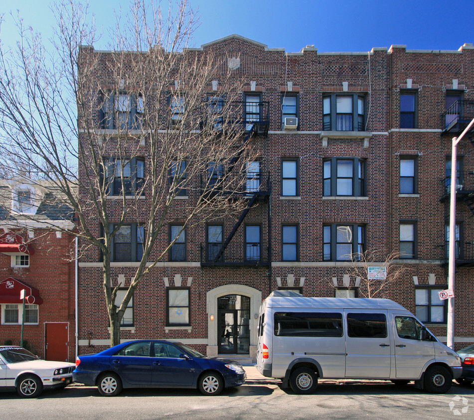
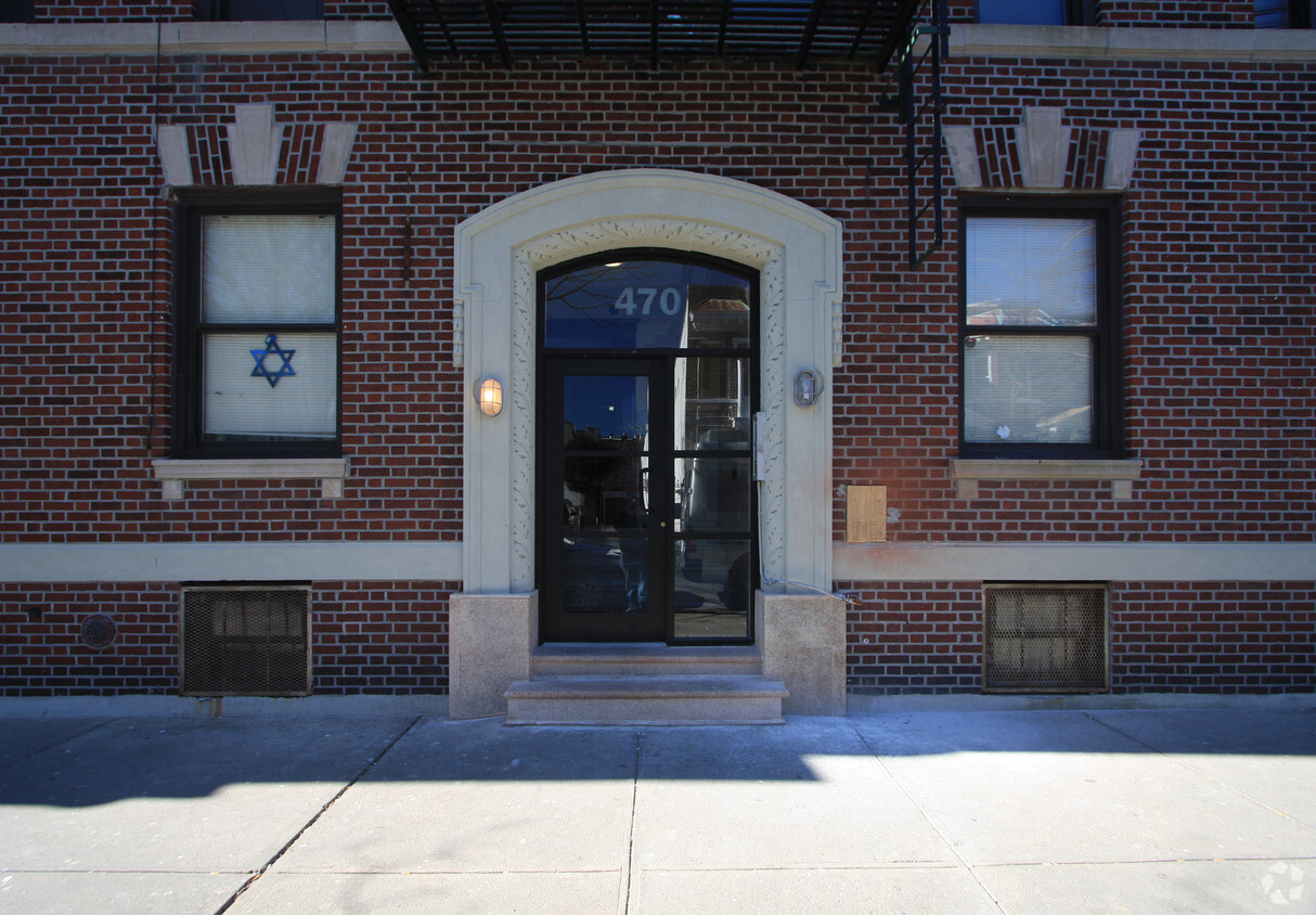

At 470 76th St, you've discovered your new home. The premium 76th St. address in the 11209 Zip code of Brooklyn is a great place for you. The leasing staff is ready and waiting to help you find the perfect place. Come for a visit to see the current floorplan options. Contact us or drop by to talk about leasing your new apartment and find your new place at 470 76th St.
470 76th St is an apartment community located in Kings County and the 11209 ZIP Code. This area is served by the New York City Geographic District #20 attendance zone.
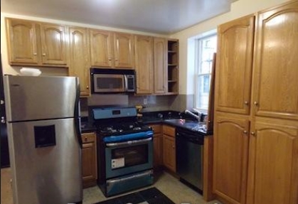
Washer/Dryer Hookup
Hardwood Floors
Oven
Range
Bay Ridge’s name can be taken quite literally, seeing as the neighborhood is situated on the ridge of New York’s Upper Bay in the bustling borough of Brooklyn. This urban, coastal oasis is known for its picturesque residential streets and slight seclusion from big city living.
Though Bay Ridge is an urban neighborhood, many residents applaud this coastal town for its ability to offer a suburban vibe and family-friendly atmosphere amidst its New York City location. Apartments, houses, condos, and townhomes range from cozy to luxury, so there’s something for everyone in this welcoming community.
Towering trees line the residential and commercial streets of Bay Ridge, giving it a park-like feel. And speaking of parks, this neighborhood’s entire coastline is covered by community parks featuring waterfront lawns, tall trees, and recreational amenities.
Learn more about living in Bay RidgeCompare neighborhood and city base rent averages by bedroom.
| Bay Ridge | Brooklyn, NY | |
|---|---|---|
| Studio | $1,409 | $2,674 |
| 1 Bedroom | $1,820 | $2,996 |
| 2 Bedrooms | $2,089 | $3,925 |
| 3 Bedrooms | $2,536 | $4,864 |
| Colleges & Universities | Distance | ||
|---|---|---|---|
| Colleges & Universities | Distance | ||
| Drive: | 15 min | 5.7 mi | |
| Drive: | 11 min | 5.8 mi | |
| Drive: | 15 min | 5.9 mi | |
| Drive: | 13 min | 5.9 mi |


Transportation options available in Brooklyn include 77 Street (R Line), located 0.1 mile from 470 76th St. 470 76th St is near Newark Liberty International, located 20.2 miles or 32 minutes away, and John F Kennedy International, located 21.0 miles or 30 minutes away.
| Transit / Subway | Distance | ||
|---|---|---|---|
| Transit / Subway | Distance | ||
|
|
Walk: | 2 min | 0.1 mi |
|
|
Walk: | 9 min | 0.5 mi |
|
|
Walk: | 12 min | 0.6 mi |
|
|
Drive: | 4 min | 1.3 mi |
|
|
Drive: | 4 min | 1.5 mi |
| Commuter Rail | Distance | ||
|---|---|---|---|
| Commuter Rail | Distance | ||
|
|
Drive: | 10 min | 5.2 mi |
|
|
Drive: | 11 min | 5.6 mi |
|
|
Drive: | 13 min | 6.2 mi |
|
|
Drive: | 15 min | 6.8 mi |
|
|
Drive: | 18 min | 7.4 mi |
| Airports | Distance | ||
|---|---|---|---|
| Airports | Distance | ||
|
Newark Liberty International
|
Drive: | 32 min | 20.2 mi |
|
John F Kennedy International
|
Drive: | 30 min | 21.0 mi |
Scores provided by
Traffic
-Airport
-Businesses
-Scores provided by
HowLoud What is a Sound Score Rating? A Sound Score Rating aggregates noise caused by vehicle traffic, airplane traffic and local sources. How It WorksTime and distance from 470 76th St.
| Shopping Centers | Distance | ||
|---|---|---|---|
| Shopping Centers | Distance | ||
| Walk: | 11 min | 0.6 mi | |
| Drive: | 3 min | 1.1 mi | |
| Drive: | 6 min | 2.3 mi |
| Parks and Recreation | Distance | ||
|---|---|---|---|
| Parks and Recreation | Distance | ||
|
Owl's Head Park
|
Drive: | 3 min | 1.4 mi |
|
Dyker Beach Park
|
Drive: | 3 min | 1.5 mi |
|
Sunset Park
|
Drive: | 6 min | 2.8 mi |
|
Narrows Botanical Gardens
|
Drive: | 7 min | 3.5 mi |
|
Alice Austen Park
|
Drive: | 10 min | 5.2 mi |
| Hospitals | Distance | ||
|---|---|---|---|
| Hospitals | Distance | ||
| Drive: | 6 min | 2.4 mi | |
| Drive: | 11 min | 4.6 mi | |
| Drive: | 12 min | 5.5 mi |
| Military Bases | Distance | ||
|---|---|---|---|
| Military Bases | Distance | ||
| Drive: | 6 min | 2.1 mi | |
| Drive: | 14 min | 6.4 mi |
What Are Walk Score®, Transit Score®, and Bike Score® Ratings?
Walk Score® measures the walkability of any address. Transit Score® measures access to public transit. Bike Score® measures the bikeability of any address.
What is a Sound Score Rating?
A Sound Score Rating aggregates noise caused by vehicle traffic, airplane traffic and local sources.


