
$1,865 / Month
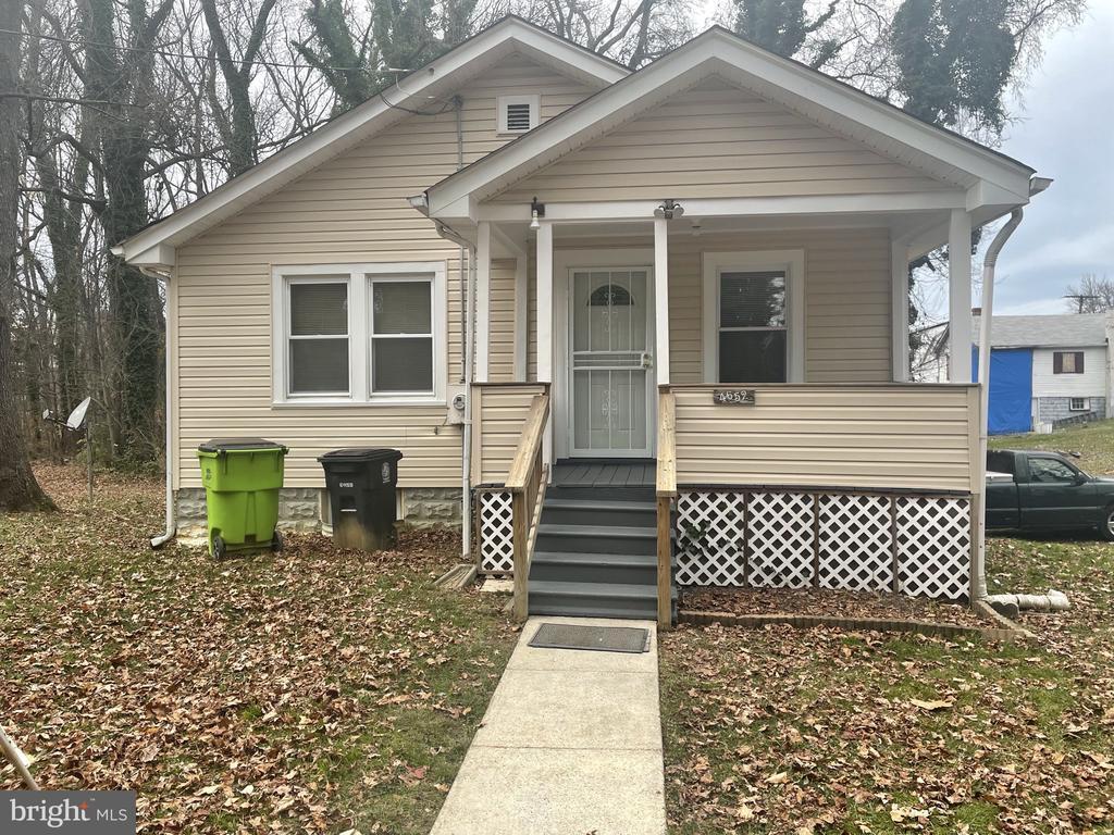
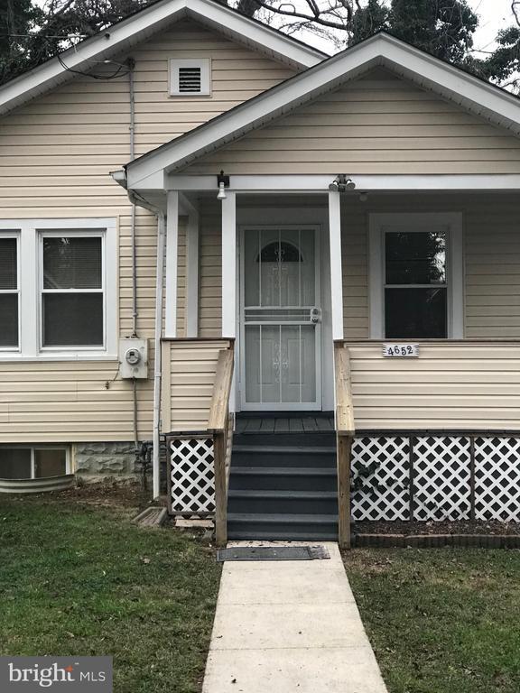
4652 Bennett Ave
Hillcrest Heights, MD 20746
Today
Favorites
301-412-8097
-
Bedrooms
2
-
Bathrooms
1
-
Square Feet
925 sq ft
-
Available
Available Now
Highlights
- View of Trees or Woods
- Private Lot
- Partially Wooded Lot
- Porch
- Bungalow
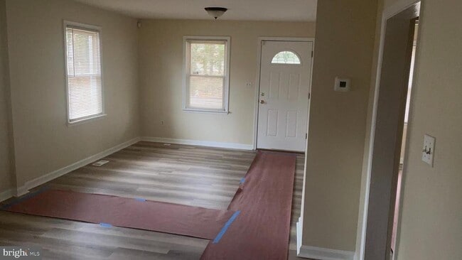
- Luxury Vinyl Plank Tile Flooring
4652 Bennett Ave

Favorites
About This Home
Available Now
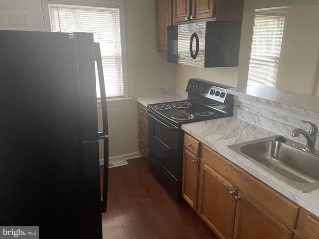
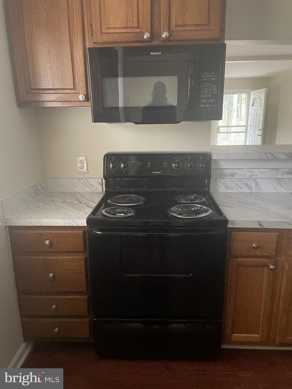
Very nice 2 Bedroom, 1 bath home located off a private road. Majority of the house was renovated in 2023. Updated Electric Range, Countertops, and bathroom; area off kitchen could be used as pantry, etc. - Front porch facing trees. All updated LVT flooring. Property located in wooded area near the D.C. line (Off Shadyside Avenue). Parking at front door. Bus Stop nearby.
4652 Bennett Ave is a house located in Prince George's County and the 20746 ZIP Code. This area is served by the Prince George's County Public Schools attendance zone.
* Price shown is base rent and may not include non-optional fees and utilities.
Price, availability, fees, and any applicable rent special are subject to change without notice.
* Square footage definitions vary. Displayed square footage is approximate.
Home Details
Home Type
Single Family Detached Home
Year Built
Built in 1935 | Remodeled in 2023
Accessible Home Design
Entry on the 1st floor
Bedrooms and Bathrooms
2 Main Level Bedrooms
1 Full Bathroom
Home Design
Bungalow
Vinyl Siding
Poured Concrete
Interior Spaces
Luxury Vinyl Plank Tile Flooring
Combination Dining and Living Room
Window Screens
925 Sq Ft Home
Property has 1 Level
Kitchen
Electric Oven or Range
Microwave
Disposal
Listing and Financial Details
Security Deposit $1,865
Requires 1 Month of Rent Paid Up Front
12-Month Lease Term
Available 8/1/25
$40 Application Fee
Assessor Parcel Number 17060506949
Tenant pays for electricity, gas, heat, hot water, insurance, internet, lawn/tree/shrub care, light bulbs/filters/fuses/alarm care, minor interior maintenance, all utilities
The owner pays for common area maintenance, management, real estate taxes, insurance
Rent includes parking
No Smoking Allowed
Residential Lease
Lot Details
2.83 Acre Lot
Private Lot
Partially Wooded Lot
Corner Lot
Property is in very good condition
Front Yard
No Through Street
Backs To Open Common Area
Property is zoned R10A
Outdoor Features
Porch
Parking
Private Parking
Off-Street Parking
Schools
Suitland High School
Unfinished Basement
Interior and Exterior Basement Entry
Utilities
Central Heating and Cooling System
Natural Gas Water Heater
Vented Exhaust Fan
Views
Views of Woods
Community Details
Overview
No Home Owners Association
Property Manager
Bradbury Subdivision
Pet Policy
No Pets Allowed
Contact
- Listed by Cassandra A Williams | Keller Williams Preferred Properties
- Phone Number
- Contact
-
Source
 Bright MLS, Inc.
Copyright © 2025 Bright MLS, Inc.
Location
Get Directions
Amenities
- Basement
Hillcrest Heights is located in Prince George County, just southeast of Washington D.C., across the Anacostia River. Hillcrest Heights' location to the Capital provides a variety of unique shopping destinations, international and local cuisines, and cool sites to see! The Shops at Iverson are located inside Hillcrest Heights, and nearby you’ll discover Phoenix Theatres-Marlow 6, Marlow Heights Shopping Center, plus dine-in and quick-bite restaurants.
Thanks to close proximity to I-495 and I-295, residents can travel with ease to Virginia, Washington D.C., and Maryland. The Metro subway is also a suitable commuting option, since convenient train access points are stationed at Naylord Road and Southern Avenue. Hillcrest Park and Oxon Run are extensive green spaces in the area, ideal for recreational sports.
Learn more about living in Hillcrest Heights
Education
| Colleges & Universities | Distance | ||
|---|---|---|---|
| Colleges & Universities | Distance | ||
| Drive: | 12 min | 5.9 mi | |
| Drive: | 12 min | 5.9 mi | |
| Drive: | 13 min | 5.9 mi | |
| Drive: | 13 min | 6.5 mi |
4652 Bennett Ave is within 12 minutes or 5.9 miles from Georgetown. It is also near Georgetown Law and Gallaudet University.
Schools


Public Elementary School
Grades PK-6
444 Students
Attendance Zone
Public High School
Grades 9-12
1,834 Students
Attendance Zone
Private Elementary & Middle School
Grades PK-8
156 Students
Nearby
Private Elementary & Middle School
Grades PK-8
130 Students
Nearby
Private Elementary, Middle & High School
Grades PK-12
35 Students
Nearby
School data provided by
 The GreatSchools Rating helps parents compare schools within a state based on a variety of school quality indicators and provides a helpful picture of how effectively each school serves all of its students. Ratings are on a scale of 1 (below average) to 10 (above average) and can include test scores, college readiness, academic progress, advanced courses, equity, discipline and attendance data. We also advise parents to visit schools, consider other information on school performance and programs, and consider family needs as part of the school selection process.
View GreatSchools Rating Methodology
Data provided by GreatSchools.org © 2025. All rights reserved.
View GreatSchools Rating Methodology
Data provided by GreatSchools.org © 2025. All rights reserved.
Transportation options available in Hillcrest Heights include Suitland, located 2.1 miles from 4652 Bennett Ave. 4652 Bennett Ave is near Ronald Reagan Washington Ntl, located 9.5 miles or 19 minutes away, and Baltimore/Washington International Thurgood Marshall, located 30.9 miles or 47 minutes away.
| Transit / Subway | Distance | ||
|---|---|---|---|
| Transit / Subway | Distance | ||
|
|
Drive: | 7 min | 2.1 mi |
|
|
Drive: | 5 min | 2.1 mi |
|
|
Drive: | 6 min | 2.3 mi |
|
Capitol Heights, Blue/Silver Line Center Platform
|
Drive: | 6 min | 2.8 mi |
|
|
Drive: | 8 min | 3.6 mi |
| Commuter Rail | Distance | ||
|---|---|---|---|
| Commuter Rail | Distance | ||
|
|
Drive: | 11 min | 5.5 mi |
|
|
Drive: | 11 min | 5.5 mi |
|
|
Drive: | 12 min | 6.1 mi |
|
|
Drive: | 13 min | 6.3 mi |
|
|
Drive: | 15 min | 8.2 mi |
| Airports | Distance | ||
|---|---|---|---|
| Airports | Distance | ||
|
Ronald Reagan Washington Ntl
|
Drive: | 19 min | 9.5 mi |
|
Baltimore/Washington International Thurgood Marshall
|
Drive: | 47 min | 30.9 mi |
Time and distance from 4652 Bennett Ave.
| Shopping Centers | Distance | ||
|---|---|---|---|
| Shopping Centers | Distance | ||
| Drive: | 2 min | 1.2 mi | |
| Drive: | 3 min | 1.3 mi | |
| Drive: | 3 min | 1.3 mi |
4652 Bennett Ave has 3 shopping centers within 1.3 miles, which is about a 3-minute drive. The miles and minutes will be for the farthest away property.
| Parks and Recreation | Distance | ||
|---|---|---|---|
| Parks and Recreation | Distance | ||
|
Fort Dupont Park
|
Drive: | 5 min | 1.6 mi |
|
Suitland Bog
|
Drive: | 6 min | 3.0 mi |
|
Oxon Cove Park
|
Drive: | 8 min | 3.5 mi |
|
Frederick Douglass National Historic Site
|
Drive: | 9 min | 3.6 mi |
|
Kingman and Heritage Island Park
|
Drive: | 8 min | 4.1 mi |
4652 Bennett Ave has 5 parks within 4.1 miles, including Fort Dupont Park, Suitland Bog, and Oxon Cove Park.
| Hospitals | Distance | ||
|---|---|---|---|
| Hospitals | Distance | ||
| Drive: | 10 min | 4.0 mi | |
| Drive: | 9 min | 4.2 mi | |
| Drive: | 12 min | 6.1 mi |
4652 Bennett Ave has 3 hospitals within 6.1 miles, the nearest is St. Elizabeth's Hospital which is 4.0 miles away and a 10 minute drive.
| Military Bases | Distance | ||
|---|---|---|---|
| Military Bases | Distance | ||
| Drive: | 10 min | 4.3 mi | |
| Drive: | 11 min | 5.1 mi |
4652 Bennett Ave is 4.3 miles from Washington Navy Yard, and is convenient to other military bases, including Anacostia Naval Station.
You May Also Like
Similar Rentals Nearby


What Are Walk Score®, Transit Score®, and Bike Score® Ratings?
Walk Score® measures the walkability of any address. Transit Score® measures access to public transit. Bike Score® measures the bikeability of any address.
What is a Sound Score Rating?
A Sound Score Rating aggregates noise caused by vehicle traffic, airplane traffic and local sources

4652 Bennett Ave
Hillcrest Heights, MD 20746