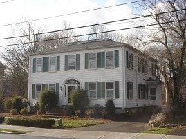
440 N Main St
440 N Main St,
Randolph,
MA
02368
2 Weeks Ago
Favorites
440 N Main St
Favorites
Check Back Soon for Upcoming Availability
| Beds | Baths | Average SF | Availability |
|---|---|---|---|
| 2 Bedrooms 2 Bedrooms 2 Br | 1 Bath 1 Bath 1 Ba | — | Not Available |
Fees and Policies
Details
Property Information
-
Built in 1810
-
5 units/2 stories
About 440 N Main St Randolph, MA 02368
Welcome home to 440 N Main St in Randolph, MA. The location of this community is at 440 N. Main St. in Randolph. Be sure to view the available floorplans. From amenities to floorplan options, the team of leasing professionals is ready to help you find the perfect fit. At 440 N Main St you're home. Stop by the community today.
440 N Main St is an apartment community located in Norfolk County and the 02368 ZIP Code. This area is served by the Randolph attendance zone.
Location
Get Directions
Randolph is a fairly large town, just inland from Quincy and Weymouth on Interstate 93. The drive to Boston is only about 25 minutes and MBTA rail service is available as well, making it a highly convenient location for commuters or folks who just enjoy the occasional jaunt into the city.
The community itself is mainly residential, with clusters of locally-owned shops and restaurants on the north and south ends of Main Street. Goldstein Open Space and Bertha Soule Memorial Park near the center of town provide terrific grounds for getting outdoors and enjoying some fresh air, and the huge nature preserves near the coast are easily within day trip distance.
Learn more about living in Randolph
Education
| Colleges & Universities | Distance | ||
|---|---|---|---|
| Colleges & Universities | Distance | ||
| Drive: | 9 min | 3.7 mi | |
| Drive: | 16 min | 8.3 mi | |
| Drive: | 17 min | 8.4 mi | |
| Drive: | 16 min | 10.1 mi |
440 N Main St is within 9 minutes or 3.7 miles from Massasoit C.C., Canton Campus. It is also near Curry College and Massasoit C.C., Brockton.
Schools


Public Elementary School
Grades K-5
285 Students
Nearby
Public Elementary School
Grades PK-5
420 Students
Attendance Zone
Public Middle School
Grades 6-8
566 Students
Attendance Zone
Public High School
Grades 9-12
619 Students
Attendance Zone
Private Elementary, Middle & High School
158 Students
Nearby
Private Elementary, Middle & High School
Grades PK-12
145 Students
Nearby
School data provided by
 The GreatSchools Rating helps parents compare schools within a state based on a variety of school quality indicators and provides a helpful picture of how effectively each school serves all of its students. Ratings are on a scale of 1 (below average) to 10 (above average) and can include test scores, college readiness, academic progress, advanced courses, equity, discipline and attendance data. We also advise parents to visit schools, consider other information on school performance and programs, and consider family needs as part of the school selection process.
View GreatSchools Rating Methodology
Data provided by GreatSchools.org © 2025. All rights reserved.
View GreatSchools Rating Methodology
Data provided by GreatSchools.org © 2025. All rights reserved.
Transportation options available in Randolph include Braintree Station, located 4.9 miles from 440 N Main St. 440 N Main St is near General Edward Lawrence Logan International, located 17.9 miles or 29 minutes away.
| Transit / Subway | Distance | ||
|---|---|---|---|
| Transit / Subway | Distance | ||
|
|
Drive: | 10 min | 4.9 mi |
|
|
Drive: | 12 min | 6.3 mi |
|
|
Drive: | 13 min | 7.1 mi |
|
|
Drive: | 14 min | 7.4 mi |
|
|
Drive: | 16 min | 8.9 mi |
| Commuter Rail | Distance | ||
|---|---|---|---|
| Commuter Rail | Distance | ||
|
|
Drive: | 4 min | 1.7 mi |
|
|
Drive: | 9 min | 4.7 mi |
|
|
Drive: | 9 min | 4.9 mi |
|
|
Drive: | 9 min | 5.0 mi |
|
|
Drive: | 14 min | 7.0 mi |
| Airports | Distance | ||
|---|---|---|---|
| Airports | Distance | ||
|
General Edward Lawrence Logan International
|
Drive: | 29 min | 17.9 mi |
Time and distance from 440 N Main St.
| Shopping Centers | Distance | ||
|---|---|---|---|
| Shopping Centers | Distance | ||
| Walk: | 10 min | 0.6 mi | |
| Walk: | 13 min | 0.7 mi | |
| Drive: | 2 min | 1.2 mi |
440 N Main St has 3 shopping centers within 1.2 miles, which is about a 2-minute walk. The miles and minutes will be for the farthest away property.
| Parks and Recreation | Distance | ||
|---|---|---|---|
| Parks and Recreation | Distance | ||
|
Ames Nowell State Park
|
Drive: | 10 min | 5.3 mi |
|
Blue Hills Reservation
|
Drive: | 10 min | 5.5 mi |
|
Houghton's Pond Recreation Area
|
Drive: | 10 min | 5.5 mi |
|
Mass Audubon's Mildred Morse Allen Wildlife Sanctuary
|
Drive: | 14 min | 6.5 mi |
|
Mass Audubon's Blue Hills Trailside Museum
|
Drive: | 11 min | 6.5 mi |
440 N Main St has 5 parks within 6.5 miles, including Blue Hills Reservation, Houghton's Pond Recreation Area, and Ames Nowell State Park.
| Hospitals | Distance | ||
|---|---|---|---|
| Hospitals | Distance | ||
| Drive: | 10 min | 5.9 mi | |
| Drive: | 12 min | 6.2 mi | |
| Drive: | 10 min | 6.9 mi |
440 N Main St has 3 hospitals within 6.9 miles, the nearest is Beth Israel Deaconess Hospital - Milton which is 5.9 miles away and a 10 minute drive.
You May Also Like
Similar Rentals Nearby


What Are Walk Score®, Transit Score®, and Bike Score® Ratings?
Walk Score® measures the walkability of any address. Transit Score® measures access to public transit. Bike Score® measures the bikeability of any address.
What is a Sound Score Rating?
A Sound Score Rating aggregates noise caused by vehicle traffic, airplane traffic and local sources

440 N Main St
Randolph, MA 02368
Responded To This Review