
$6,900
/ Month
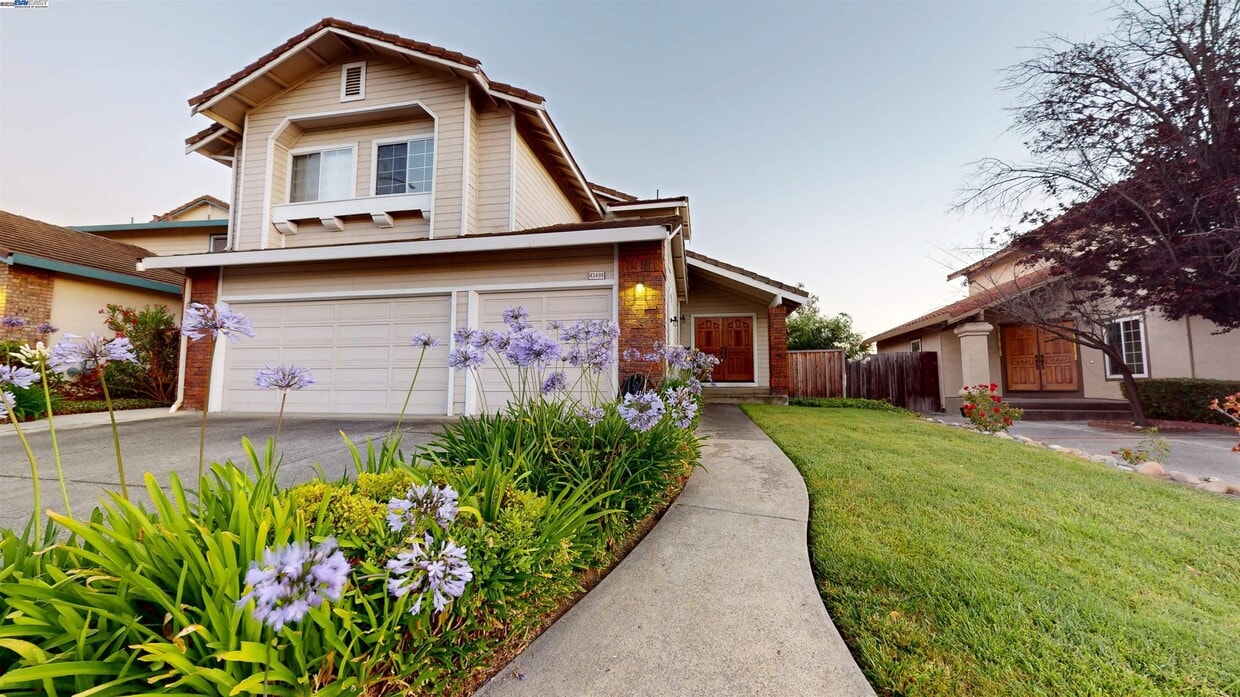
43499 Southerland Way
Fremont, CA 94539
Today
Favorites
510-676-2492
-
Bedrooms
3
-
Bathrooms
2.5
-
Square Feet
2,388 sq ft
-
Available
Available Aug 22
Highlights
- Contemporary Architecture
- 3 Car Attached Garage
- Tile Flooring
- Forced Air Heating and Cooling System
- Concrete Flooring
- Wood Burning Fireplace
43499 Southerland Way

Favorites
Matterport 3D Tour
About This Home
Available Aug 22
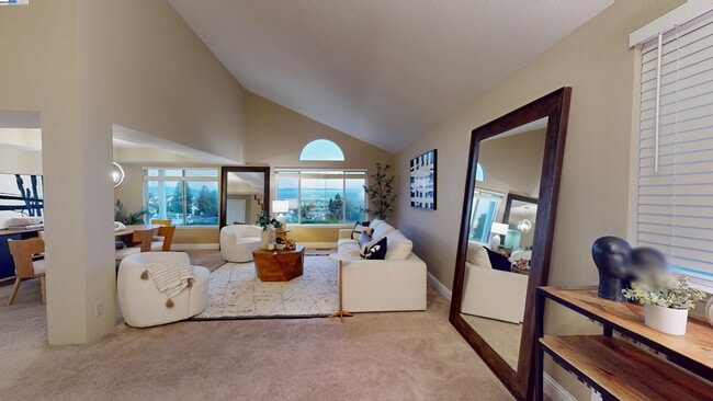
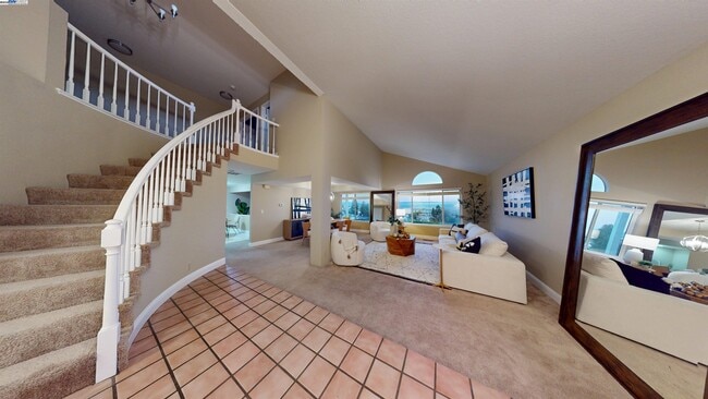
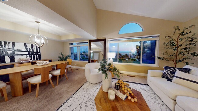
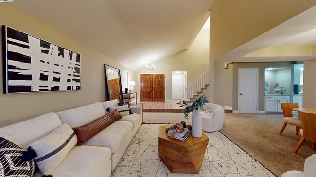
Stunning Home in Mission San Jose with Breathtaking Views & Top-Rated Schools! Discover this beautifully maintained residence in the heart of Mission San Jose,offering sweeping views and access to award-winning Mission schools. Featuring 4 bedrooms,2.5 bathrooms,and a spacious 3-car garage,this home perfectly balances elegance and comfort. The floor plan includes a grand formal living room and dining room—ideal for entertaining—along with a step-down family room featuring a cozy fireplace and adjoining casual dining area for everyday gatherings. Upstairs,the primary suite retreat boasts spectacular views,creating a serene space to unwind. Throughout the home,you’ll enjoy abundant natural light,a thoughtful layout,and timeless charm. Conveniently located just minutes from I-880,I-680,parks,and shopping,this home combines tranquility with easy access to everything you need. Experience Mission San Jose living at its finest—where comfort,community,and convenience come together.
43499 Southerland Way is a house located in Alameda County and the 94539 ZIP Code. This area is served by the Fremont Unified attendance zone.
* Price shown is base rent and may not include non-optional fees and utilities. Price, availability, fees, and any applicable rent special are subject to change without notice.
* Square footage definitions vary. Displayed square footage is approximate.
Home Details
Home Type
Single Family Detached Home
Year Built
Built in 1989
Bedrooms and Bathrooms
2.5 Bathrooms
3 Bedrooms
Flooring
Linoleum
Tile
Concrete
Carpet
Vinyl
Home Design
Contemporary Architecture
Tile Roof
Stucco
Interior Spaces
Family Room with Fireplace
Wood Burning Fireplace
Brick Fireplace
2-Story Property
Kitchen
Built-In Range
Microwave
Dishwasher
Laundry
Washer and Dryer Hookup
Listing and Financial Details
Assessor Parcel Number 51372522
Lot Details
6,259 Sq Ft Lot
Back and Front Yard
Parking
3 Car Attached Garage
Garage Door Opener
Utilities
Forced Air Heating and Cooling System
Gas Water Heater
Heating System Uses Natural Gas
Community Details
Overview
$72 Monthly HOA Fees
Inverness Ridge HOA
Inverness Ridge Subdivision
Association fees include street
Contact
- Listed by Homa Clifford | RE/MAX GOLD
- Phone Number
- Contact
-
Source
 Bay East Association of REALTORS ®
Copyright© 2025 Bay East, Contra Costa, bridgeMLS. All rights reserved. All information provided by the listing agent/broker is deemed reliable but is not guaranteed and should be independently verified.
Location
Get Directions
Fremont is a charming city in the San Francisco Bay Area that sits across the Bay from the Silicon Valley. It is known as an ideal destination for families, offering kid-friendly attractions and excellent public schools like the Children’s Natural History Museum and Washington High School. The rapid expansion of the tech industry in recent years has boosted Fremont’s reputation as a commuter-friendly city for those working in the Silicon Valley. Fremont is located directly north of San Jose, and Palo Alto is a short drive across the Dumbarton Bridge on the Bay.
Fremont’s local culture incorporates the area’s rich history and thriving arts scene. Check out the Old Town Niles region that features a popular art walk, antique fair, and a museum celebrating the town’s role in the early days of motion picture production. Exquisite historic architecture is on display around the city, so be sure to explore Fremont’s picturesque streets that blend urban amenities and suburban neighborhoods.
Learn more about living in Fremont
Education
| Colleges & Universities | Distance | ||
|---|---|---|---|
| Colleges & Universities | Distance | ||
| Drive: | 6 min | 1.6 mi | |
| Drive: | 13 min | 6.3 mi | |
| Drive: | 19 min | 11.5 mi | |
| Drive: | 28 min | 18.3 mi |
43499 Southerland Way is within 6 minutes or 1.6 miles from Ohlone College, Fremont Campus. It is also near Ohlone College, Newark and Palmer College of Chiropractic West Campus.
Schools


Public Elementary School
Grades K-5
478 Students
Attendance Zone
Public Elementary School
Grades K-5
343 Students
Nearby
Public Middle School
Grades 6-8
909 Students
Attendance Zone
Public High School
Grades 9-12
1,878 Students
Attendance Zone
Private Elementary, Middle & High School
Grades K-12
Nearby
Private Elementary School
Grades PK-6
231 Students
Nearby
Private High School
Grades 9-12
49 Students
Nearby
School data provided by
 The GreatSchools Rating helps parents compare schools within a state based on a variety of school quality indicators and provides a helpful picture of how effectively each school serves all of its students. Ratings are on a scale of 1 (below average) to 10 (above average) and can include test scores, college readiness, academic progress, advanced courses, equity, discipline and attendance data. We also advise parents to visit schools, consider other information on school performance and programs, and consider family needs as part of the school selection process.
View GreatSchools Rating Methodology
Data provided by GreatSchools.org © 2025. All rights reserved.
View GreatSchools Rating Methodology
Data provided by GreatSchools.org © 2025. All rights reserved.
Transportation options available in Fremont include Warm Springs / South Fremont, located 3.2 miles from 43499 Southerland Way. 43499 Southerland Way is near Norman Y Mineta San Jose International, located 15.5 miles or 23 minutes away, and Metro Oakland International, located 26.2 miles or 36 minutes away.
| Transit / Subway | Distance | ||
|---|---|---|---|
| Transit / Subway | Distance | ||
|
|
Drive: | 7 min | 3.2 mi |
|
|
Drive: | 12 min | 4.9 mi |
|
|
Drive: | 12 min | 5.0 mi |
|
|
Drive: | 20 min | 9.4 mi |
|
|
Drive: | 17 min | 10.3 mi |
| Commuter Rail | Distance | ||
|---|---|---|---|
| Commuter Rail | Distance | ||
| Drive: | 13 min | 6.0 mi | |
| Drive: | 14 min | 6.0 mi | |
| Drive: | 20 min | 13.1 mi | |
| Drive: | 19 min | 13.5 mi | |
| Drive: | 20 min | 13.6 mi |
| Airports | Distance | ||
|---|---|---|---|
| Airports | Distance | ||
|
Norman Y Mineta San Jose International
|
Drive: | 23 min | 15.5 mi |
|
Metro Oakland International
|
Drive: | 36 min | 26.2 mi |
Time and distance from 43499 Southerland Way.
| Shopping Centers | Distance | ||
|---|---|---|---|
| Shopping Centers | Distance | ||
| Drive: | 5 min | 1.6 mi | |
| Drive: | 6 min | 1.6 mi | |
| Drive: | 7 min | 3.0 mi |
43499 Southerland Way has 3 shopping centers within 3.0 miles, which is about a 7-minute drive. The miles and minutes will be for the farthest away property.
| Parks and Recreation | Distance | ||
|---|---|---|---|
| Parks and Recreation | Distance | ||
|
Central Park (Lake Elizabeth)
|
Drive: | 12 min | 4.9 mi |
|
Niles Canyon Railway
|
Drive: | 14 min | 6.5 mi |
|
Mission Peak Regional Preserve
|
Drive: | 22 min | 6.8 mi |
|
Niles Community Park
|
Drive: | 16 min | 7.0 mi |
|
Quarry Lakes Regional Recreation Area
|
Drive: | 16 min | 7.2 mi |
43499 Southerland Way has 5 parks within 7.2 miles, including Central Park (Lake Elizabeth), Mission Peak Regional Preserve, and Niles Canyon Railway.
| Hospitals | Distance | ||
|---|---|---|---|
| Hospitals | Distance | ||
| Drive: | 10 min | 4.3 mi | |
| Drive: | 12 min | 5.1 mi |
43499 Southerland Way is 4.3 miles from Kaiser Foundation Hospital - Fremont, and is convenient to other hospitals, including Washington Hospital.
| Military Bases | Distance | ||
|---|---|---|---|
| Military Bases | Distance | ||
| Drive: | 29 min | 18.3 mi |
43499 Southerland Way is 18.3 miles and a 29 minute drive from Ames Research Center.
You May Also Like
Similar Rentals Nearby


What Are Walk Score®, Transit Score®, and Bike Score® Ratings?
Walk Score® measures the walkability of any address. Transit Score® measures access to public transit. Bike Score® measures the bikeability of any address.
What is a Sound Score Rating?
A Sound Score Rating aggregates noise caused by vehicle traffic, airplane traffic and local sources
43499 Southerland Way
Fremont, CA 94539