

$4,000
/ Month
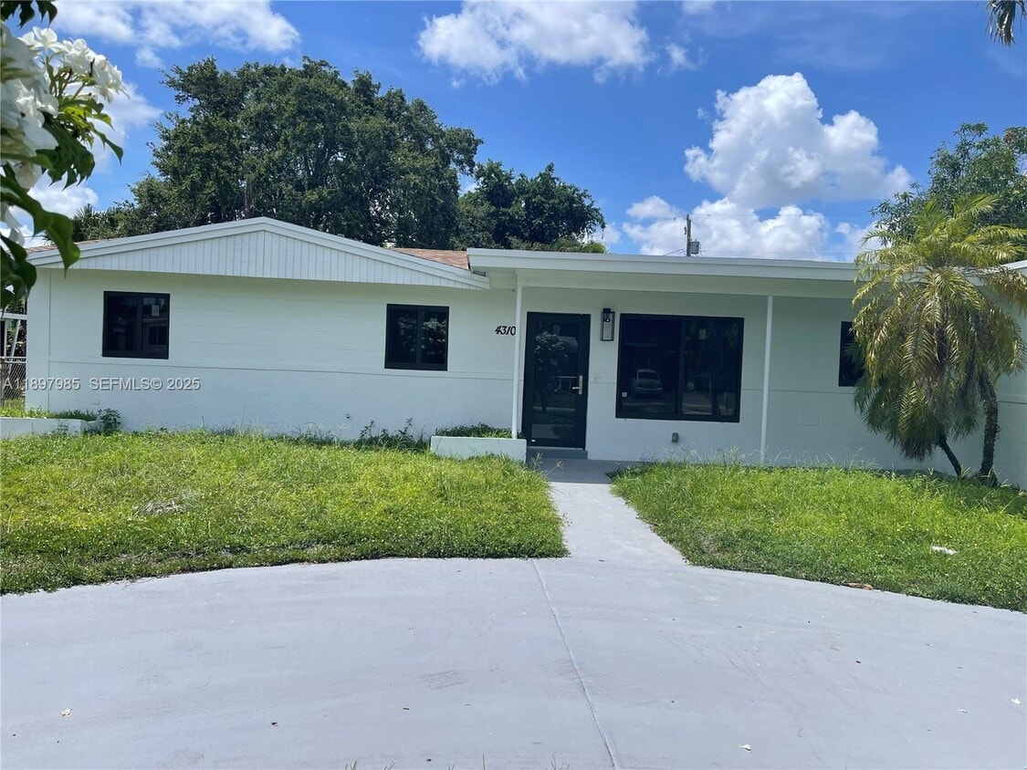
4310 NW 182nd St
Miami Gardens, FL 33055
Today
|
Edit
Favorites
305-877-8225
-
Bedrooms
4
-
Bathrooms
3
-
Square Feet
2,132 sq ft
-
Available
Available Now
4310 NW 182nd St

Favorites
About This Home
Available Now
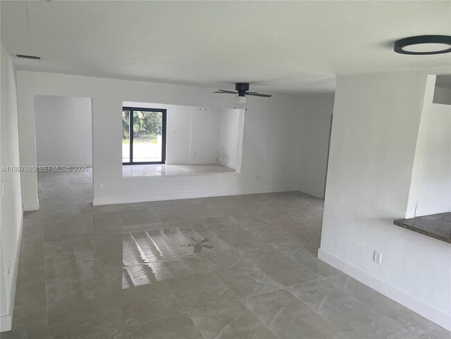
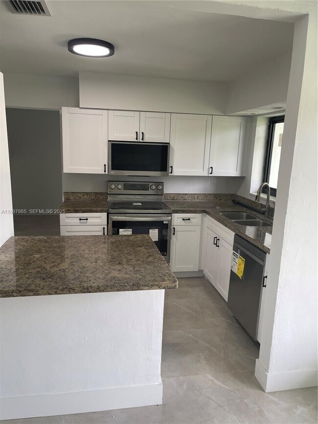
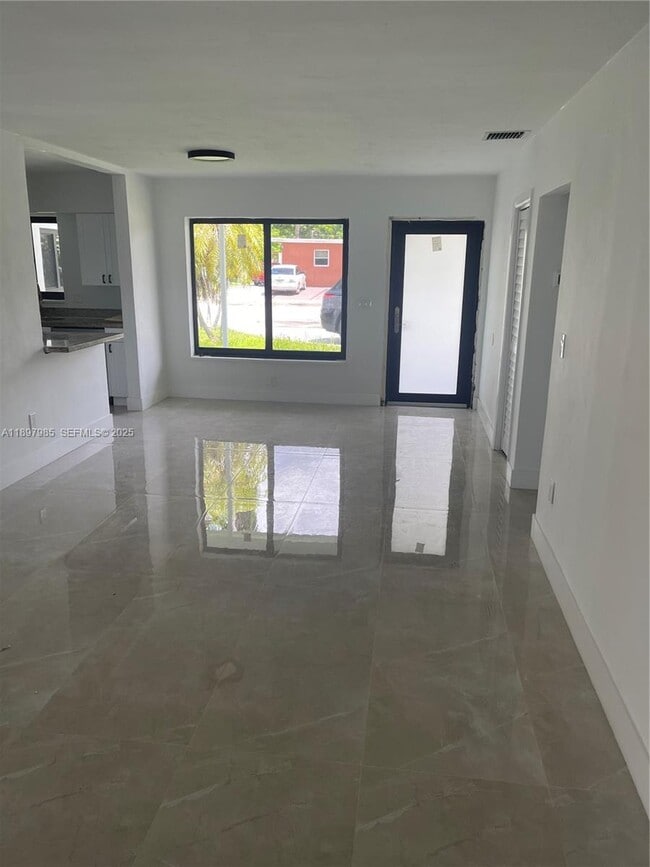
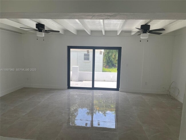
Welcome to this spacious and well-maintained home offering 4 bedrooms and 3 full bathrooms. The property has been very well taken care of and features a large backyard with an additional shed, perfect for extra storage. MLS # A11897985
4310 NW 182Nd St is a house located in Miami/Dade County and the 33055 ZIP Code. This area is served by the Miami-Dade County Public Schools attendance zone.
* Price shown is base rent. Excludes user-selected optional fees and variable or usage-based fees and required charges due at or prior to move-in or at move-out. Price, availability, fees, and any applicable rent special are subject to change without notice.
* Square footage definitions vary. Displayed square footage is approximate.
Home Details
Home Type
Single Family Detached Home
Year Built
Built in 1957
Bedrooms and Bathrooms
3 Full Bathrooms
4 Bedrooms
Interior Spaces
2,132 Sq Ft Home
Listing and Financial Details
Property Available on 10/17/25
Assessor Parcel Number 34-21-08-010-6130
Lot Details
9,525 Sq Ft Lot
Property is zoned 0100
Schools
Carol City Elementary And Middle School
Community Details
Overview
No Home Owners Association
Carol City 1 St Addn Condos
Carol City 1 St Addn Subdivision
Pet Policy
No Pets Allowed
Fees and Policies
The fees below are based on community-supplied data and may exclude additional fees and utilities.
-
One-Time Basics
-
Due at Application
-
Application Fee Per ApplicantCharged per applicant.$150
-
-
Due at Application
Property Fee Disclaimer: Based on community-supplied data and independent market research. Subject to change without notice. May exclude fees for mandatory or optional services and usage-based utilities.
Contact
- Listed by Mamoud Abouelazm | Opulent Real Estate, Inc
- Phone Number
- Contact
-
Source
 MIAMI Association of REALTORS®
Copyright © 2026 MIAMI Association of REALTORS®. All rights reserved. All information provided by the listing agent/broker is deemed reliable but is not guaranteed and should be independently verified.
Location
Get Directions
Miami Gardens is a vibrant, diverse suburb located midway between Miami and Fort Lauderdale in north central Miami-Dade County, bordering Broward County. Miami Gardens is home to the Hard Rock Stadium, where the Miami Dolphins and the University of Miami Hurricanes play. Calder Race Track is also situated in Miami Gardens.
Miami Gardens contains commercial shopping districts for the furniture and automobile trades along the Palmetto Expressway and U.S. 441, respectively. Saint Thomas University and Florida Memorial University both call Miami Gardens home too. Convenience to I-95, the Palmetto Expressway, and Florida’s Turnpike as well as the Florida East Coast Railway and the South Florida Tri-Rail System makes commuting and traveling from Miami Gardens simple.
Learn more about living in Miami Gardens
Education
| Colleges & Universities | Distance | ||
|---|---|---|---|
| Colleges & Universities | Distance | ||
| Drive: | 5 min | 1.9 mi | |
| Drive: | 5 min | 2.3 mi | |
| Drive: | 12 min | 6.0 mi | |
| Drive: | 15 min | 7.6 mi |
4310 NW 182nd St is within 5 minutes or 1.9 miles from Florida Memorial University. It is also near Saint Thomas University and Miami Dade College, North.
Schools


Public Elementary School
Grades PK-5
276 Students
Attendance Zone
Public Middle School
Grades 6-8
453 Students
Attendance Zone
Public High School
Grades 9-12
804 Students
Attendance Zone
Private Elementary School
Grades PK-6
Nearby
Private Elementary, Middle & High School
Grades 2-12
22 Students
Nearby
Private Elementary & Middle School
Grades K-8
Nearby
School data provided by
 The GreatSchools Rating helps parents compare schools within a state based on a variety of school quality indicators and provides a helpful picture of how effectively each school serves all of its students. Ratings are on a scale of 1 (below average) to 10 (above average) and can include test scores, college readiness, academic progress, advanced courses, equity, discipline and attendance data. We also advise parents to visit schools, consider other information on school performance and programs, and consider family needs as part of the school selection process.
View GreatSchools Rating Methodology
Data provided by GreatSchools.org © 2026. All rights reserved.
View GreatSchools Rating Methodology
Data provided by GreatSchools.org © 2026. All rights reserved.
Transportation options available in Miami Gardens include Miami Intl Airport Ground Level, located 11.8 miles from 4310 NW 182nd St. 4310 NW 182nd St is near Miami International, located 15.3 miles or 27 minutes away, and Fort Lauderdale/Hollywood International, located 16.1 miles or 26 minutes away.
| Transit / Subway | Distance | ||
|---|---|---|---|
| Transit / Subway | Distance | ||
|
Miami Intl Airport Ground Level
|
Drive: | 24 min | 11.8 mi |
|
Airport Station
|
Drive: | 26 min | 11.9 mi |
| Commuter Rail | Distance | ||
|---|---|---|---|
| Commuter Rail | Distance | ||
|
|
Drive: | 8 min | 4.1 mi |
|
|
Drive: | 11 min | 6.6 mi |
|
|
Drive: | 14 min | 7.9 mi |
|
|
Drive: | 15 min | 8.1 mi |
|
|
Drive: | 16 min | 8.3 mi |
| Airports | Distance | ||
|---|---|---|---|
| Airports | Distance | ||
|
Miami International
|
Drive: | 27 min | 15.3 mi |
|
Fort Lauderdale/Hollywood International
|
Drive: | 26 min | 16.1 mi |
Time and distance from 4310 NW 182nd St.
| Shopping Centers | Distance | ||
|---|---|---|---|
| Shopping Centers | Distance | ||
| Walk: | 7 min | 0.4 mi | |
| Walk: | 11 min | 0.6 mi | |
| Walk: | 12 min | 0.6 mi |
4310 NW 182nd St has 3 shopping centers within 0.6 mile, which is about a 12-minute walk. The miles and minutes will be for the farthest away property.
| Parks and Recreation | Distance | ||
|---|---|---|---|
| Parks and Recreation | Distance | ||
|
Miramar Pineland
|
Drive: | 9 min | 4.7 mi |
|
Greynolds Park
|
Drive: | 19 min | 8.6 mi |
|
Enchanted Forest Elaine Gordon Park
|
Drive: | 18 min | 9.7 mi |
|
Arch Creek Park & Nature Center
|
Drive: | 18 min | 9.8 mi |
|
Oleta River State Park
|
Drive: | 23 min | 10.6 mi |
4310 NW 182nd St has 5 parks within 10.6 miles, including Miramar Pineland, Greynolds Park, and Enchanted Forest Elaine Gordon Park.
| Hospitals | Distance | ||
|---|---|---|---|
| Hospitals | Distance | ||
| Drive: | 11 min | 6.0 mi | |
| Drive: | 12 min | 7.3 mi | |
| Drive: | 15 min | 7.5 mi |
4310 NW 182nd St has 3 hospitals within 7.5 miles, the nearest is South Florida State Hospital which is 6.0 miles away and a 11 minute drive.
You May Also Like
Similar Rentals Nearby


What Are Walk Score®, Transit Score®, and Bike Score® Ratings?
Walk Score® measures the walkability of any address. Transit Score® measures access to public transit. Bike Score® measures the bikeability of any address.
What is a Sound Score Rating?
A Sound Score Rating aggregates noise caused by vehicle traffic, airplane traffic and local sources
4310 NW 182nd St
Miami Gardens, FL 33055