
$4,200
Total Monthly Price
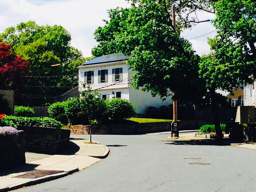
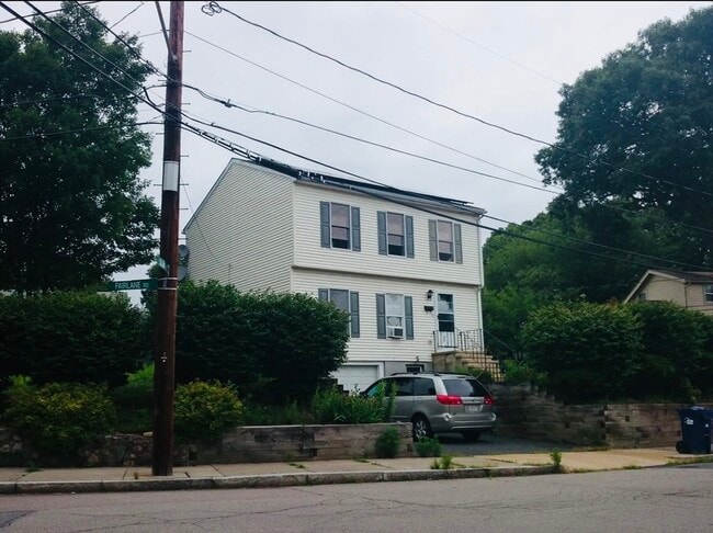
43 Fairlane Rd
Boston, MA 02132
1 Day Ago
Favorites
617-832-5721
-
Bedrooms
3
-
Bathrooms
1.5
-
Square Feet
1,485 sq ft
-
Available
Available Now
Highlights
- Medical Services
- Property is near public transit
- Community Pool
- Porch
- No Cooling
- Park
43 Fairlane Rd

Favorites
About This Home
$4,200 deposit,
Available Now
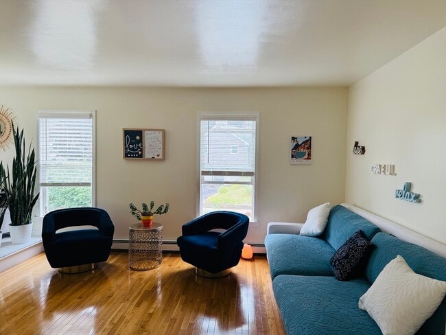
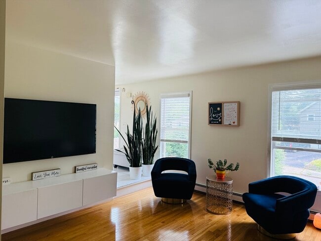
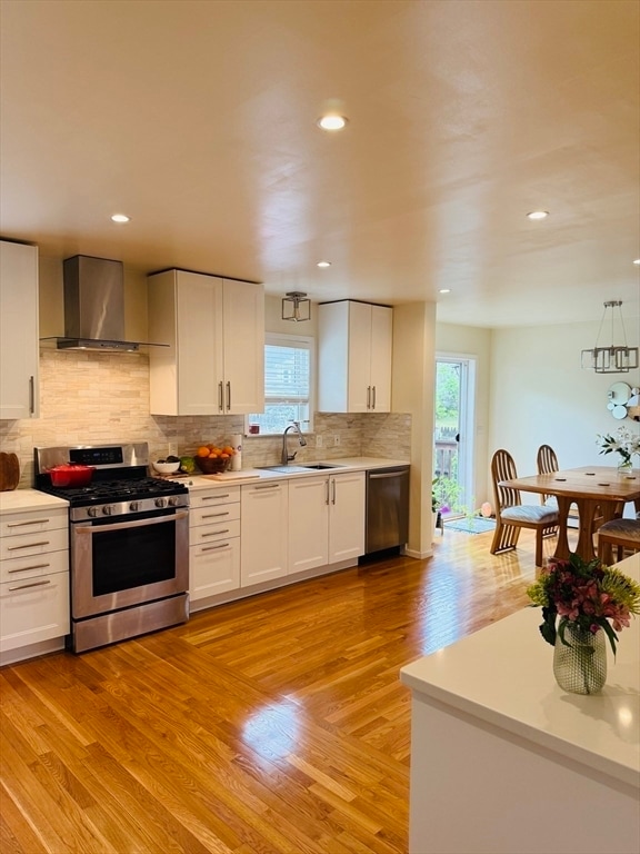
Welcome to a charming 3-bedroom,1.5-bath Colonial-style home offering a spacious and open layout perfect for modern living. The main level features hardwood floors throughout,with a seamless flow between the living room,dining area,and updated kitchen. Washer and dryer in the unit. Beautiful backyard—ideal for entertaining or relaxing Quiet residential neighborhood close to parks,schools,and shopping. The tenant is responsible for all the utilities. Available August 1 MLS# 73407123
43 Fairlane Rd is a house located in Suffolk County and the 02132 ZIP Code. This area is served by the Boston Public Schools attendance zone.
* Price shown is total price including community-supplied monthly required fees. Price, availability, fees, and any applicable rent special are subject to change without notice.
* Square footage definitions vary. Displayed square footage is approximate.
Home Details
Home Type
Single Family Detached Home
Year Built
Built in 1996
Accessible Home Design
Entry on the 2nd floor
Bedrooms and Bathrooms
1.5 Bathrooms
3 Bedrooms
Interior Spaces
1,485 Sq Ft Home
Kitchen
Range
Dishwasher
Disposal
Laundry
Dryer
Washer
Listing and Financial Details
Security Deposit $4,200
Property Available on 8/1/25
Assessor Parcel Number 1427942
Rent includes occupancy only
Location
Property is near public transit
Property is near schools
Lot Details
9,999 Sq Ft Lot
Outdoor Features
Porch
Parking
1 Car Garage
Utilities
No Cooling
Heating System Uses Natural Gas
Community Details
Amenities
Medical Services
Shops
Coin Laundry
Overview
No Home Owners Association
Pet Policy
No Pets Allowed
Recreation
Community Pool
Park
Bike Trail
Fees and Policies
The fees below are based on community-supplied data and may exclude additional fees and utilities.
Contact
- Listed by Entela Tase | Coldwell Banker Realty - Westwood
- Phone Number
-
Source
 MLS Property Information Network
The property listing data and information set forth herein were provided to MLS Property Information Network, Inc. from third party sources, including sellers, lessors and public records, and were compiled by MLS Property Information Network, Inc. The property listing data and information are for the personal, non-commercial use of consumers having a good faith interest in purchasing or leasing listed properties of the type displayed to them and may not be used for any purpose other than to identify prospective properties which such consumers may have a good faith interest in purchasing or leasing. MLS Property Information Network, Inc. and its subscribers disclaim any and all representations and warranties as to the accuracy of the property listing data and information set forth herein. All properties are subject to prior sale, change or withdrawal. Copyright © 2025 MLS Property Information Network, Inc. All rights reserved.
Location
Get Directions
Amenities
- Dishwasher
- Disposal
- Range
- Refrigerator
- Porch
Upper Washington-Spring Street is a neighborhood southwest of Boston in West Roxbury. Residents will find that Upper Washington-Spring Street is home to many cozy residential areas and great amenities. The neighborhood’s northern border sits along the Charles River and surrounding parks like Millennium Park, giving residents easy access to outdoor recreation. The hospital that serves this area, West Roxbury VAMC, sits along the river as well. Within Upper Washington-Spring Street, residents will find that picturesque parks like Ohrenberger Woodland Park dot the area. To the east of town, residents can travel along VFW Parkway to get to eateries and retail stores.
This neighborhood is a great town for commuters as the MBTA has both bus stops and rail lines accessible to the area. Apartments and condos scattered throughout town make up the majority of Upper Washington-Spring Street’s diverse rental options.
Learn more about living in Upper Washington-Spring St
Education
| Colleges & Universities | Distance | ||
|---|---|---|---|
| Colleges & Universities | Distance | ||
| Drive: | 12 min | 4.6 mi | |
| Drive: | 15 min | 6.8 mi | |
| Drive: | 16 min | 7.1 mi | |
| Drive: | 15 min | 7.4 mi |
43 Fairlane Rd is within 12 minutes or 4.6 miles from Curry College. It is also near Boston College and Boston College, Brighton.
Schools


Public Elementary & Middle School
Grades PK-8
396 Students
Attendance Zone
Public Elementary School
Grades PK-1
187 Students
Attendance Zone
Public Middle & High School
Grades 6-12
871 Students
Attendance Zone
Public Middle School
Grades 6-8
133 Students
Attendance Zone
Public High School
Grades 12
408 Students
Attendance Zone
Public High School
Grades 12
39 Students
Attendance Zone
Private Elementary School
Grades PK-6
330 Students
Nearby
Private Middle & High School
Grades 7-12
629 Students
Nearby
School data provided by
 The GreatSchools Rating helps parents compare schools within a state based on a variety of school quality indicators and provides a helpful picture of how effectively each school serves all of its students. Ratings are on a scale of 1 (below average) to 10 (above average) and can include test scores, college readiness, academic progress, advanced courses, equity, discipline and attendance data. We also advise parents to visit schools, consider other information on school performance and programs, and consider family needs as part of the school selection process.
View GreatSchools Rating Methodology
Data provided by GreatSchools.org © 2025. All rights reserved.
View GreatSchools Rating Methodology
Data provided by GreatSchools.org © 2025. All rights reserved.
Transportation options available in Boston include Forest Hills Station, located 4.3 miles from 43 Fairlane Rd. 43 Fairlane Rd is near General Edward Lawrence Logan International, located 12.6 miles or 27 minutes away.
| Transit / Subway | Distance | ||
|---|---|---|---|
| Transit / Subway | Distance | ||
|
|
Drive: | 10 min | 4.3 mi |
|
|
Drive: | 11 min | 4.6 mi |
|
|
Drive: | 13 min | 5.3 mi |
|
|
Drive: | 13 min | 5.5 mi |
|
|
Drive: | 14 min | 6.1 mi |
| Commuter Rail | Distance | ||
|---|---|---|---|
| Commuter Rail | Distance | ||
|
|
Drive: | 4 min | 1.4 mi |
|
|
Drive: | 5 min | 1.7 mi |
|
|
Drive: | 6 min | 2.2 mi |
|
|
Drive: | 8 min | 3.4 mi |
|
|
Drive: | 10 min | 4.3 mi |
| Airports | Distance | ||
|---|---|---|---|
| Airports | Distance | ||
|
General Edward Lawrence Logan International
|
Drive: | 27 min | 12.6 mi |
Time and distance from 43 Fairlane Rd.
| Shopping Centers | Distance | ||
|---|---|---|---|
| Shopping Centers | Distance | ||
| Walk: | 16 min | 0.8 mi | |
| Walk: | 19 min | 1.0 mi | |
| Walk: | 24 min | 1.3 mi |
43 Fairlane Rd has 3 shopping centers within 1.3 miles, which is about a 24-minute walk. The miles and minutes will be for the farthest away property.
| Parks and Recreation | Distance | ||
|---|---|---|---|
| Parks and Recreation | Distance | ||
|
Brook Farm Historic Site
|
Drive: | 3 min | 1.3 mi |
|
Stony Brook Reservation
|
Drive: | 6 min | 2.7 mi |
|
Cutler Park Reservation
|
Drive: | 9 min | 4.0 mi |
|
Arnold Arboretum of Harvard University
|
Drive: | 8 min | 4.1 mi |
|
Mass Audubon's Boston Nature Center and Wildlife Sanctuary
|
Drive: | 13 min | 5.0 mi |
43 Fairlane Rd has 5 parks within 5.0 miles, including Brook Farm Historic Site, Stony Brook Reservation, and Arnold Arboretum of Harvard University.
| Hospitals | Distance | ||
|---|---|---|---|
| Hospitals | Distance | ||
| Drive: | 7 min | 3.0 mi | |
| Drive: | 9 min | 4.4 mi | |
| Drive: | 11 min | 4.8 mi |
43 Fairlane Rd has 3 hospitals within 4.8 miles, the nearest is Bournewood Hospital which is 3.0 miles away and a 7 minute drive.
| Military Bases | Distance | ||
|---|---|---|---|
| Military Bases | Distance | ||
| Drive: | 24 min | 11.7 mi |
43 Fairlane Rd is 11.7 miles and a 24 minute drive from US Military Reservation.
You May Also Like
Similar Rentals Nearby
-
-

-

-

-

-

-

-
 $4,000Total Monthly Price12 Month Lease3 Beds, 1.5 Baths, 1,900 sq ftHouse for Rent
 -
 $6,500Total Monthly Price12 Month Lease5 Beds, 3.5 Baths, 2,498 sq ftHouse for Rent
 -
 $9,500Total Monthly Price12 Month Lease5 Beds, 3 Baths, 2,800 sq ftHouse for Rent
What Are Walk Score®, Transit Score®, and Bike Score® Ratings?
Walk Score® measures the walkability of any address. Transit Score® measures access to public transit. Bike Score® measures the bikeability of any address.
What is a Sound Score Rating?
A Sound Score Rating aggregates noise caused by vehicle traffic, airplane traffic and local sources

43 Fairlane Rd
Boston, MA 02132