
43 Burnham St
43 Burnham St,
Belmont,
MA
02478
2 Weeks Ago
Favorites
43 Burnham St

Favorites
Check Back Soon for Upcoming Availability
Fees and Policies
The fees below are based on community-supplied data and may exclude additional fees and utilities.
- Parking
-
Surface Lot--
Details
Lease Options
-
12 Months
Property Information
-
2 units
About 43 Burnham St Belmont, MA 02478
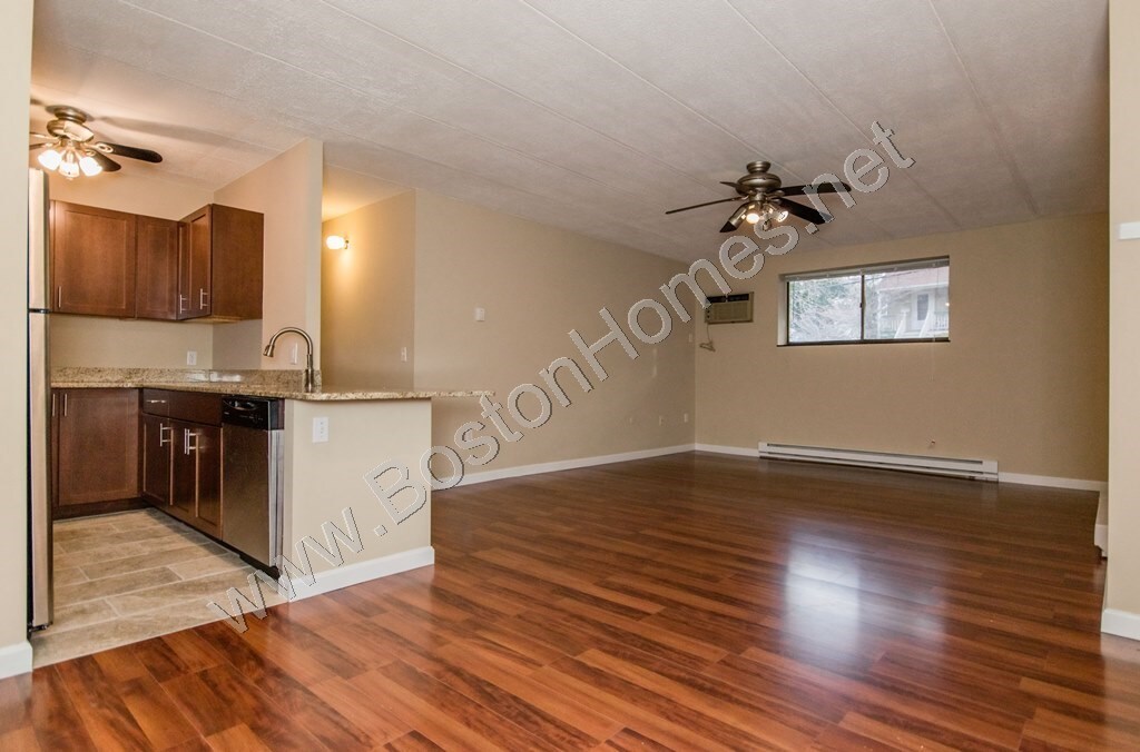
24 © craigslist - Map data © OpenStreetMap 43 Burnham (google map) 2BR / 1.5Ba 1060ft2 available now condo laundry in bldg no smoking off-street parking Sep 1st - Amazing ground floor deleaded 2 bedrooms and 1.5 bathrooms in an amazing neighborhood in Belmont the unit has Granite countertop, Dishwasher & Disposal, new bath, walk in closet, parking and private storage included. Quiet Neighborhood, Perfect for Commuters, 10 minutes walk to Waverley square, Trains, bus to Harvard Square, Grocery store, high walk score and much more! Easy access to Route 2, 95, and Storrow Drive. Tenant pays electric. Hot water is included. NO PETS. Actual facts of this apartment : 1- well managed building with a shared laundry room 2- Unit is deleaded so no lead paint 3- One parking is included in the rent 3- For a second car might be available for additional cost however not available at this time 4- upfront moving cost : 1st - 1925 Last -1925 Security -1000 broker fee : 1925 5- unit is Sep 1st moving date and you will get it professionally cleaned after 12 pm on Sep 1st. 6 - No balcony 7 - We accept applications based on credit and job references
43 Burnham St is a condo located in Middlesex County and the 02478 ZIP Code. This area is served by the Waltham attendance zone.
Condo Features
Dishwasher
Walk-In Closets
Granite Countertops
Disposal
- Smoke Free
- Dishwasher
- Disposal
- Granite Countertops
- Instant Hot Water
- Walk-In Closets
- Laundry Facilities
Location
Get Directions
Situated on Cambridge’s western border, about eight miles from Downtown Boston, Belmont is a picturesque suburb boasting a close-knit, small-town feel. Primarily a residential community, Belmont is known to locals as “the Town of Homes” with beautiful houses lining the Pleasant Street Historic District. Local businesses and popular chains also populate Leonard Street’s commercial corridor in Belmont.
Belmont offers residents easy access to Downtown Boston via the T and major roadways in addition to scenic natural surroundings. Convenience to Beaver Brook North Reservation, Rock Meadow Conservation Area, Lone Tree Hill, Claypit Pond, and Robbins Farm Park allows Belmont residents the opportunity to connect with nature at any time while nearby Harvard Square and Downtown Boston present endless options for metropolitan endeavors as well.
Learn more about living in BelmontBelow are rent ranges for similar nearby apartments
Amenities
- Smoke Free
- Dishwasher
- Disposal
- Granite Countertops
- Instant Hot Water
- Walk-In Closets
- Laundry Facilities
Education
| Colleges & Universities | Distance | ||
|---|---|---|---|
| Colleges & Universities | Distance | ||
| Drive: | 5 min | 1.8 mi | |
| Drive: | 10 min | 4.8 mi | |
| Drive: | 12 min | 5.1 mi | |
| Drive: | 13 min | 5.7 mi |
43 Burnham St is within 5 minutes or 1.8 miles from Bentley University. It is also near Boston College, Brighton and Lesley University.
Schools


Public Elementary School
Grades K-5
355 Students
Nearby
Public Elementary School
Grades K-5
378 Students
Attendance Zone
Public Middle School
Grades 6-8
595 Students
Attendance Zone
Public High School
Grades 9-12
1,751 Students
Attendance Zone
Private Elementary & Middle School
Grades PK-8
292 Students
Nearby
Private Elementary, Middle & High School
Grades 5-12
27 Students
Nearby
Private Elementary School
Grades PK-1
Nearby
Private Elementary School
Grades K
Nearby
Private High School
Grades 9-12
28 Students
Nearby
School data provided by
 The GreatSchools Rating helps parents compare schools within a state based on a variety of school quality indicators and provides a helpful picture of how effectively each school serves all of its students. Ratings are on a scale of 1 (below average) to 10 (above average) and can include test scores, college readiness, academic progress, advanced courses, equity, discipline and attendance data. We also advise parents to visit schools, consider other information on school performance and programs, and consider family needs as part of the school selection process.
View GreatSchools Rating Methodology
Data provided by GreatSchools.org © 2025. All rights reserved.
View GreatSchools Rating Methodology
Data provided by GreatSchools.org © 2025. All rights reserved.
Transportation options available in Belmont include Alewife Station, located 3.8 miles from 43 Burnham St. 43 Burnham St is near General Edward Lawrence Logan International, located 12.4 miles or 22 minutes away.
| Transit / Subway | Distance | ||
|---|---|---|---|
| Transit / Subway | Distance | ||
|
|
Drive: | 8 min | 3.8 mi |
| Drive: | 7 min | 3.8 mi | |
|
|
Drive: | 11 min | 5.1 mi |
|
|
Drive: | 12 min | 5.3 mi |
|
|
Drive: | 12 min | 5.5 mi |
| Commuter Rail | Distance | ||
|---|---|---|---|
| Commuter Rail | Distance | ||
|
|
Walk: | 9 min | 0.5 mi |
|
|
Drive: | 3 min | 1.5 mi |
|
|
Drive: | 6 min | 2.8 mi |
| Drive: | 6 min | 2.9 mi | |
|
|
Drive: | 7 min | 3.7 mi |
| Airports | Distance | ||
|---|---|---|---|
| Airports | Distance | ||
|
General Edward Lawrence Logan International
|
Drive: | 22 min | 12.4 mi |
Time and distance from 43 Burnham St.
| Shopping Centers | Distance | ||
|---|---|---|---|
| Shopping Centers | Distance | ||
| Drive: | 2 min | 1.2 mi | |
| Drive: | 4 min | 1.8 mi | |
| Drive: | 4 min | 2.0 mi |
43 Burnham St has 3 shopping centers within 2.0 miles, which is about a 4-minute drive. The miles and minutes will be for the farthest away property.
| Parks and Recreation | Distance | ||
|---|---|---|---|
| Parks and Recreation | Distance | ||
|
Beaver Brook Reservation
|
Walk: | 12 min | 0.7 mi |
|
Mass Audubon's Habitat Education Center and Wildlife Sanctuary
|
Drive: | 7 min | 2.6 mi |
|
Longfellow National Historic Site
|
Drive: | 8 min | 3.7 mi |
|
Harvard-Smithsonian Center for Astrophysics
|
Drive: | 9 min | 3.9 mi |
|
Harvard Museum of Natural History
|
Drive: | 11 min | 4.8 mi |
43 Burnham St has 5 parks within 4.8 miles, including Beaver Brook Reservation, Mass Audubon's Habitat Education Center and Wildlife Sanctuary, and Longfellow National Historic Site.
| Hospitals | Distance | ||
|---|---|---|---|
| Hospitals | Distance | ||
| Walk: | 18 min | 1.0 mi | |
| Drive: | 7 min | 3.3 mi | |
| Drive: | 7 min | 3.7 mi |
43 Burnham St has 3 hospitals within 3.7 miles, the nearest is McLean Hospital Corporation which is 1.0 mile away and a 18 minute walk.
| Military Bases | Distance | ||
|---|---|---|---|
| Military Bases | Distance | ||
| Drive: | 18 min | 8.2 mi | |
| Drive: | 25 min | 14.0 mi |
43 Burnham St is 8.2 miles from Hanscom Air Force Base, and is convenient to other military bases, including US Military Reservation.
You May Also Like
Similar Rentals Nearby
-
-
1 / 17

-
-
1 / 21

-
1 / 17

-
1 / 19

-
1 / 21

-
1 / 21

-
1 / 16

-
1 / 16


What Are Walk Score®, Transit Score®, and Bike Score® Ratings?
Walk Score® measures the walkability of any address. Transit Score® measures access to public transit. Bike Score® measures the bikeability of any address.
What is a Sound Score Rating?
A Sound Score Rating aggregates noise caused by vehicle traffic, airplane traffic and local sources