
-
4 br, 2 bath - 42 Ashford
-
-
$4,700
Total Monthly Price
42 Ashford St
ALLSTON, MA 02134
2 Weeks Ago
|
Edit
Favorites
42 Ashford St

Favorites
Check Back Soon for Upcoming Availability
| Beds | Baths | Average SF |
|---|---|---|
| 4 Bedrooms 4 Bedrooms 4 Br | 2 Baths 2 Baths 2 Ba | — |
About This Property
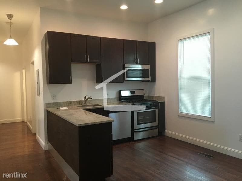
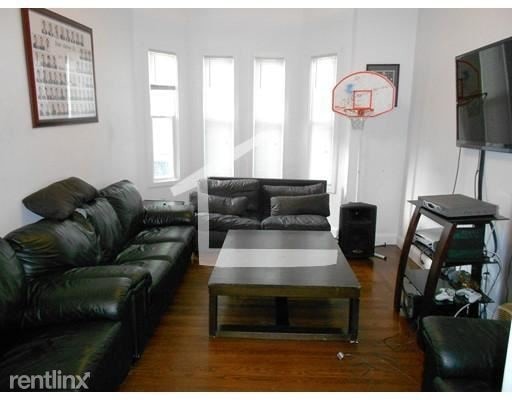
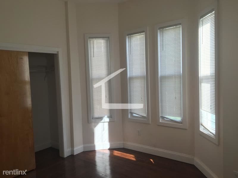
(207) 680-0039 - LOCATION! This spacious 4 bedroom apartment is a great deal! This cozy apartment is located in the heart of Allston. Just minutes away from the Commonwealth ave, and the Green line T. This unique apartment features beautiful hardwood flooring. A large living room with a beautiful fireplace. (RLNE3899898) Lease lengths - 12 Months.
42 Ashford St is a condo located in Suffolk County and the 02134 ZIP Code. This area is served by the Match Charter Public School (District) attendance zone.
Location
Get Directions
Best known for its rising student population and proximity to Harvard Business School, Allston’s diverse community and focus on academics makes it a great neighborhood to live in. While the area is very student-dense, its youthful atmosphere and short commute to Downtown Boston make it a hot spot for trendy restaurants, coffee shops, and things to do. The city offers tons of bars, multicultural restaurants, and cool music venues. On Brighton Avenue, you’ll discover Brighton Music Hall, which is down the road from the Paradise Rock Club.
When you rent an apartment in Allston, you’ll have access to many MBTA rail stations to get you from point A to point B. Students enjoy a bike ride after class at Christian Herter Park, which has breathtaking views of the Charles River. Affordability makes this community an attractive option for many locals. How much does it cost to live in Allston? Average apartment rent sits around $2,538/month, well below the city average.
Learn more about living in Allston
Education
| Colleges & Universities | Distance | ||
|---|---|---|---|
| Colleges & Universities | Distance | ||
| Drive: | 3 min | 1.1 mi | |
| Drive: | 4 min | 1.8 mi | |
| Drive: | 5 min | 1.9 mi | |
| Drive: | 5 min | 2.2 mi |
42 Ashford St is within 3 minutes or 1.1 miles from Boston University. It is also near Lesley Univ., Art Institute and Harvard University.
Schools

Charter Elementary, Middle & High School
Grades PK-12
1,186 Students
Nearby
Private Elementary, Middle & High School
Grades PK-12
281 Students
Nearby
Private Elementary & Middle School
Grades K-8
30 Students
Nearby
Private Middle & High School
Grades 8-12
27 Students
Nearby
School data provided by
 The GreatSchools Rating helps parents compare schools within a state based on a variety of school quality indicators and provides a helpful picture of how effectively each school serves all of its students. Ratings are on a scale of 1 (below average) to 10 (above average) and can include test scores, college readiness, academic progress, advanced courses, equity, discipline and attendance data. We also advise parents to visit schools, consider other information on school performance and programs, and consider family needs as part of the school selection process.
View GreatSchools Rating Methodology
Data provided by GreatSchools.org © 2025. All rights reserved.
View GreatSchools Rating Methodology
Data provided by GreatSchools.org © 2025. All rights reserved.
Transportation options available in ALLSTON include Packard's Corner Station, located 0.3 mile from 42 Ashford St. 42 Ashford St is near General Edward Lawrence Logan International, located 8.1 miles or 14 minutes away.
| Transit / Subway | Distance | ||
|---|---|---|---|
| Transit / Subway | Distance | ||
|
|
Walk: | 6 min | 0.3 mi |
|
|
Walk: | 8 min | 0.5 mi |
|
|
Walk: | 9 min | 0.5 mi |
|
|
Walk: | 11 min | 0.6 mi |
|
|
Walk: | 12 min | 0.7 mi |
| Commuter Rail | Distance | ||
|---|---|---|---|
| Commuter Rail | Distance | ||
|
|
Drive: | 4 min | 2.3 mi |
|
|
Drive: | 7 min | 2.8 mi |
|
|
Drive: | 7 min | 3.2 mi |
|
|
Drive: | 10 min | 4.0 mi |
| Drive: | 11 min | 5.4 mi |
| Airports | Distance | ||
|---|---|---|---|
| Airports | Distance | ||
|
General Edward Lawrence Logan International
|
Drive: | 14 min | 8.1 mi |
Time and distance from 42 Ashford St.
| Shopping Centers | Distance | ||
|---|---|---|---|
| Shopping Centers | Distance | ||
| Walk: | 6 min | 0.3 mi | |
| Drive: | 3 min | 1.2 mi | |
| Drive: | 4 min | 1.5 mi |
42 Ashford St has 3 shopping centers within 1.5 miles, which is about a 4-minute walk. The miles and minutes will be for the farthest away property.
| Parks and Recreation | Distance | ||
|---|---|---|---|
| Parks and Recreation | Distance | ||
|
John Fitzgerald Kennedy National Historic Site
|
Drive: | 3 min | 1.2 mi |
|
Coit Observatory
|
Drive: | 4 min | 1.6 mi |
|
Charles River Reservation
|
Drive: | 7 min | 2.7 mi |
|
Longfellow National Historic Site
|
Drive: | 6 min | 2.7 mi |
|
Harvard Museum of Natural History
|
Drive: | 7 min | 2.9 mi |
42 Ashford St has 5 parks within 2.9 miles, including John Fitzgerald Kennedy National Historic Site, Coit Observatory, and Charles River Reservation.
| Hospitals | Distance | ||
|---|---|---|---|
| Hospitals | Distance | ||
| Walk: | 10 min | 0.6 mi | |
| Drive: | 3 min | 1.3 mi | |
| Drive: | 3 min | 1.3 mi |
42 Ashford St has 3 hospitals within 1.3 miles, the nearest is Arbour Human Resource Institute which is 0.6 mile away and a 10 minute walk.
| Military Bases | Distance | ||
|---|---|---|---|
| Military Bases | Distance | ||
| Drive: | 26 min | 13.9 mi | |
| Drive: | 26 min | 14.8 mi |
42 Ashford St is 13.9 miles from Hanscom Air Force Base, and is convenient to other military bases, including US Military Reservation.
You May Also Like
Similar Rentals Nearby


What Are Walk Score®, Transit Score®, and Bike Score® Ratings?
Walk Score® measures the walkability of any address. Transit Score® measures access to public transit. Bike Score® measures the bikeability of any address.
What is a Sound Score Rating?
A Sound Score Rating aggregates noise caused by vehicle traffic, airplane traffic and local sources

42 Ashford St
ALLSTON, MA 02134