
$3,600
/ Month
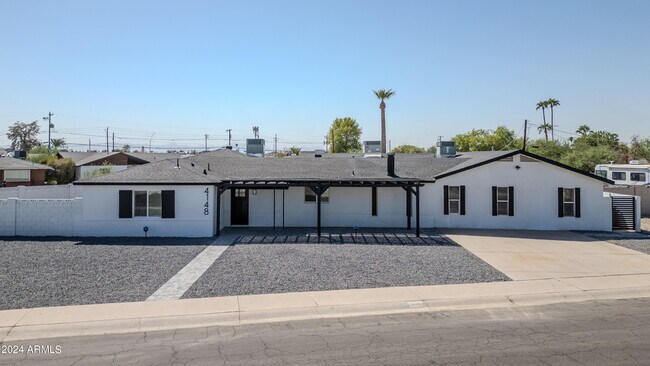
4148 N Westview Dr
Phoenix, AZ 85015
Today
|
Edit
Favorites
480-510-9628
-
Bedrooms
4
-
Bathrooms
3
-
Square Feet
4,097 sq ft
-
Available
Available Now
Highlights
- The property is located in a historic district
- RV Gated
- Granite Countertops
- Gazebo
- Eat-In Kitchen
- Double Vanity
4148 N Westview Dr

Favorites
About This Home
$3,700 deposit,
Available Now
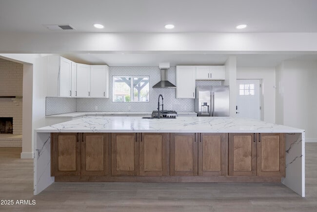
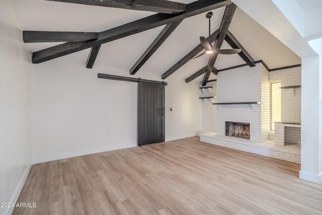
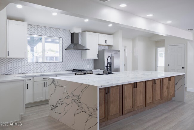
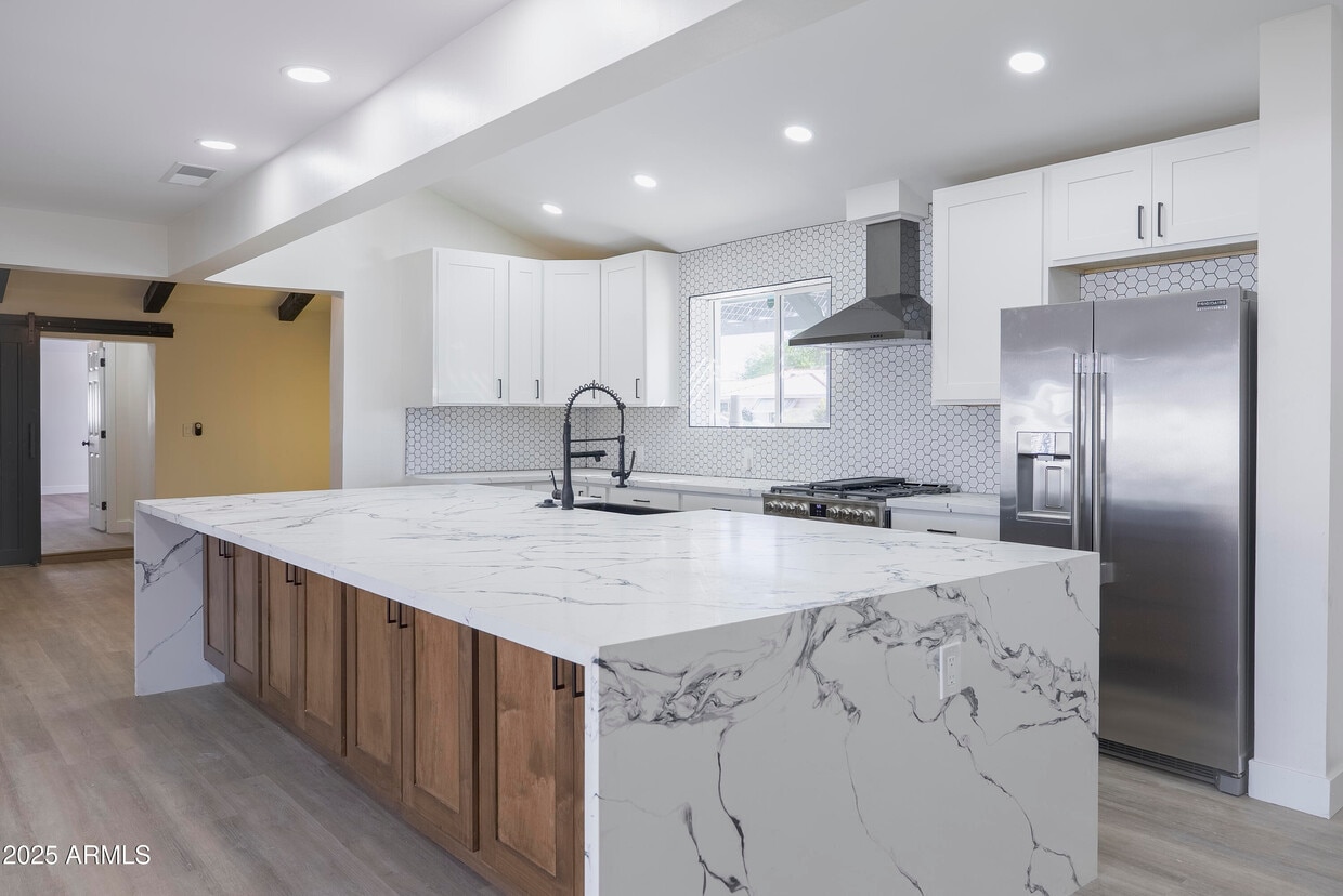
Remodeled home in Historic Bel Air neighborhood with 4 bed,3 bath,4,097 sq. ft. RV parking,with electric RV gate and 13k lot,Whole house has been updated. Updates include 2 master suites,quartz counters,new plumbing,new windows,electric RV gate,RV parking,new gates,new appliances,new flooring,new baseboards,new cabinets,new electrical,new Trane AC units,new roof,new paint,fire place,new insulation,new tile,new pavers,new pergola's,new fixtures,new toilets,new baseboards,new paint.
4148 N Westview Dr is a house located in Maricopa County and the 85015 ZIP Code. This area is served by the Osborn Elementary District attendance zone.
* Price shown is base rent. Excludes user-selected optional fees and variable or usage-based fees and required charges due at or prior to move-in or at move-out. Price, availability, fees, and any applicable rent special are subject to change without notice.
* Square footage definitions vary. Displayed square footage is approximate.
Home Details
Year Built
Built in 1949
Bedrooms and Bathrooms
Double Vanity
3 Bathrooms
4 Bedrooms
Bathtub With Separate Shower Stall
Home Design
Spray Foam Insulation
Block Exterior
Composition Roof
Stucco
Interior Spaces
Family Room with Fireplace
Ceiling Fan
Vinyl Flooring
4,097 Sq Ft Home
1-Story Property
Kitchen
Granite Countertops
Eat-In Kitchen
Breakfast Bar
Kitchen Island
Gas Cooktop
Built-In Microwave
Laundry
Dryer
Washer
Listing and Financial Details
Property Available on 10/22/25
$65 Move-In Fee
6-Month Minimum Lease Term
$65 Application Fee
Tax Lot 1
Assessor Parcel Number 155-48-102
Location
The property is located in a historic district
Lot Details
0.32 Acre Lot
Block Wall Fence
Outdoor Features
Gazebo
Parking
RV Gated
2 Carport Spaces
6 Open Parking Spaces
Schools
Encanto Elementary School
Clarendon Middle School
Metro Tech High School
Utilities
Central Air
High Speed Internet
Heating Available
Cable TV Available
Community Details
Overview
No Home Owners Association
Bel Air Subdivision
Pet Policy
Call for details about the types of pets allowed
Fees and Policies
The fees below are based on community-supplied data and may exclude additional fees and utilities.
-
One-Time Basics
-
Due at Application
-
Application Fee Per ApplicantCharged per applicant.$65
-
-
Due at Move-In
-
Security Deposit - RefundableCharged per unit.$3,700
-
-
Due at Application
Property Fee Disclaimer: Based on community-supplied data and independent market research. Subject to change without notice. May exclude fees for mandatory or optional services and usage-based utilities.
Contact
- Listed by Phillip Shaver | HomeSmart
- Phone Number
- Contact
-
Source
Arizona Regional MLS
Copyright 2025 Arizona Regional MLS. All rights reserved. Information is deemed reliable but not guaranteed.
Location
Get Directions
Midtown Phoenix offers a wide variety of rental communities within close proximity to major highways, the light rail, and Downtown Phoenix, making it an ideal neighborhood for commuters. Midtown Phoenix also touts exceptional dining options with a slew of cozy cafes, tasty restaurants, and modern eateries located along North Central Avenue and East Camelback Road.
Shopping opportunities abound near Midtown Phoenix as well, with retail destinations like Camelback Colonnade and Biltmore Fashion Park situated within close proximity. Midtown Phoenix is also nearby plenty of recreational activities at local parks as well as the sprawling Phoenix Mountains Preserve, which is just a short drive away.
Learn more about living in Midtown Phoenix
Education
| Colleges & Universities | Distance | ||
|---|---|---|---|
| Colleges & Universities | Distance | ||
| Drive: | 4 min | 1.2 mi | |
| Drive: | 10 min | 3.8 mi | |
| Drive: | 10 min | 4.5 mi | |
| Drive: | 10 min | 4.6 mi |
4148 N Westview Dr is within 4 minutes or 1.2 miles from Phoenix College. It is also near Grand Canyon University and Arizona State Univ., Downtown.
Schools


Public Elementary & Middle School
Grades PK-8
665 Students
Attendance Zone
Public Elementary & Middle School
Grades PK-8
420 Students
Attendance Zone
Public Middle School
Grades 7-8
504 Students
Attendance Zone
Public High School
Grades 9-12
1,901 Students
Attendance Zone
Private Elementary, Middle & High School
Grades PK-12
473 Students
Nearby
School data provided by
 The GreatSchools Rating helps parents compare schools within a state based on a variety of school quality indicators and provides a helpful picture of how effectively each school serves all of its students. Ratings are on a scale of 1 (below average) to 10 (above average) and can include test scores, college readiness, academic progress, advanced courses, equity, discipline and attendance data. We also advise parents to visit schools, consider other information on school performance and programs, and consider family needs as part of the school selection process.
View GreatSchools Rating Methodology
Data provided by GreatSchools.org © 2025. All rights reserved.
View GreatSchools Rating Methodology
Data provided by GreatSchools.org © 2025. All rights reserved.
Transportation options available in Phoenix include Indian School/Central Ave, located 1.4 miles from 4148 N Westview Dr. 4148 N Westview Dr is near Phoenix Sky Harbor International, located 9.7 miles or 18 minutes away, and Phoenix-Mesa Gateway, located 36.4 miles or 50 minutes away.
| Transit / Subway | Distance | ||
|---|---|---|---|
| Transit / Subway | Distance | ||
|
|
Drive: | 3 min | 1.4 mi |
|
|
Drive: | 4 min | 1.5 mi |
|
|
Drive: | 4 min | 1.7 mi |
|
|
Drive: | 4 min | 1.7 mi |
|
|
Drive: | 5 min | 2.2 mi |
| Commuter Rail | Distance | ||
|---|---|---|---|
| Commuter Rail | Distance | ||
|
|
Drive: | 50 min | 37.5 mi |
| Airports | Distance | ||
|---|---|---|---|
| Airports | Distance | ||
|
Phoenix Sky Harbor International
|
Drive: | 18 min | 9.7 mi |
|
Phoenix-Mesa Gateway
|
Drive: | 50 min | 36.4 mi |
Time and distance from 4148 N Westview Dr.
| Shopping Centers | Distance | ||
|---|---|---|---|
| Shopping Centers | Distance | ||
| Walk: | 9 min | 0.5 mi | |
| Walk: | 11 min | 0.6 mi | |
| Walk: | 12 min | 0.6 mi |
4148 N Westview Dr has 3 shopping centers within 0.6 mile, which is about a 12-minute walk. The miles and minutes will be for the farthest away property.
| Parks and Recreation | Distance | ||
|---|---|---|---|
| Parks and Recreation | Distance | ||
|
Steele Indian School Park
|
Drive: | 4 min | 1.5 mi |
|
Japanese Friendship Garden
|
Drive: | 8 min | 3.3 mi |
|
Civic Space Park
|
Drive: | 9 min | 4.4 mi |
|
Margaret T. Hance Park
|
Drive: | 10 min | 4.5 mi |
|
Desert Storm Park
|
Drive: | 11 min | 5.6 mi |
4148 N Westview Dr has 5 parks within 5.6 miles, including Steele Indian School Park, Margaret T. Hance Park, and Japanese Friendship Garden.
| Hospitals | Distance | ||
|---|---|---|---|
| Hospitals | Distance | ||
| Drive: | 4 min | 1.9 mi | |
| Drive: | 5 min | 2.5 mi | |
| Drive: | 6 min | 2.9 mi |
4148 N Westview Dr has 3 hospitals within 2.9 miles, the nearest is St. Joseph's Hospital and Medical Center which is 1.9 miles away and a 4 minute drive.
| Military Bases | Distance | ||
|---|---|---|---|
| Military Bases | Distance | ||
| Drive: | 18 min | 9.5 mi | |
| Drive: | 31 min | 17.5 mi | |
| Drive: | 100 min | 74.9 mi |
4148 N Westview Dr has 3 military bases within 74.9 miles, the nearest is Phoenix Sky Harbor Airport Air Guard Station which is 9.5 miles away and a 18 minute drive.
You May Also Like
Similar Rentals Nearby


What Are Walk Score®, Transit Score®, and Bike Score® Ratings?
Walk Score® measures the walkability of any address. Transit Score® measures access to public transit. Bike Score® measures the bikeability of any address.
What is a Sound Score Rating?
A Sound Score Rating aggregates noise caused by vehicle traffic, airplane traffic and local sources
4148 N Westview Dr
Phoenix, AZ 85015