
Presidential Towers
555 W Madison St,
Chicago, IL 60661
$1,659 - $6,667
Studio - 2 Beds
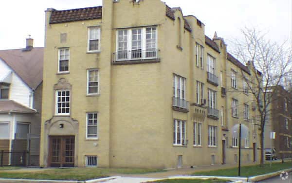

Discover your new home at 4115 N Wolcott Ave in Chicago, IL. The 4115 N. Wolcott Ave location in Chicago's 60613 area has so much to offer its residents. Here at this community, the professional leasing team will be ready to help you find your perfect apartment. Be sure to come for a visit to check out the apartment floorplan options. Drop by to talk about leasing your new apartment.
4115 N Wolcott Ave is an apartment community located in Cook County and the 60613 ZIP Code. This area is served by the Chicago Public Schools attendance zone.
Heating
Oven
Range
Kitchen
Situated in North Side Chicago, North Center is a small community about five miles from Downtown Chicago spanning to the west of the North Branch River. Most of the urban area is residential with a selection of apartments, condos, and single-family houses for rent at various price points. Everything from trendy lofts to cozy single-family homes is available in North Center’s rental market. The other parts of town are made up of shops, breweries, pizzerias, and an array of other dining options placed along Lincoln Avenue and Irving Park Road. For outdoor recreation in town, residents enjoy the two large community parks, Horner Park and Revere Park, equipped with playgrounds, sports fields, and walking paths.
Learn more about living in North CenterCompare neighborhood and city base rent averages by bedroom.
| North Center | Chicago, IL | |
|---|---|---|
| Studio | $1,452 | $1,651 |
| 1 Bedroom | $1,913 | $2,055 |
| 2 Bedrooms | $2,177 | $2,591 |
| 3 Bedrooms | $3,562 | $3,101 |
| Colleges & Universities | Distance | ||
|---|---|---|---|
| Colleges & Universities | Distance | ||
| Drive: | 4 min | 1.6 mi | |
| Drive: | 4 min | 2.0 mi | |
| Drive: | 6 min | 2.9 mi | |
| Drive: | 6 min | 3.2 mi |


Transportation options available in Chicago include Irving Park Station (Brown Line), located 0.2 mile from 4115 N Wolcott Ave. 4115 N Wolcott Ave is near Chicago O'Hare International, located 13.0 miles or 21 minutes away, and Chicago Midway International, located 16.2 miles or 26 minutes away.
| Transit / Subway | Distance | ||
|---|---|---|---|
| Transit / Subway | Distance | ||
|
|
Walk: | 4 min | 0.2 mi |
|
|
Walk: | 8 min | 0.4 mi |
|
|
Walk: | 14 min | 0.8 mi |
|
|
Walk: | 15 min | 0.8 mi |
|
|
Drive: | 3 min | 1.2 mi |
| Commuter Rail | Distance | ||
|---|---|---|---|
| Commuter Rail | Distance | ||
|
|
Drive: | 3 min | 1.2 mi |
| Drive: | 6 min | 2.8 mi | |
|
|
Drive: | 6 min | 3.0 mi |
|
|
Drive: | 5 min | 3.1 mi |
|
|
Drive: | 7 min | 4.1 mi |
| Airports | Distance | ||
|---|---|---|---|
| Airports | Distance | ||
|
Chicago O'Hare International
|
Drive: | 21 min | 13.0 mi |
|
Chicago Midway International
|
Drive: | 26 min | 16.2 mi |
Scores provided by
Traffic
-Airport
-Businesses
-Scores provided by
HowLoud What is a Sound Score Rating? A Sound Score Rating aggregates noise caused by vehicle traffic, airplane traffic and local sources. How It WorksTime and distance from 4115 N Wolcott Ave.
| Shopping Centers | Distance | ||
|---|---|---|---|
| Shopping Centers | Distance | ||
| Walk: | 9 min | 0.5 mi | |
| Drive: | 2 min | 1.3 mi |
| Parks and Recreation | Distance | ||
|---|---|---|---|
| Parks and Recreation | Distance | ||
|
Chase Park
|
Drive: | 3 min | 1.2 mi |
|
Winnemac Park
|
Drive: | 4 min | 1.6 mi |
|
Wrightwood Park
|
Drive: | 6 min | 2.5 mi |
|
Oz Park
|
Drive: | 8 min | 3.7 mi |
|
Notebaert Nature Museum
|
Drive: | 7 min | 3.8 mi |
| Hospitals | Distance | ||
|---|---|---|---|
| Hospitals | Distance | ||
| Drive: | 2 min | 1.5 mi | |
| Drive: | 4 min | 1.7 mi | |
| Drive: | 5 min | 2.3 mi |
| Military Bases | Distance | ||
|---|---|---|---|
| Military Bases | Distance | ||
| Drive: | 29 min | 20.7 mi | |
| Drive: | 42 min | 31.6 mi | |
| Drive: | 50 min | 32.8 mi |
What Are Walk Score®, Transit Score®, and Bike Score® Ratings?
Walk Score® measures the walkability of any address. Transit Score® measures access to public transit. Bike Score® measures the bikeability of any address.
What is a Sound Score Rating?
A Sound Score Rating aggregates noise caused by vehicle traffic, airplane traffic and local sources.

4115 N Wolcott Ave
Chicago, IL 60613


