
Venue Residences
3688 Overland Ave,
Los Angeles, CA 90034
$2,795 - $7,150
Studio - 2 Beds
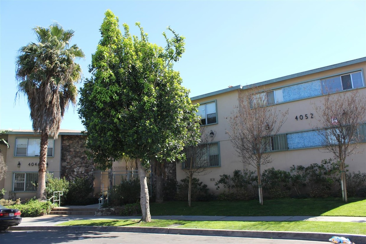
Welcome to 4066 Coco, situated in a prime location in Los Angeles, and a part of the Collection at Baldwin. Your apartment home comes newly renovated with stainless steel appliances, vinyl plank floors, and upgraded windows. You will also enjoy a controlled access building with laundry facilities and covered parking. We are conveniently located close to restaurants, schools, parks, and the 10 freeway. Call today to schedule a tour with our professional leasing staff.
4066 Coco is an apartment community located in Los Angeles County and the 90008 ZIP Code. This area is served by the Los Angeles Unified attendance zone.
Crenshaw is a diverse neighborhood located in South Los Angeles, California. Crenshaw, which is rooted in African American history, is home to the famous Hyde Park neighborhood that’s often referred to as “the heart of African American commerce in Los Angeles.” Famous rapper Nipsey Hussle paid tribute to Crenshaw Boulevard in his songs.
The neighborhood has great access to the LAX metro system with lines running to the Los Angeles International Airport.
Crenshaw provides quick access to I-105 and I-10, making it simple to access Downtown Los Angeles. The Kenneth Hahn State Recreation area, located nearby, features a workout course, Japanese gardens, athletic fields, disc golf, and walking/running trails. Every year, the neighborhood hosts “Destination Crenshaw,” a 1.3-mile-long outdoor art and culture exhibit featuring Black Los Angeles. When you rent your apartment in Crenshaw, you‘ll enjoy a neighborhood rich with African American history where culture is celebrated.
Learn more about living in Crenshaw| Colleges & Universities | Distance | ||
|---|---|---|---|
| Colleges & Universities | Distance | ||
| Drive: | 10 min | 4.1 mi | |
| Drive: | 10 min | 5.3 mi | |
| Drive: | 11 min | 5.9 mi | |
| Drive: | 12 min | 6.1 mi |


Transportation options available in Los Angeles include Farmdale, located 1.0 miles from 4066 Coco. 4066 Coco is near Los Angeles International, located 7.9 miles or 16 minutes away, and Bob Hope, located 16.9 miles or 31 minutes away.
| Transit / Subway | Distance | ||
|---|---|---|---|
| Transit / Subway | Distance | ||
|
|
Walk: | 20 min | 1.0 mi |
|
|
Drive: | 4 min | 1.3 mi |
| Drive: | 4 min | 1.5 mi | |
|
|
Drive: | 4 min | 1.5 mi |
| Drive: | 4 min | 1.8 mi |
| Commuter Rail | Distance | ||
|---|---|---|---|
| Commuter Rail | Distance | ||
|
|
Drive: | 16 min | 9.0 mi |
|
|
Drive: | 18 min | 9.2 mi |
|
|
Drive: | 22 min | 12.0 mi |
| Drive: | 20 min | 13.1 mi | |
|
|
Drive: | 28 min | 15.7 mi |
| Airports | Distance | ||
|---|---|---|---|
| Airports | Distance | ||
|
Los Angeles International
|
Drive: | 16 min | 7.9 mi |
|
Bob Hope
|
Drive: | 31 min | 16.9 mi |
Time and distance from 4066 Coco.
| Shopping Centers | Distance | ||
|---|---|---|---|
| Shopping Centers | Distance | ||
| Walk: | 11 min | 0.6 mi | |
| Walk: | 14 min | 0.8 mi | |
| Walk: | 16 min | 0.8 mi |
| Parks and Recreation | Distance | ||
|---|---|---|---|
| Parks and Recreation | Distance | ||
|
Kenneth Hahn State Recreation Area
|
Drive: | 7 min | 1.9 mi |
|
Natural History Museum of LA County
|
Drive: | 9 min | 4.5 mi |
|
La Brea Tar Pits
|
Drive: | 11 min | 4.5 mi |
|
Exposition Park Rose Garden
|
Drive: | 9 min | 4.6 mi |
|
Zimmer Children's Museum
|
Drive: | 11 min | 5.1 mi |
| Hospitals | Distance | ||
|---|---|---|---|
| Hospitals | Distance | ||
| Drive: | 7 min | 3.6 mi | |
| Drive: | 10 min | 4.2 mi | |
| Drive: | 10 min | 4.4 mi |
| Military Bases | Distance | ||
|---|---|---|---|
| Military Bases | Distance | ||
| Drive: | 16 min | 9.6 mi |
What Are Walk Score®, Transit Score®, and Bike Score® Ratings?
Walk Score® measures the walkability of any address. Transit Score® measures access to public transit. Bike Score® measures the bikeability of any address.
What is a Sound Score Rating?
A Sound Score Rating aggregates noise caused by vehicle traffic, airplane traffic and local sources
4066 Coco Ave
Los Angeles, CA 90008


