


$2,595
/ Month
40 N Interstate Hwy 35 Unit 5D3
Austin, TX 78701
2 Weeks Ago
|
Edit
Favorites
40 N Interstate Hwy 35 Unit 5D3

Favorites
Check Back Soon for Upcoming Availability
| Beds | Baths | Average SF |
|---|---|---|
| 2 Bedrooms 2 Bedrooms 2 Br | 2 Baths 2 Baths 2 Ba | 1,533 SF |
About This Property
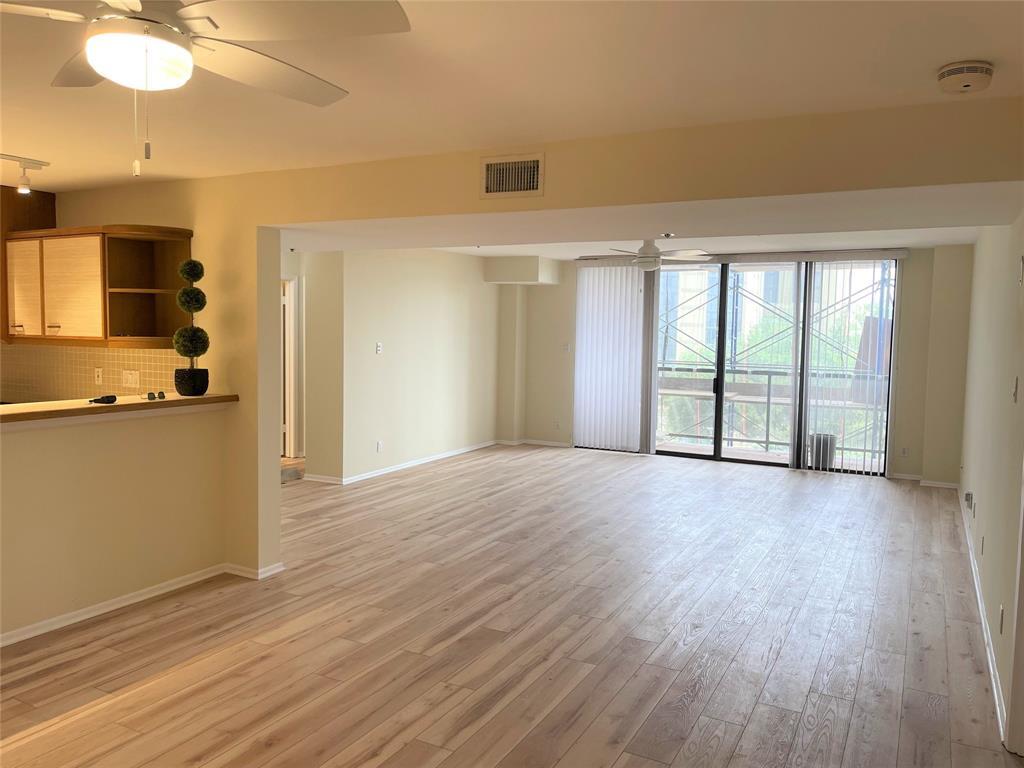
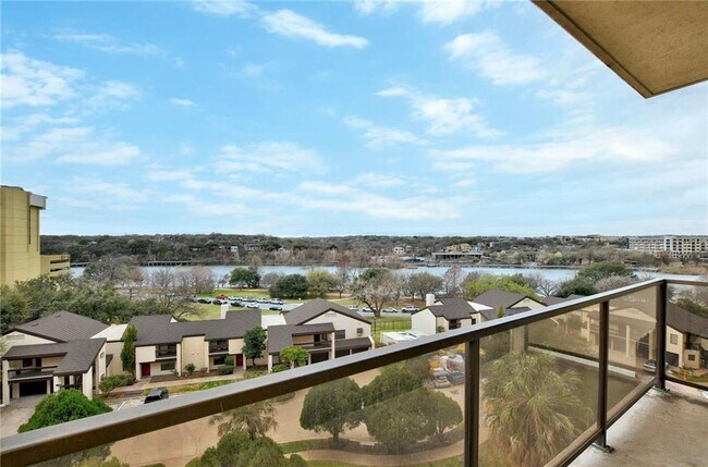
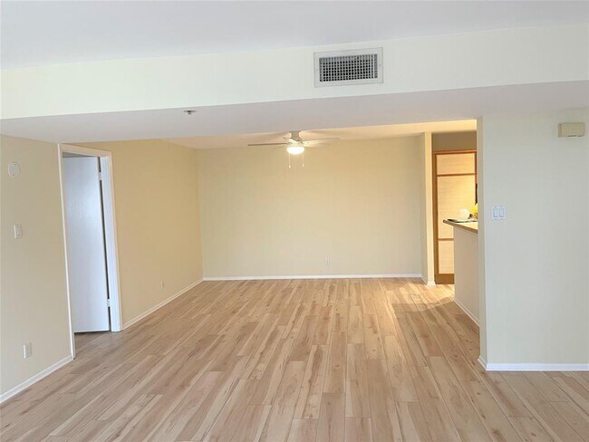
-IMMEDIATE MOVE-IN This newly updated unit in the larger 2/2 floorplan is ready for move in. New paint, flooring (NO CARPET), fixtures in this light bright unit with a view of the lake make this the unit so appealing. Great open kitchen. Towers of Town Lake has all the amenities without the typical downtown price! Walk to Rainey St, the Hike and Bike Trail, plus walkable to other downtown restaurants and venues. Indoor and outdoor pools, fitness center, gated with 24-hour security.
40 N Interstate Hwy 35 is a condo located in Travis County and the 78701 ZIP Code.
Condo Features
Dishwasher
Microwave
Refrigerator
Disposal
- Dishwasher
- Disposal
- Microwave
- Refrigerator
- Tile Floors
- Balcony
Location
Get Directions
Located about one mile southeast of Downtown Austin, Rainey Street is a historic and entertainment district known for its charming bungalows that have been renovated as laidback bars. The neighborhood is brimming with a variety of personality-laden bars and diverse restaurants and food trucks along Rainey Street, the neighborhood’s self-titled avenue and main thoroughfare.
The Rainey Street District offers plenty of ways to enjoy the outdoors, with access to the Colorado River, Lady Bird Lake, the Ann and Roy Butler Hike and Bike Trail, and Waller Beach at Town Lake Metropolitan Park. Rainey Street is also just across the Congress Avenue Bridge from the Statesman Bat Observation Center. Close proximity to Downtown Austin and I-35 makes getting around from Rainey Street easy.
Learn more about living in Rainey StreetBelow are rent ranges for similar nearby apartments
Amenities
- Dishwasher
- Disposal
- Microwave
- Refrigerator
- Tile Floors
- Balcony
Education
| Colleges & Universities | Distance | ||
|---|---|---|---|
| Colleges & Universities | Distance | ||
| Drive: | 5 min | 2.8 mi | |
| Drive: | 6 min | 2.8 mi | |
| Drive: | 6 min | 3.0 mi | |
| Drive: | 7 min | 3.3 mi |
40 N Interstate Hwy 35 Unit 5D3 is within 6 minutes or 2.8 miles from University of Texas at Austin. It is also near Austin C.C., Rio Grande Campus and St. Edward's University.
Transportation options available in Austin include Downtown Station, located 1.3 miles from 40 N Interstate Hwy 35 Unit 5D3. 40 N Interstate Hwy 35 Unit 5D3 is near Austin-Bergstrom International, located 10.0 miles or 22 minutes away.
| Transit / Subway | Distance | ||
|---|---|---|---|
| Transit / Subway | Distance | ||
| Drive: | 3 min | 1.3 mi | |
| Drive: | 4 min | 1.6 mi | |
| Drive: | 7 min | 3.6 mi | |
| Drive: | 9 min | 6.0 mi | |
| Drive: | 12 min | 6.9 mi |
| Commuter Rail | Distance | ||
|---|---|---|---|
| Commuter Rail | Distance | ||
|
|
Drive: | 7 min | 2.9 mi |
|
|
Drive: | 35 min | 30.0 mi |
|
|
Drive: | 46 min | 37.0 mi |
| Airports | Distance | ||
|---|---|---|---|
| Airports | Distance | ||
|
Austin-Bergstrom International
|
Drive: | 22 min | 10.0 mi |
Time and distance from 40 N Interstate Hwy 35 Unit 5D3.
| Shopping Centers | Distance | ||
|---|---|---|---|
| Shopping Centers | Distance | ||
| Drive: | 3 min | 1.3 mi | |
| Drive: | 4 min | 1.7 mi | |
| Drive: | 4 min | 1.7 mi |
40 N Interstate Hwy 35 Unit 5D3 has 3 shopping centers within 1.7 miles, which is about a 4-minute drive. The miles and minutes will be for the farthest away property.
| Parks and Recreation | Distance | ||
|---|---|---|---|
| Parks and Recreation | Distance | ||
|
Lady Bird Lake
|
Drive: | 3 min | 1.4 mi |
|
Blunn Creek Nature Preserve
|
Drive: | 4 min | 2.3 mi |
|
Umlauf Sculpture Garden and Museum
|
Drive: | 6 min | 2.8 mi |
|
Zilker Botanical Garden
|
Drive: | 7 min | 3.2 mi |
|
Boggy Creek Greenbelt
|
Drive: | 7 min | 3.6 mi |
40 N Interstate Hwy 35 Unit 5D3 has 5 parks within 3.6 miles, including Lady Bird Lake, Blunn Creek Nature Preserve, and Umlauf Sculpture Garden and Museum.
| Hospitals | Distance | ||
|---|---|---|---|
| Hospitals | Distance | ||
| Drive: | 4 min | 2.0 mi | |
| Drive: | 5 min | 3.1 mi | |
| Drive: | 6 min | 3.2 mi |
40 N Interstate Hwy 35 Unit 5D3 has 3 hospitals within 3.2 miles, the nearest is Dell Seton Medical Center at The University of Texas which is 2.0 miles away and a 4 minute drive.
| Military Bases | Distance | ||
|---|---|---|---|
| Military Bases | Distance | ||
| Drive: | 78 min | 65.0 mi | |
| Drive: | 106 min | 92.5 mi |
40 N Interstate Hwy 35 Unit 5D3 is 65.0 miles from Randolph Air Force Base, and is convenient to other military bases, including Camp Bullis Military Training Reservation.
You May Also Like
Similar Rentals Nearby


What Are Walk Score®, Transit Score®, and Bike Score® Ratings?
Walk Score® measures the walkability of any address. Transit Score® measures access to public transit. Bike Score® measures the bikeability of any address.
What is a Sound Score Rating?
A Sound Score Rating aggregates noise caused by vehicle traffic, airplane traffic and local sources

40 N Interstate Hwy 35
Austin, TX 78701