


$800 / Month
3964 Kenkel Ave Unit 4
Cheviot, OH 45211
2 Weeks Ago
Favorites
3964 Kenkel Ave Unit 4

Favorites
Check Back Soon for Upcoming Availability
| Beds | Baths | Average SF |
|---|---|---|
| 1 Bedroom 1 Bedroom 1 Br | 1 Bath 1 Bath 1 Ba | 700 SF |
Fees and Policies
The fees below are based on community-supplied data and may exclude additional fees and utilities.
Details
Utilities Included
-
Water
-
Heat
-
Trash Removal
-
Sewer
Property Information
-
4 units
About This Property
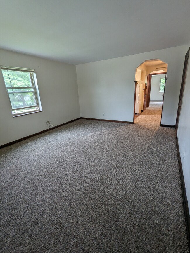
About Kenkel Apartments Welcome to your new home! Carpet floors throughout, spacious and plenty of storage space. The property grants easy access to Harrison Avenue, I-74, and Glenway Avenue which gives its residents a multitude of local restaurants (Chick Fil A, First Watch, Chipotle, etc.), shopping outlets (Lowes, Kroger Marketplace, etc.) and much more only minutes from your doorstep.
3964 Kenkel Ave is an apartment community located in Hamilton County and the 45211 ZIP Code.
Apartment Features
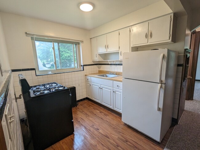
Refrigerator
Tub/Shower
Freezer
Ceiling Fans
- Heating
- Ceiling Fans
- Smoke Free
- Tub/Shower
- Kitchen
- Oven
- Range
- Refrigerator
- Freezer
- Carpet
- Dining Room
- Family Room
- Basement
- Laundry Facilities
- Storage Space
- Yard
- Lawn
Location
Get Directions
Below are rent ranges for similar nearby apartments
Amenities
- Heating
- Ceiling Fans
- Smoke Free
- Tub/Shower
- Kitchen
- Oven
- Range
- Refrigerator
- Freezer
- Carpet
- Dining Room
- Family Room
- Basement
- Laundry Facilities
- Storage Space
- Yard
- Lawn
Expenses
Utilities Included
Water, Heat, Trash Removal, Sewer
Included
Education
| Colleges & Universities | Distance | ||
|---|---|---|---|
| Colleges & Universities | Distance | ||
| Drive: | 14 min | 5.7 mi | |
| Drive: | 17 min | 6.9 mi | |
| Drive: | 16 min | 7.2 mi | |
| Drive: | 17 min | 7.6 mi |
3964 Kenkel Ave Unit 4 is within 14 minutes or 5.7 miles from College of Mount St. Joseph. It is also near Cincinnati State and University of Cincinnati.
Transportation options available in Cheviot include Brewery District Station, Elm & Henry, located 6.8 miles from 3964 Kenkel Ave Unit 4. 3964 Kenkel Ave Unit 4 is near Cincinnati/Northern Kentucky International, located 21.9 miles or 41 minutes away.
| Transit / Subway | Distance | ||
|---|---|---|---|
| Transit / Subway | Distance | ||
| Drive: | 17 min | 6.8 mi | |
| Drive: | 17 min | 7.0 mi | |
| Drive: | 18 min | 7.1 mi | |
| Drive: | 18 min | 7.2 mi | |
| Drive: | 18 min | 7.3 mi |
| Commuter Rail | Distance | ||
|---|---|---|---|
| Commuter Rail | Distance | ||
|
|
Drive: | 17 min | 7.9 mi |
| Airports | Distance | ||
|---|---|---|---|
| Airports | Distance | ||
|
Cincinnati/Northern Kentucky International
|
Drive: | 41 min | 21.9 mi |
Time and distance from 3964 Kenkel Ave Unit 4.
| Shopping Centers | Distance | ||
|---|---|---|---|
| Shopping Centers | Distance | ||
| Walk: | 16 min | 0.9 mi | |
| Walk: | 18 min | 1.0 mi | |
| Drive: | 4 min | 1.1 mi |
3964 Kenkel Ave Unit 4 has 3 shopping centers within 1.1 miles, which is about a 4-minute walk. The miles and minutes will be for the farthest away property.
| Parks and Recreation | Distance | ||
|---|---|---|---|
| Parks and Recreation | Distance | ||
|
Mt. Airy Forest
|
Drive: | 8 min | 3.0 mi |
|
Mitchell Memorial Forest
|
Drive: | 11 min | 4.7 mi |
|
Imago Earth Center
|
Drive: | 15 min | 5.7 mi |
|
Buttercup Valley
|
Drive: | 14 min | 5.9 mi |
|
LaBoiteaux Woods
|
Drive: | 17 min | 7.1 mi |
3964 Kenkel Ave Unit 4 has 5 parks within 7.1 miles, including Mt. Airy Forest, Mitchell Memorial Forest, and Imago Earth Center.
| Hospitals | Distance | ||
|---|---|---|---|
| Hospitals | Distance | ||
| Drive: | 8 min | 2.7 mi | |
| Drive: | 14 min | 6.5 mi | |
| Drive: | 17 min | 7.7 mi |
3964 Kenkel Ave Unit 4 has 3 hospitals within 7.7 miles, the nearest is Mercy Health - West Hospital which is 2.7 miles away and a 8 minute drive.
| Military Bases | Distance | ||
|---|---|---|---|
| Military Bases | Distance | ||
| Drive: | 77 min | 56.7 mi | |
| Drive: | 83 min | 61.7 mi | |
| Drive: | 85 min | 65.0 mi |
3964 Kenkel Ave Unit 4 has 3 military bases within 65.0 miles, the nearest is Gentile Air Force Station which is 56.7 miles away and a 77 minute drive.
You May Also Like
Similar Rentals Nearby


What Are Walk Score®, Transit Score®, and Bike Score® Ratings?
Walk Score® measures the walkability of any address. Transit Score® measures access to public transit. Bike Score® measures the bikeability of any address.
What is a Sound Score Rating?
A Sound Score Rating aggregates noise caused by vehicle traffic, airplane traffic and local sources
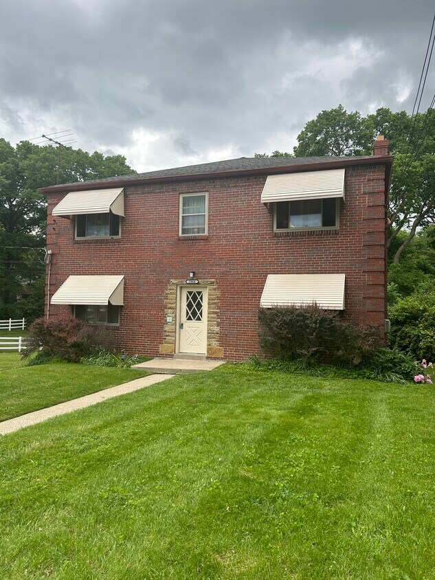
3964 Kenkel Ave
Cheviot, OH 45211