
$4,500 / Month
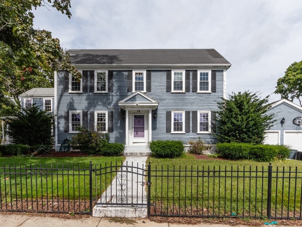
39 Minot St
Boston, MA 02122
2 Weeks Ago
Favorites
39 Minot St

Favorites
Check Back Soon for Upcoming Availability
| Beds | Baths | Average SF |
|---|---|---|
| 3 Bedrooms 3 Bedrooms 3 Br | 2.5 Baths 2.5 Baths 2.5 Ba | 6,418 SF |
About This Property
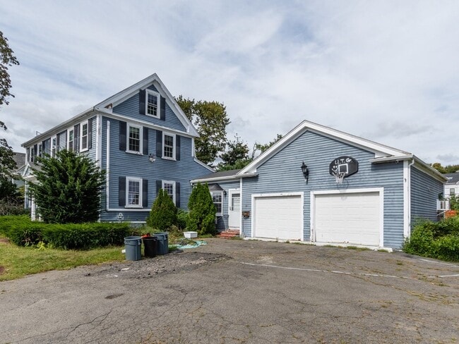
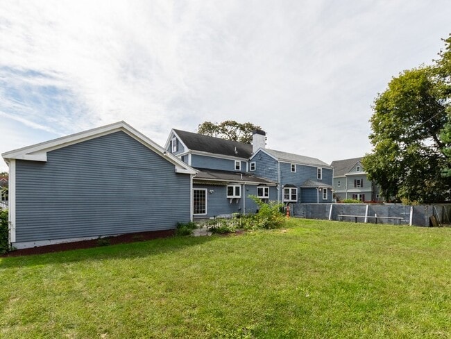
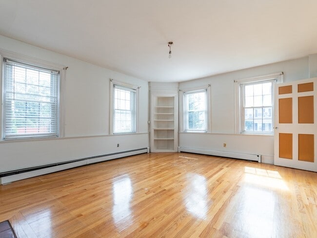
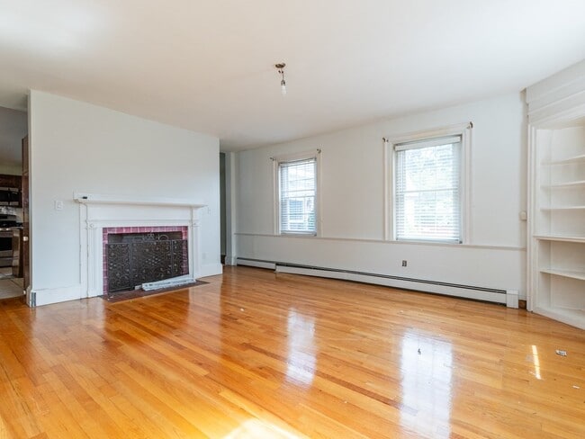
MASSIVE 3 bed,2.5 bath home centrally located in Dorchester! This single family has over 6000 square feet of living space. Complete with garage parking,driveway parking,and a large backyard. This home is a dream come true for would-be buyers who have become renters this past year! Get all the luxuries of single-family living in Dorchester at an extremely reasonable price. This single-family offers everything you are looking for in the city. Conveniently located minutes from I-93,and nearby Redline access. Just down the street from beloved Adam's Village,and local hotspots such as Greenhills Irish Bakery,Landmark Public House,and Lucy's American Tavern.
39 Minot St is a house located in Suffolk County and the 02122 ZIP Code. This area is served by the Boston Public Schools attendance zone.
Location
Get Directions
Revel in the classic New England seaside atmosphere in Neponset-Port Norfolk. A stroll down the hilly lanes brings you past weathered historic buildings, many divided into apartments. Residential blocks take up most of the neighborhood; if you want to be near the action, look for homes near the collection of businesses that cluster at the intersection of Adams Street and Gallivan Boulevard.
Although downtown Boston lies just seven miles north, Neponset-Port Norfolk residents enjoy numerous activities close to home. Tenean Beach comes to life in the summer with swimmers and sunbathers, and the Fiddlehead Theatre Company entertains locals with musicals year-round. Go for a run on the waterfront Neponset Trail, or stop by Hemenway Park for the playground and basketball courts.
At mealtime, locals know to find the neighborhood's best clam chowder and pulled pork sandwiches at the Lambert's Rainbow Fruit deli counter. For artisan pizza, try the Bocca or the Lucca at Molinari's.
Learn more about living in Neponset-Port NorfolkBelow are rent ranges for similar nearby apartments
| Beds | Average Size | Lowest | Typical | Premium |
|---|---|---|---|---|
| Studio Studio Studio | 466 Sq Ft | $2,055 | $2,587 | $2,753 |
| 1 Bed 1 Bed 1 Bed | 1571-1602 Sq Ft | $1,900 | $2,583 | $3,250 |
| 2 Beds 2 Beds 2 Beds | 2353 Sq Ft | $2,200 | $3,057 | $4,479 |
| 3 Beds 3 Beds 3 Beds | 1362 Sq Ft | $1,310 | $3,317 | $7,900 |
| 4 Beds 4 Beds 4 Beds | 1716 Sq Ft | $4,200 | $4,467 | $4,700 |
Education
| Colleges & Universities | Distance | ||
|---|---|---|---|
| Colleges & Universities | Distance | ||
| Drive: | 7 min | 2.9 mi | |
| Drive: | 10 min | 5.4 mi | |
| Drive: | 10 min | 5.6 mi | |
| Drive: | 10 min | 5.8 mi |
39 Minot St is within 7 minutes or 2.9 miles from UMass Boston. It is also near Northeastern University and Wentworth Inst. of Technology.
Schools


Public Elementary & Middle School
Grades PK-8
836 Students
Attendance Zone
Public Elementary School
Grades PK-6
316 Students
Attendance Zone
Public Middle School
Grades 6-8
323 Students
Attendance Zone
Public Middle & High School
Grades 6-12
871 Students
Attendance Zone
Public High School
Grades 9-12
42 Students
Attendance Zone
Public High School
Grades 9-12
347 Students
Attendance Zone
Private Elementary & Middle School
Grades PK-8
1,052 Students
Nearby
Private Elementary School
Grades PK-6
206 Students
Nearby
Private High School
Grades 9-12
95 Students
Nearby
School data provided by
 The GreatSchools Rating helps parents compare schools within a state based on a variety of school quality indicators and provides a helpful picture of how effectively each school serves all of its students. Ratings are on a scale of 1 (below average) to 10 (above average) and can include test scores, college readiness, academic progress, advanced courses, equity, discipline and attendance data. We also advise parents to visit schools, consider other information on school performance and programs, and consider family needs as part of the school selection process.
View GreatSchools Rating Methodology
Data provided by GreatSchools.org © 2025. All rights reserved.
View GreatSchools Rating Methodology
Data provided by GreatSchools.org © 2025. All rights reserved.
Transportation options available in Boston include Cedar Grove Station, located 1.1 miles from 39 Minot St. 39 Minot St is near General Edward Lawrence Logan International, located 8.3 miles or 14 minutes away.
| Transit / Subway | Distance | ||
|---|---|---|---|
| Transit / Subway | Distance | ||
|
|
Drive: | 2 min | 1.1 mi |
|
|
Drive: | 3 min | 1.3 mi |
|
|
Drive: | 4 min | 1.5 mi |
|
|
Drive: | 4 min | 1.7 mi |
|
|
Drive: | 4 min | 2.3 mi |
| Commuter Rail | Distance | ||
|---|---|---|---|
| Commuter Rail | Distance | ||
|
|
Drive: | 3 min | 2.4 mi |
| Drive: | 7 min | 2.5 mi | |
| Drive: | 5 min | 2.6 mi | |
|
|
Drive: | 6 min | 3.3 mi |
|
|
Drive: | 7 min | 4.2 mi |
| Airports | Distance | ||
|---|---|---|---|
| Airports | Distance | ||
|
General Edward Lawrence Logan International
|
Drive: | 14 min | 8.3 mi |
Time and distance from 39 Minot St.
| Shopping Centers | Distance | ||
|---|---|---|---|
| Shopping Centers | Distance | ||
| Walk: | 8 min | 0.4 mi | |
| Walk: | 13 min | 0.7 mi | |
| Drive: | 4 min | 1.5 mi |
39 Minot St has 3 shopping centers within 1.5 miles, which is about a 4-minute walk. The miles and minutes will be for the farthest away property.
| Parks and Recreation | Distance | ||
|---|---|---|---|
| Parks and Recreation | Distance | ||
|
Squantum Point Park
|
Drive: | 6 min | 2.3 mi |
|
Dorchester Shores Reservation
|
Drive: | 6 min | 2.9 mi |
|
Adams National Historical Park
|
Drive: | 7 min | 3.2 mi |
|
Franklin Park Zoo
|
Drive: | 7 min | 4.2 mi |
|
Lower Neponset River Trail
|
Drive: | 7 min | 4.3 mi |
39 Minot St has 5 parks within 4.3 miles, including Squantum Point Park, Dorchester Shores Reservation, and Lower Neponset River Trail.
| Hospitals | Distance | ||
|---|---|---|---|
| Hospitals | Distance | ||
| Drive: | 2 min | 1.4 mi | |
| Drive: | 6 min | 3.6 mi | |
| Drive: | 7 min | 4.4 mi |
39 Minot St has 3 hospitals within 4.4 miles, the nearest is Carney Hospital which is 1.4 miles away and a 2 minute drive.
You May Also Like
Similar Rentals Nearby


What Are Walk Score®, Transit Score®, and Bike Score® Ratings?
Walk Score® measures the walkability of any address. Transit Score® measures access to public transit. Bike Score® measures the bikeability of any address.
What is a Sound Score Rating?
A Sound Score Rating aggregates noise caused by vehicle traffic, airplane traffic and local sources

39 Minot St
Boston, MA 02122