


$2,395
/ Month
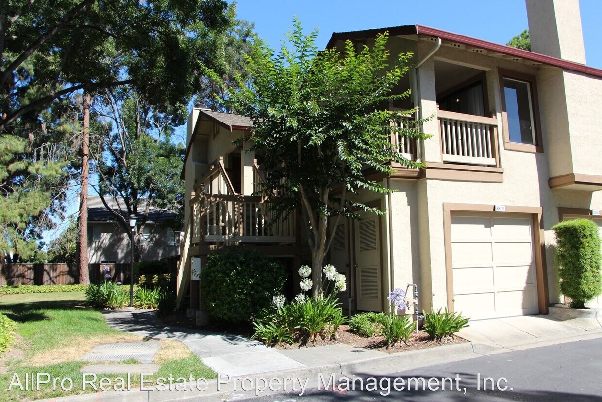
38751 Huntington Cir
Fremont, CA 94536
2 Weeks Ago
|
Edit
Favorites
38751 Huntington Cir

Favorites
Check Back Soon for Upcoming Availability
| Beds | Baths | Average SF |
|---|---|---|
| 2 Bedrooms 2 Bedrooms 2 Br | 2 Baths 2 Baths 2 Ba | 900 SF |
About This Property
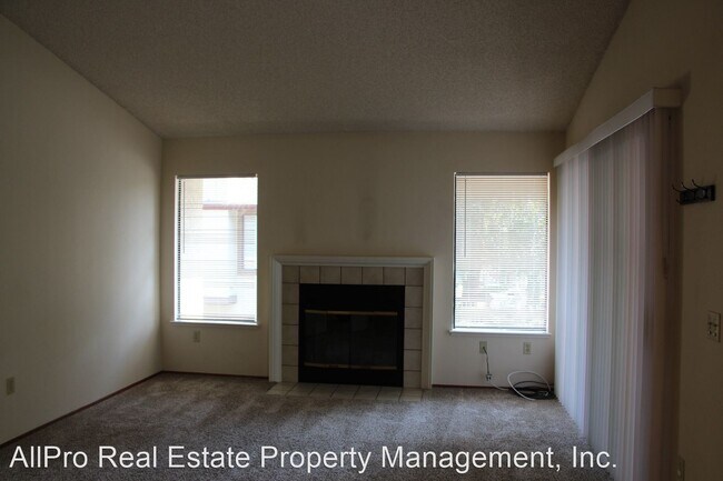
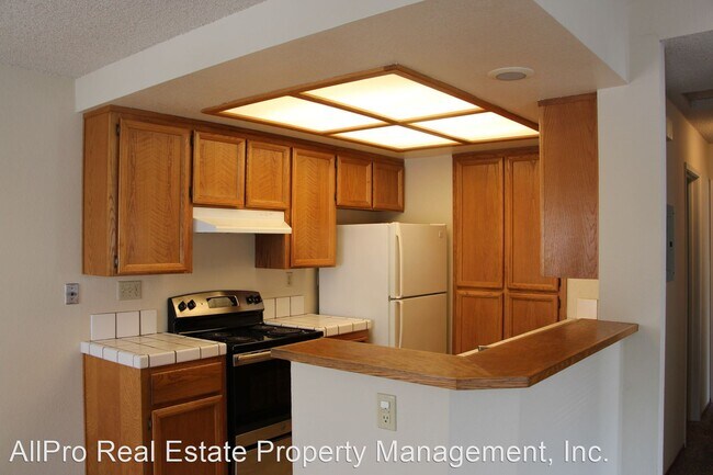
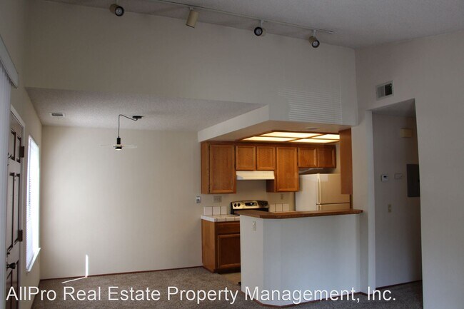
(510) 657-9946 - 38751 Huntington Circle 2 Bed 2 Bath - Two bedroom two bath bright upper end townhouse located at the Orchards. Unit includes new appliances, carpet, fresh paint, blinds and a one car garage. The complex is walking distance to Lake Elizabeth, Bart, transportation and shopping.12 month minimum. Virtual tour: https://www.zillow.com/view-3d-home/6a5b966b-9657-4cd8-9432-f35db5b4bdd2/?utm_source=captureapp (RLNE5051435)
38751 Huntington Cir is a house located in Alameda County and the 94536 ZIP Code. This area is served by the Fremont Unified attendance zone.
Location
Get Directions
Featuring rolling hills that shape a picturesque backdrop, Cherry-Guardino is a suburban neighborhood a few blocks northwest of Downtown Fremont. Complement by manicured lawns and palm-tree-lined streets, Cherry Guardino features mid-range to upscale rentals in a variety of styles, including large single-family homes and modern apartments. A great option for families and professionals, Cherry-Guardino is home to several schools, childcare centers, medical offices, and technology companies. Residents enjoy easy access to nearby restaurants and shopping centers located in Downtown Fremont. Conveniently, a Bay Area Rapid Transit system station at the edge of the neighborhood provides a gateway to the other major cities in the Bay Area, allowing for an easier trip for Silicon Valley commuters.
Learn more about living in Cherry-GuardinoBelow are rent ranges for similar nearby apartments
Education
| Colleges & Universities | Distance | ||
|---|---|---|---|
| Colleges & Universities | Distance | ||
| Drive: | 10 min | 4.6 mi | |
| Drive: | 11 min | 4.9 mi | |
| Drive: | 20 min | 10.0 mi | |
| Drive: | 21 min | 12.6 mi |
38751 Huntington Cir is within 10 minutes or 4.6 miles from Ohlone College, Newark. It is also near Ohlone College, Fremont Campus and Cal State East Bay.
Schools


Public Elementary School
Grades 1-5
403 Students
Attendance Zone
Public Elementary School
Grades K-5
343 Students
Nearby
Public Middle School
Grades 6-8
946 Students
Attendance Zone
Public High School
Grades 9-12
1,931 Students
Attendance Zone
Private Elementary & Middle School
Grades K-8
Nearby
Private Elementary & Middle School
Grades PK-8
194 Students
Nearby
Private Middle & High School
Grades 7-12
27 Students
Nearby
School data provided by
 The GreatSchools Rating helps parents compare schools within a state based on a variety of school quality indicators and provides a helpful picture of how effectively each school serves all of its students. Ratings are on a scale of 1 (below average) to 10 (above average) and can include test scores, college readiness, academic progress, advanced courses, equity, discipline and attendance data. We also advise parents to visit schools, consider other information on school performance and programs, and consider family needs as part of the school selection process.
View GreatSchools Rating Methodology
Data provided by GreatSchools.org © 2025. All rights reserved.
View GreatSchools Rating Methodology
Data provided by GreatSchools.org © 2025. All rights reserved.
Transportation options available in Fremont include Fremont, located 0.8 mile from 38751 Huntington Cir. 38751 Huntington Cir is near Norman Y Mineta San Jose International, located 18.6 miles or 27 minutes away, and Metro Oakland International, located 21.3 miles or 31 minutes away.
| Transit / Subway | Distance | ||
|---|---|---|---|
| Transit / Subway | Distance | ||
|
|
Walk: | 14 min | 0.8 mi |
|
|
Walk: | 14 min | 0.8 mi |
|
|
Drive: | 11 min | 5.2 mi |
|
|
Drive: | 12 min | 5.6 mi |
|
|
Drive: | 17 min | 8.2 mi |
| Commuter Rail | Distance | ||
|---|---|---|---|
| Commuter Rail | Distance | ||
| Drive: | 6 min | 2.4 mi | |
| Drive: | 6 min | 2.5 mi | |
|
|
Drive: | 21 min | 13.2 mi |
| Drive: | 22 min | 14.7 mi | |
| Drive: | 23 min | 14.8 mi |
| Airports | Distance | ||
|---|---|---|---|
| Airports | Distance | ||
|
Norman Y Mineta San Jose International
|
Drive: | 27 min | 18.6 mi |
|
Metro Oakland International
|
Drive: | 31 min | 21.3 mi |
Time and distance from 38751 Huntington Cir.
| Shopping Centers | Distance | ||
|---|---|---|---|
| Shopping Centers | Distance | ||
| Walk: | 19 min | 1.0 mi | |
| Drive: | 4 min | 1.2 mi | |
| Drive: | 4 min | 1.3 mi |
38751 Huntington Cir has 3 shopping centers within 1.3 miles, which is about a 4-minute walk. The miles and minutes will be for the farthest away property.
| Parks and Recreation | Distance | ||
|---|---|---|---|
| Parks and Recreation | Distance | ||
|
Central Park (Lake Elizabeth)
|
Drive: | 5 min | 1.1 mi |
|
Niles Canyon Railway
|
Drive: | 5 min | 2.3 mi |
|
Niles Community Park
|
Drive: | 7 min | 2.8 mi |
|
Quarry Lakes Regional Recreation Area
|
Drive: | 7 min | 3.3 mi |
|
Alameda Creek Regional Trail
|
Drive: | 7 min | 3.5 mi |
38751 Huntington Cir has 5 parks within 3.5 miles, including Central Park (Lake Elizabeth), Niles Canyon Railway, and Niles Community Park.
| Hospitals | Distance | ||
|---|---|---|---|
| Hospitals | Distance | ||
| Walk: | 20 min | 1.0 mi | |
| Drive: | 3 min | 1.2 mi | |
| Drive: | 18 min | 10.4 mi |
38751 Huntington Cir has 3 hospitals within 10.4 miles, the nearest is Washington Hospital which is 1.0 miles away and a 20 minute walk.
| Military Bases | Distance | ||
|---|---|---|---|
| Military Bases | Distance | ||
| Drive: | 32 min | 21.4 mi |
38751 Huntington Cir is 21.4 miles and a 32 minute drive from Ames Research Center.
You May Also Like
Similar Rentals Nearby
-
-

-

-

-

-

-

-
1 / 25

-
-


What Are Walk Score®, Transit Score®, and Bike Score® Ratings?
Walk Score® measures the walkability of any address. Transit Score® measures access to public transit. Bike Score® measures the bikeability of any address.
What is a Sound Score Rating?
A Sound Score Rating aggregates noise caused by vehicle traffic, airplane traffic and local sources
38751 Huntington Cir
Fremont, CA 94536