
$5,000 / Month
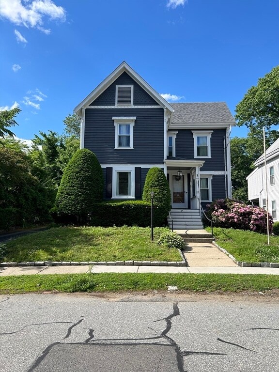
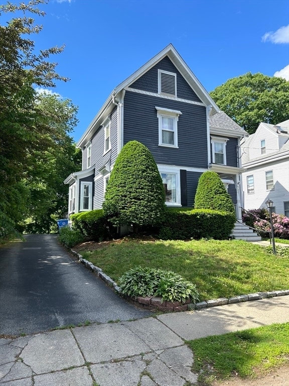
37 Burnham St
Belmont, MA 02478
Today
Favorites
617-840-9304
-
Bedrooms
4
-
Bathrooms
1.5
-
Square Feet
2,053 sq ft
-
Available
Available Sep 1
Highlights
- Deck
- Fenced Yard
- Enclosed patio or porch
- No Cooling
- 2 Car Garage
- Laundry Facilities
37 Burnham St

Favorites
About This Home
$5,000 deposit,
Available Sep 1
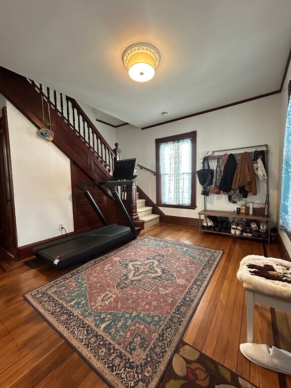
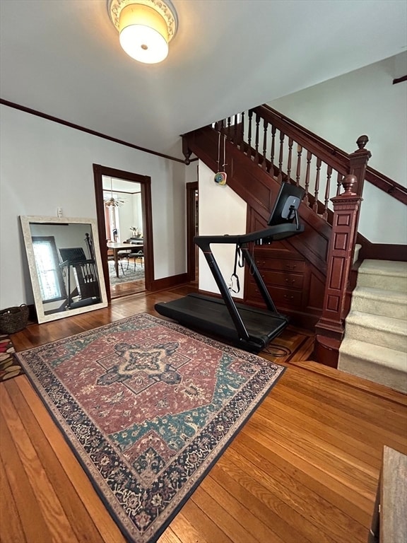
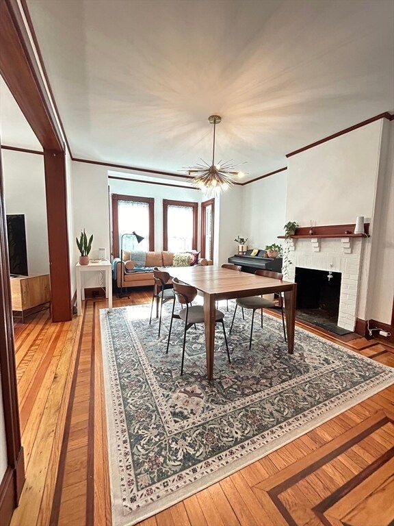
This is a great home for those seeking a blend of historic charm and modern convenience! In a community that US News & World Report ranked the #16 High School in the state,this property offers plenty of space for living and entertaining. There are 4 generously sized bedrooms,1.5 baths,a newly renovated kitchen,and both an expansive living room and dining room to host guests,work from home,or relax among the original period details and hardwood floors. With a driveway that can accommodate 6 cars AND a 2-car garage,there is plenty of parking and storage. The large yard and rear deck are ideal for outdoor entertaining and enjoyment. For those cozy winter months,the enclosed sunroom provides natural light year-round. Located moments to the Daniel Butler Elementary School,Waverly Train Station,Tatte Bakery,Star Market grocery store,and Beaver Brook Reservation,this location is incredibly convenient. Easy access to Boston in a superb town: don't miss the opportunity at hand! MLS# 73385198
37 Burnham St is a house located in Middlesex County and the 02478 ZIP Code. This area is served by the Belmont attendance zone.
* Price shown is base rent and may not include non-optional fees and utilities.
Price, availability, fees, and any applicable rent special are subject to change without notice.
* Square footage definitions vary. Displayed square footage is approximate.
Home Details
Home Type
Single Family Detached Home
Year Built
Built in 1890
Accessible Home Design
Entry on the 1st floor
Basement
Laundry in Basement
Bedrooms and Bathrooms
Primary bedroom located on second floor
1.5 Bathrooms
4 Bedrooms
Interior Spaces
2,053 Sq Ft Home
Kitchen
Range<<rangeHoodToken>>
<<microwave>>
Dishwasher
Laundry
Dryer
Washer
Listing and Financial Details
Security Deposit $5,000
Property Available on 9/1/25
12 Month Lease Term
Assessor Parcel Number 359950
Rent includes water, sewer, trash collection, occupancy only, air conditioning, laundry facilities, parking
Lot Details
Fenced Yard
Fenced
Outdoor Features
Deck
Enclosed patio or porch
Parking
2 Car Garage
Utilities
No Cooling
Heating System Uses Natural Gas
Community Details
Amenities
Laundry Facilities
Overview
No Home Owners Association
Pet Policy
Call for details about the types of pets allowed
Fees and Policies
The fees below are based on community-supplied data and may exclude additional fees and utilities.
Pet policies are negotiable.
Contact
- Listed by TEAM BRUSIL | Keller Williams Realty Boston-Metro - Back Bay
- Phone Number
-
Source
 MLS Property Information Network
The property listing data and information set forth herein were provided to MLS Property Information Network, Inc. from third party sources, including sellers, lessors and public records, and were compiled by MLS Property Information Network, Inc. The property listing data and information are for the personal, non-commercial use of consumers having a good faith interest in purchasing or leasing listed properties of the type displayed to them and may not be used for any purpose other than to identify prospective properties which such consumers may have a good faith interest in purchasing or leasing. MLS Property Information Network, Inc. and its subscribers disclaim any and all representations and warranties as to the accuracy of the property listing data and information set forth herein. All properties are subject to prior sale, change or withdrawal. Copyright © 2025 MLS Property Information Network, Inc. All rights reserved.
Location
Get Directions
Amenities
- Dishwasher
- Microwave
- Range
- Refrigerator
- Fenced Lot
- Patio
- Porch
- Deck
Situated on Cambridge’s western border, about eight miles from Downtown Boston, Belmont is a picturesque suburb boasting a close-knit, small-town feel. Primarily a residential community, Belmont is known to locals as “the Town of Homes” with beautiful houses lining the Pleasant Street Historic District. Local businesses and popular chains also populate Leonard Street’s commercial corridor in Belmont.
Belmont offers residents easy access to Downtown Boston via the T and major roadways in addition to scenic natural surroundings. Convenience to Beaver Brook North Reservation, Rock Meadow Conservation Area, Lone Tree Hill, Claypit Pond, and Robbins Farm Park allows Belmont residents the opportunity to connect with nature at any time while nearby Harvard Square and Downtown Boston present endless options for metropolitan endeavors as well.
Learn more about living in Belmont
Education
| Colleges & Universities | Distance | ||
|---|---|---|---|
| Colleges & Universities | Distance | ||
| Drive: | 5 min | 1.9 mi | |
| Drive: | 10 min | 4.7 mi | |
| Drive: | 12 min | 5.1 mi | |
| Drive: | 13 min | 5.7 mi |
37 Burnham St is within 5 minutes or 1.9 miles from Bentley University. It is also near Boston College, Brighton and Lesley University.
Schools


Public Elementary School
Grades K-4
334 Students
Attendance Zone
Public Elementary & Middle School
Grades 5-8
1,371 Students
Attendance Zone
Public Elementary School
Grades K-5
355 Students
Nearby
Public High School
Grades 9-12
1,364 Students
Attendance Zone
Private Elementary School
Grades K
Nearby
Private Elementary School
Grades PK-1
Nearby
Private Elementary, Middle & High School
Grades 5-12
27 Students
Nearby
Private Elementary & Middle School
Grades PK-8
292 Students
Nearby
Private High School
Grades 9-12
28 Students
Nearby
School data provided by
 The GreatSchools Rating helps parents compare schools within a state based on a variety of school quality indicators and provides a helpful picture of how effectively each school serves all of its students. Ratings are on a scale of 1 (below average) to 10 (above average) and can include test scores, college readiness, academic progress, advanced courses, equity, discipline and attendance data. We also advise parents to visit schools, consider other information on school performance and programs, and consider family needs as part of the school selection process.
View GreatSchools Rating Methodology
Data provided by GreatSchools.org © 2025. All rights reserved.
View GreatSchools Rating Methodology
Data provided by GreatSchools.org © 2025. All rights reserved.
Transportation options available in Belmont include Alewife Station, located 3.8 miles from 37 Burnham St. 37 Burnham St is near General Edward Lawrence Logan International, located 12.4 miles or 22 minutes away.
| Transit / Subway | Distance | ||
|---|---|---|---|
| Transit / Subway | Distance | ||
|
|
Drive: | 8 min | 3.8 mi |
| Drive: | 7 min | 3.8 mi | |
|
|
Drive: | 11 min | 5.0 mi |
|
|
Drive: | 12 min | 5.3 mi |
|
|
Drive: | 12 min | 5.5 mi |
| Commuter Rail | Distance | ||
|---|---|---|---|
| Commuter Rail | Distance | ||
|
|
Walk: | 8 min | 0.4 mi |
|
|
Drive: | 3 min | 1.5 mi |
|
|
Drive: | 6 min | 2.8 mi |
| Drive: | 6 min | 2.9 mi | |
|
|
Drive: | 7 min | 3.6 mi |
| Airports | Distance | ||
|---|---|---|---|
| Airports | Distance | ||
|
General Edward Lawrence Logan International
|
Drive: | 22 min | 12.4 mi |
Time and distance from 37 Burnham St.
| Shopping Centers | Distance | ||
|---|---|---|---|
| Shopping Centers | Distance | ||
| Drive: | 2 min | 1.2 mi | |
| Drive: | 4 min | 1.8 mi | |
| Drive: | 4 min | 1.9 mi |
37 Burnham St has 3 shopping centers within 1.9 miles, which is about a 4-minute drive. The miles and minutes will be for the farthest away property.
| Parks and Recreation | Distance | ||
|---|---|---|---|
| Parks and Recreation | Distance | ||
|
Beaver Brook Reservation
|
Walk: | 13 min | 0.7 mi |
|
Mass Audubon's Habitat Education Center and Wildlife Sanctuary
|
Drive: | 7 min | 2.6 mi |
|
Longfellow National Historic Site
|
Drive: | 8 min | 3.7 mi |
|
Harvard-Smithsonian Center for Astrophysics
|
Drive: | 9 min | 3.8 mi |
|
Harvard Museum of Natural History
|
Drive: | 11 min | 4.8 mi |
37 Burnham St has 5 parks within 4.8 miles, including Beaver Brook Reservation, Mass Audubon's Habitat Education Center and Wildlife Sanctuary, and Longfellow National Historic Site.
| Hospitals | Distance | ||
|---|---|---|---|
| Hospitals | Distance | ||
| Walk: | 18 min | 0.9 mi | |
| Drive: | 6 min | 3.2 mi | |
| Drive: | 7 min | 3.7 mi |
37 Burnham St has 3 hospitals within 3.7 miles, the nearest is McLean Hospital Corporation which is 0.9 mile away and a 18 minute walk.
| Military Bases | Distance | ||
|---|---|---|---|
| Military Bases | Distance | ||
| Drive: | 17 min | 8.2 mi | |
| Drive: | 25 min | 14.1 mi |
37 Burnham St is 8.2 miles from Hanscom Air Force Base, and is convenient to other military bases, including US Military Reservation.
You May Also Like
Similar Rentals Nearby


What Are Walk Score®, Transit Score®, and Bike Score® Ratings?
Walk Score® measures the walkability of any address. Transit Score® measures access to public transit. Bike Score® measures the bikeability of any address.
What is a Sound Score Rating?
A Sound Score Rating aggregates noise caused by vehicle traffic, airplane traffic and local sources

37 Burnham St
Belmont, MA 02478