
Fourth and U
2020 4th St,
Berkeley, CA 94710
$2,481 - $3,463
1-2 Beds


City of Oakland Alameda County Walk to outstanding Dimond District commercial area shops, super markets, restaurants, bars, coffee houses Upper Fruitvale neighborhood, near Glenview Dimond Park, one of the most beautiful parks in Oakland is just a block away Minutes to San Francisco, Berkeley, Hayward, and San Leandro Quick access to major highways 580, 880, 24, and 13 Approximately near Fruitvale BART Bus stops for AC Transit nearby on MacArthur Blvd. Close to Casual Carpool at the intersection of Fruitvale and Montana St.
3600 Dimond Ave is an apartment community located in Alameda County and the 94602 ZIP Code. This area is served by the Oakland Unified attendance zone.
Unique Features
Granite Countertops
Smoke Free
Heating
Kitchen
Oakland combines city living with natural beauty across its diverse neighborhoods. The downtown area showcases restored Art Deco architecture alongside a flourishing arts scene, while Lake Merritt, the nation's first wildlife refuge, offers paths for jogging, spots for picnicking, and opportunities for wildlife watching. From the Victorian homes in Adams Point to apartments in Uptown, residents live near landmarks like the historic Fox Theater. The Oakland Hills provide sweeping Bay views and access to Redwood Regional Park's majestic forest trails. The Jack London Square district features waterfront restaurants and entertainment, while the Mills College campus adds to the city's educational landscape.
Oakland's rental market remains competitive, with one-bedroom apartments averaging $2,076 and two-bedroom units at $2,675, showing year-over-year increases of 0.3% and 0.9% respectively.
Learn more about living in OaklandCompare neighborhood and city base rent averages by bedroom.
| Lower Hills District | Oakland, CA | |
|---|---|---|
| Studio | $1,501 | $1,704 |
| 1 Bedroom | $1,577 | $2,087 |
| 2 Bedrooms | $1,871 | $2,677 |
| 3 Bedrooms | $2,805 | $3,219 |
| Colleges & Universities | Distance | ||
|---|---|---|---|
| Colleges & Universities | Distance | ||
| Drive: | 8 min | 2.8 mi | |
| Drive: | 6 min | 3.1 mi | |
| Drive: | 8 min | 3.6 mi | |
| Drive: | 7 min | 3.8 mi |


Transportation options available in Oakland include Fruitvale Station, located 2.2 miles from 3600 Dimond Ave. 3600 Dimond Ave is near Metro Oakland International, located 8.1 miles or 14 minutes away, and San Francisco International, located 25.4 miles or 37 minutes away.
| Transit / Subway | Distance | ||
|---|---|---|---|
| Transit / Subway | Distance | ||
|
|
Drive: | 5 min | 2.2 mi |
|
|
Drive: | 8 min | 3.6 mi |
|
|
Drive: | 8 min | 3.6 mi |
|
|
Drive: | 8 min | 3.6 mi |
|
|
Drive: | 7 min | 3.9 mi |
| Commuter Rail | Distance | ||
|---|---|---|---|
| Commuter Rail | Distance | ||
|
|
Drive: | 9 min | 3.9 mi |
|
|
Drive: | 10 min | 6.4 mi |
|
|
Drive: | 12 min | 8.5 mi |
| Drive: | 19 min | 12.9 mi | |
| Drive: | 19 min | 13.0 mi |
| Airports | Distance | ||
|---|---|---|---|
| Airports | Distance | ||
|
Metro Oakland International
|
Drive: | 14 min | 8.1 mi |
|
San Francisco International
|
Drive: | 37 min | 25.4 mi |
Time and distance from 3600 Dimond Ave.
| Shopping Centers | Distance | ||
|---|---|---|---|
| Shopping Centers | Distance | ||
| Walk: | 6 min | 0.3 mi | |
| Drive: | 6 min | 2.8 mi | |
| Drive: | 6 min | 2.9 mi |
| Parks and Recreation | Distance | ||
|---|---|---|---|
| Parks and Recreation | Distance | ||
|
Lakeside Park
|
Drive: | 5 min | 2.8 mi |
|
Morcom Rose Garden
|
Drive: | 5 min | 2.9 mi |
|
Rotary Nature Center
|
Drive: | 6 min | 3.1 mi |
|
Chabot Space & Science Center
|
Drive: | 12 min | 4.4 mi |
|
Joaquin Miller Park
|
Drive: | 11 min | 4.5 mi |
| Hospitals | Distance | ||
|---|---|---|---|
| Hospitals | Distance | ||
| Walk: | 20 min | 1.1 mi | |
| Walk: | 20 min | 1.1 mi | |
| Drive: | 6 min | 3.4 mi |
| Military Bases | Distance | ||
|---|---|---|---|
| Military Bases | Distance | ||
| Drive: | 16 min | 7.0 mi | |
| Drive: | 16 min | 8.9 mi |
What Are Walk Score®, Transit Score®, and Bike Score® Ratings?
Walk Score® measures the walkability of any address. Transit Score® measures access to public transit. Bike Score® measures the bikeability of any address.
What is a Sound Score Rating?
A Sound Score Rating aggregates noise caused by vehicle traffic, airplane traffic and local sources
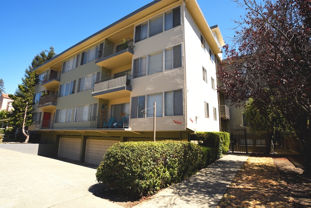
3600 Dimond Ave
Oakland, CA 94602


