

$2,095
/ Month
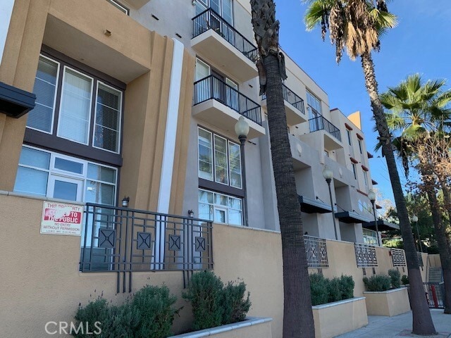
360 W Ave 26
Los Angeles, CA 90031
Today
Favorites
909-532-8866
-
Bedrooms
Studio
-
Bathrooms
1
-
Square Feet
630 sq ft
-
Available
Available Now
Highlights
- City Lights View
- Living Room
- Laundry Room
- Central Heating and Cooling System
- Dogs and Cats Allowed
- Stacked Washer and Dryer
360 W Ave 26

Favorites
About This Home
12 Month Lease,
$2,095 deposit,
Available Now
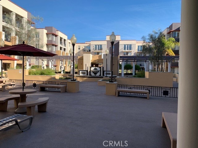
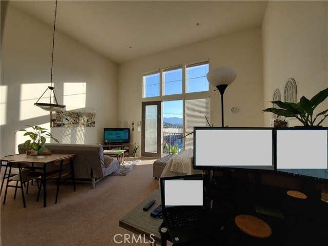
This charming top-floor studio condominium offers 630 sq. ft. of open living space with soaring 12-foot ceilings, floor-to-ceiling windows, and a private balcony showcasing city and mountain views. Features include central air/heat, underground parking, in-unit washer and dryer, and a modern kitchen with stainless steel appliances. The secured, gated community provides access to a fitness center, clubhouse, and recreation room, while its location just off the 5 and 110 Freeways allows easy access to Downtown Los Angeles, Metro stations, and USC Keck Medical Center—all while remaining quiet and peaceful. Renter is responsible for all utilities except trash. Small Pets may be considered with additional $40/month pet rent. MLS# IG25225264
360 W Ave 26 is a house located in Los Angeles County and the 90031 ZIP Code. This area is served by the Los Angeles Unified attendance zone.
* Price shown is base rent. Excludes user-selected optional fees and variable or usage-based fees and required charges due at or prior to move-in or at move-out. Price, availability, fees, and any applicable rent special are subject to change without notice.
* Square footage definitions vary. Displayed square footage is approximate.
Home Details
Year Built
Built in 2006
Bedrooms and Bathrooms
1 Main Level Bedroom
1 Full Bathroom
Home Design
Studio
Multi-Family
Entry on the 4th floor
Interior Spaces
Living Room
630 Sq Ft Home
4-Story Property
Laundry
Laundry Room
Stacked Washer and Dryer
Listing and Financial Details
Security Deposit $2,095
12-Month Minimum Lease Term
Available 11/15/25
Tax Lot 1
Tax Tract Number 60581
Assessor Parcel Number 5205012069
Rent includes trash collection
Lot Details
1.24 Acre Lot
Two or More Common Walls
Outdoor Features
Exterior Lighting
Parking
1 Car Garage
Utilities
Central Heating and Cooling System
Private Water Source
Views
City Lights
Mountain
Community Details
Overview
Property has a Home Owners Association
Pet Policy
Dogs and Cats Allowed
Breed Restrictions
Pet Size Limit
Fees and Policies
The fees below are based on community-supplied data and may exclude additional fees and utilities.
Pet policies are negotiable.
- Dogs Allowed
-
Fees not specified
- Cats Allowed
-
Fees not specified
Details
Utilities Included
-
Trash Removal
Lease Options
-
12 Months
Contact
- Listed by Brent Holmes | Clockwork Property Management
- Phone Number
- Contact
-
Source
 California Regional Multiple Listing Service
Copyright 2025 © California Regional MLS. All rights reserved.
Location
Get Directions
Amenities
- Air Conditioning
- Heating
Expenses
Utilities Included
Trash Removal
Included
Situated in northeast Los Angeles, just four miles from downtown, Montecito Heights sits atop a hilly landscape separating LA from the San Gabriel Valley. From the neighborhood’s steep hills, you can catch stunning views of downtown and the San Gabriel Valley in addition to the Arroyo Seco and even the Pacific Ocean (on a clear day).
Montecito Heights is known for its secluded feel despite being minutes away from Downtown LA. Natural beauty and lush parks abound in Montecito Heights. Ernest E. Debs Regional Park is one of the neighborhood’s defining features, touting 300 acres of scenic hiking trails, biking paths, picnic tables, a peaceful pond, and the striking panoramic views the neighborhood is revered for.
Montecito Heights is also home to the Heritage Square Museum, a living history museum that details life in 19th-century Southern California.
Learn more about living in Montecito Heights
Education
| Colleges & Universities | Distance | ||
|---|---|---|---|
| Colleges & Universities | Distance | ||
| Drive: | 5 min | 2.1 mi | |
| Drive: | 6 min | 3.8 mi | |
| Drive: | 9 min | 4.8 mi | |
| Drive: | 9 min | 5.1 mi |
360 W Ave 26 is within 5 minutes or 2.1 miles from USC, Health Sciences Campus. It is also near Golden Gate Univ, Los Angeles and Occidental College.
Schools


Public Elementary School
Grades K-6
145 Students
Attendance Zone
Charter Elementary School
Grades K-5
75 Students
Nearby
Public Middle School
Grades 6-8
790 Students
Attendance Zone
Public High School
Grades 9-12
1,028 Students
Attendance Zone
Public High School
Grades 9-12
1,406 Students
Attendance Zone
Private Elementary & Middle School
Grades K-8
74 Students
Nearby
Private Elementary, Middle & High School
Grades PK-12
163 Students
Nearby
Private High School
Grades 9-12
279 Students
Nearby
School data provided by
 The GreatSchools Rating helps parents compare schools within a state based on a variety of school quality indicators and provides a helpful picture of how effectively each school serves all of its students. Ratings are on a scale of 1 (below average) to 10 (above average) and can include test scores, college readiness, academic progress, advanced courses, equity, discipline and attendance data. We also advise parents to visit schools, consider other information on school performance and programs, and consider family needs as part of the school selection process.
View GreatSchools Rating Methodology
Data provided by GreatSchools.org © 2025. All rights reserved.
View GreatSchools Rating Methodology
Data provided by GreatSchools.org © 2025. All rights reserved.
Transportation options available in Los Angeles include Lincoln Heights/Cypress Park Station, located 0.1 mile from 360 W Ave 26. 360 W Ave 26 is near Bob Hope, located 14.9 miles or 21 minutes away, and Los Angeles International, located 17.8 miles or 28 minutes away.
| Transit / Subway | Distance | ||
|---|---|---|---|
| Transit / Subway | Distance | ||
|
|
Walk: | 1 min | 0.1 mi |
|
|
Walk: | 18 min | 0.9 mi |
|
|
Drive: | 3 min | 1.8 mi |
|
|
Drive: | 3 min | 2.2 mi |
|
|
Drive: | 7 min | 2.8 mi |
| Commuter Rail | Distance | ||
|---|---|---|---|
| Commuter Rail | Distance | ||
|
|
Drive: | 6 min | 2.8 mi |
|
|
Drive: | 7 min | 2.8 mi |
|
|
Drive: | 7 min | 4.0 mi |
| Drive: | 9 min | 6.9 mi | |
|
|
Drive: | 17 min | 11.0 mi |
| Airports | Distance | ||
|---|---|---|---|
| Airports | Distance | ||
|
Bob Hope
|
Drive: | 21 min | 14.9 mi |
|
Los Angeles International
|
Drive: | 28 min | 17.8 mi |
Time and distance from 360 W Ave 26.
| Shopping Centers | Distance | ||
|---|---|---|---|
| Shopping Centers | Distance | ||
| Walk: | 7 min | 0.4 mi | |
| Walk: | 7 min | 0.4 mi | |
| Walk: | 9 min | 0.5 mi |
360 W Ave 26 has 3 shopping centers within 0.5 mile, which is about a 9-minute walk. The miles and minutes will be for the farthest away property.
| Parks and Recreation | Distance | ||
|---|---|---|---|
| Parks and Recreation | Distance | ||
|
Audubon Center at Debs Park
|
Drive: | 3 min | 1.9 mi |
|
Chavez Ravine Arboretum
|
Drive: | 4 min | 2.5 mi |
|
Elysian Park
|
Drive: | 7 min | 2.6 mi |
|
Elyria Canyon Park
|
Drive: | 6 min | 2.8 mi |
|
Echo Park Lake
|
Drive: | 5 min | 3.4 mi |
360 W Ave 26 has 5 parks within 3.4 miles, including Audubon Center at Debs Park, Elyria Canyon Park, and Elysian Park.
| Hospitals | Distance | ||
|---|---|---|---|
| Hospitals | Distance | ||
| Drive: | 4 min | 2.2 mi | |
| Drive: | 5 min | 2.4 mi | |
| Drive: | 7 min | 3.2 mi |
360 W Ave 26 has 3 hospitals within 3.2 miles, the nearest is LAC + USC Medical Center which is 2.2 miles away and a 4 minute drive.
| Military Bases | Distance | ||
|---|---|---|---|
| Military Bases | Distance | ||
| Drive: | 25 min | 19.4 mi |
360 W Ave 26 is 19.4 miles and a 25 minute drive from Los Angeles Air Force Base.
You May Also Like
Similar Rentals Nearby


What Are Walk Score®, Transit Score®, and Bike Score® Ratings?
Walk Score® measures the walkability of any address. Transit Score® measures access to public transit. Bike Score® measures the bikeability of any address.
What is a Sound Score Rating?
A Sound Score Rating aggregates noise caused by vehicle traffic, airplane traffic and local sources

360 W Ave 26
Los Angeles, CA 90031