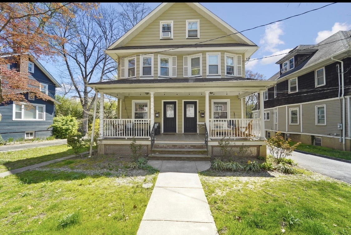
36 Dunnell Rd Unit 36
Maplewood, NJ 07040
-
Bedrooms
4
-
Bathrooms
2
-
Square Feet
1,800 sq ft
-
Available
Available Jul 1
Highlight
- Pets Allowed

36 Dunnell Rd is an apartment community located in Essex County and the 07040 ZIP Code.
Apartment Features
- Washer/Dryer
Fees and Policies
The fees listed below are community-provided and may exclude utilities or add-ons. All payments are made directly to the property and are non-refundable unless otherwise specified.
- Dogs Allowed
-
Fees not specified
- Cats Allowed
-
Fees not specified
Contact
- Contact
Twenty miles west of New York City, Maplewood is a charming suburban township that surrounds its residents with an atmosphere of classic Americana. The rental market is quite diverse, featuring apartments, condos, and single-family homes to suit any taste or lifestyle. Maplewood’s small downtown area, commonly known as The Village, is a timeless walking district containing diverse mix of locally-owned businesses, including restaurants, toy stores, book shops, art galleries, and a historic movie theater.
The beautiful Maplewood Park at the center of town is the perfect spot to spend a relaxing afternoon, with the Maplewood Golf Course right next door. South Mountain Reservation sits along the northwest edge of town, providing a sprawling venue for exploring the region’s natural beauty. The annual Maplewoodstock festival is a major concert event in town, drawing big crowds every 4th of July weekend.
Learn more about living in Maplewood| Colleges & Universities | Distance | ||
|---|---|---|---|
| Colleges & Universities | Distance | ||
| Drive: | 7 min | 2.3 mi | |
| Drive: | 12 min | 5.6 mi | |
| Drive: | 13 min | 5.7 mi | |
| Drive: | 16 min | 6.0 mi |
Transportation options available in Maplewood include Warren Street, located 5.6 miles from 36 Dunnell Rd Unit 36. 36 Dunnell Rd Unit 36 is near Newark Liberty International, located 8.6 miles or 15 minutes away, and LaGuardia, located 27.9 miles or 50 minutes away.
| Transit / Subway | Distance | ||
|---|---|---|---|
| Transit / Subway | Distance | ||
|
|
Drive: | 12 min | 5.6 mi |
|
|
Drive: | 12 min | 5.6 mi |
|
|
Drive: | 12 min | 5.6 mi |
|
|
Drive: | 13 min | 5.8 mi |
|
|
Drive: | 13 min | 6.2 mi |
| Commuter Rail | Distance | ||
|---|---|---|---|
| Commuter Rail | Distance | ||
|
|
Walk: | 11 min | 0.6 mi |
|
|
Drive: | 3 min | 1.4 mi |
|
|
Drive: | 6 min | 2.2 mi |
|
|
Drive: | 7 min | 2.7 mi |
|
|
Drive: | 8 min | 3.2 mi |
| Airports | Distance | ||
|---|---|---|---|
| Airports | Distance | ||
|
Newark Liberty International
|
Drive: | 15 min | 8.6 mi |
|
LaGuardia
|
Drive: | 50 min | 27.9 mi |
Time and distance from 36 Dunnell Rd Unit 36.
| Shopping Centers | Distance | ||
|---|---|---|---|
| Shopping Centers | Distance | ||
| Drive: | 5 min | 1.5 mi | |
| Drive: | 5 min | 1.6 mi | |
| Drive: | 6 min | 1.8 mi |
| Parks and Recreation | Distance | ||
|---|---|---|---|
| Parks and Recreation | Distance | ||
|
Greenwood Gardens
|
Drive: | 10 min | 4.1 mi |
|
Cora Hartshorn Arboretum
|
Drive: | 12 min | 4.2 mi |
|
Edison National Historic Site
|
Drive: | 12 min | 4.4 mi |
|
Turtle Back Zoo
|
Drive: | 10 min | 4.5 mi |
|
Reeves-Reed Arboretum
|
Drive: | 12 min | 5.3 mi |
| Hospitals | Distance | ||
|---|---|---|---|
| Hospitals | Distance | ||
| Drive: | 9 min | 4.0 mi | |
| Drive: | 9 min | 4.0 mi | |
| Drive: | 10 min | 4.2 mi |
| Military Bases | Distance | ||
|---|---|---|---|
| Military Bases | Distance | ||
| Drive: | 21 min | 12.5 mi | |
| Drive: | 26 min | 13.0 mi | |
| Drive: | 24 min | 13.3 mi |
- Washer/Dryer
36 Dunnell Rd Unit 36 Photos
Statewide service is free, confidential, multilingual and always open. Three easy ways to reach Social Services in NJ: Dial 2-1-1; text your zip code to 898-211; or chat at https://www.nj211.org
What Are Walk Score®, Transit Score®, and Bike Score® Ratings?
Walk Score® measures the walkability of any address. Transit Score® measures access to public transit. Bike Score® measures the bikeability of any address.
What is a Sound Score Rating?
A Sound Score Rating aggregates noise caused by vehicle traffic, airplane traffic and local sources.

36 Dunnell Rd
Maplewood, NJ 07040