-
FamilyHome
-
-
-
$2,500
/ Month
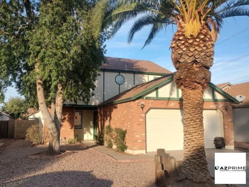
3458 N Apache Ct
Chandler, AZ 85224
Today
|
Edit
Favorites
480-449-6632
-
Bedrooms
3
-
Bathrooms
3
-
Square Feet
1,600 sq ft
-
Available
Available Now
3458 N Apache Ct

Favorites
About This Home
Available Now
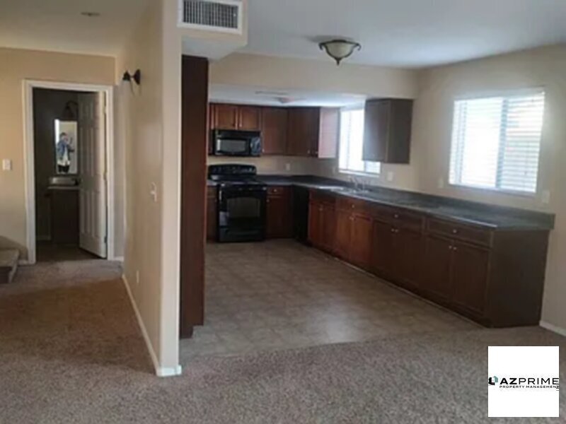
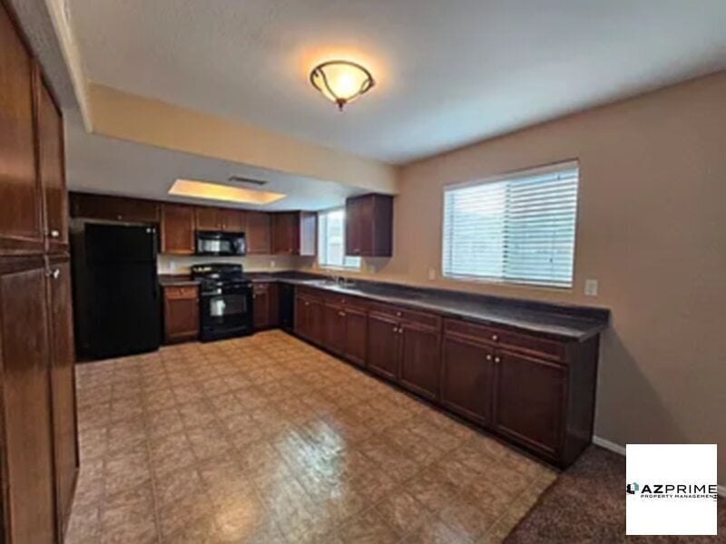
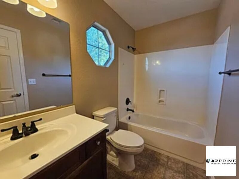
Charming 3-Bedroom, 3-Bathroom Home in Prime Chandler Location! Nestled in a quiet cul-de-sac, this two-story home offers 3 spacious bedrooms and 3 full bathroomsperfect for families or roommates. Located in a highly sought-after Chandler neighborhood, just off Alma School and Elliott, it provides easy access to shopping, dining, and top-rated schools. With a 2-car garage and a private backyard, this home is ideal for both comfort and convenience. Dont miss your chance to live in this desirable areaschedule a tour today!
3458 N Apache Ct is a house located in Maricopa County and the 85224 ZIP Code. This area is served by the Mesa Unified attendance zone.
* Price shown is base rent. Excludes user-selected optional fees and variable or usage-based fees and required charges due at or prior to move-in or at move-out. Price, availability, fees, and any applicable rent special are subject to change without notice.
* Square footage definitions vary. Displayed square footage is approximate.
Contact
- Listed by AZ Prime Property Management
- Phone Number
- Contact
Location
Get Directions
Fashionistas that live in the North Chandler area will appreciate the close proximity to Chandler Fashion Center. This mall has a varied selection of stores, which range from affordable to high-end. When it comes to groceries, residents have their choice of international supermarkets, or can opt for the organic Whole Foods Market.
If golf is your passion, then you’ll love tee time at San Marcos Golf Course. The neighborhood and surrounding area is encompassed with parks, including Arrowhead Meadows Park and Brooks Crossing Park – all great for outdoor recreational activities. The Perch Brewery is an excellent place for local craft beer as well as birdwatching. This North Chandler pub has more than forty beers on tap, and is the home of over fifty exotic rescue birds. Looking for something yummy to eat? Be sure to try Bella Gusto Urban Pizzeria, Elvira’s Belizean Café, Filiberto’s Mexican Food, Nishikawa Ramen, and Pho Viet Nam.
Learn more about living in North Chandler
Education
| Colleges & Universities | Distance | ||
|---|---|---|---|
| Colleges & Universities | Distance | ||
| Drive: | 7 min | 3.2 mi | |
| Drive: | 9 min | 3.6 mi | |
| Drive: | 13 min | 6.5 mi | |
| Drive: | 13 min | 6.7 mi |
3458 N Apache Ct is within 7 minutes or 3.2 miles from Alverno College. It is also near Mesa C.C., Southern and Dobson and Benedictine University.
Schools


Public Elementary School
Grades PK & 2
Nearby
Public Elementary & Middle School
Grades PK-8
1,227 Students
Attendance Zone
Public High School
Grades 9-12
2,370 Students
Attendance Zone
Private Elementary School
Grades PK-6
Nearby
Private Elementary & Middle School
Grades K-7
26 Students
Nearby
Private Elementary, Middle & High School
Grades 1-12
Nearby
Private Elementary, Middle & High School
Grades 4-11
Nearby
Private Middle & High School
Grades 8-12
Nearby
School data provided by
 The GreatSchools Rating helps parents compare schools within a state based on a variety of school quality indicators and provides a helpful picture of how effectively each school serves all of its students. Ratings are on a scale of 1 (below average) to 10 (above average) and can include test scores, college readiness, academic progress, advanced courses, equity, discipline and attendance data. We also advise parents to visit schools, consider other information on school performance and programs, and consider family needs as part of the school selection process.
View GreatSchools Rating Methodology
Data provided by GreatSchools.org © 2025. All rights reserved.
View GreatSchools Rating Methodology
Data provided by GreatSchools.org © 2025. All rights reserved.
Transportation options available in Chandler include Alma School/Main St, located 4.7 miles from 3458 N Apache Ct. 3458 N Apache Ct is near Phoenix-Mesa Gateway, located 14.5 miles or 27 minutes away, and Phoenix Sky Harbor International, located 15.0 miles or 23 minutes away.
| Transit / Subway | Distance | ||
|---|---|---|---|
| Transit / Subway | Distance | ||
|
|
Drive: | 9 min | 4.7 mi |
|
|
Drive: | 11 min | 5.5 mi |
|
|
Drive: | 10 min | 5.7 mi |
|
|
Drive: | 12 min | 6.2 mi |
|
|
Drive: | 11 min | 6.9 mi |
| Commuter Rail | Distance | ||
|---|---|---|---|
| Commuter Rail | Distance | ||
|
|
Drive: | 39 min | 28.4 mi |
| Airports | Distance | ||
|---|---|---|---|
| Airports | Distance | ||
|
Phoenix-Mesa Gateway
|
Drive: | 27 min | 14.5 mi |
|
Phoenix Sky Harbor International
|
Drive: | 23 min | 15.0 mi |
Time and distance from 3458 N Apache Ct.
| Shopping Centers | Distance | ||
|---|---|---|---|
| Shopping Centers | Distance | ||
| Walk: | 11 min | 0.6 mi | |
| Walk: | 12 min | 0.7 mi | |
| Walk: | 18 min | 1.0 mi |
3458 N Apache Ct has 3 shopping centers within 1.0 mile, which is about a 18-minute walk. The miles and minutes will be for the farthest away property.
| Parks and Recreation | Distance | ||
|---|---|---|---|
| Parks and Recreation | Distance | ||
|
i.d.e.a. Museum
|
Drive: | 11 min | 5.9 mi |
|
Arizona Museum of Natural History
|
Drive: | 12 min | 6.2 mi |
|
South Mountain Park
|
Drive: | 19 min | 8.1 mi |
|
ASU Center for Meteorite Studies
|
Drive: | 18 min | 10.0 mi |
|
Desert Arboretum Park
|
Drive: | 17 min | 10.1 mi |
3458 N Apache Ct has 5 parks within 10.1 miles, including i.d.e.a. Museum, Arizona Museum of Natural History, and South Mountain Park.
| Hospitals | Distance | ||
|---|---|---|---|
| Hospitals | Distance | ||
| Drive: | 5 min | 2.2 mi | |
| Drive: | 6 min | 3.1 mi | |
| Drive: | 8 min | 3.7 mi |
3458 N Apache Ct has 3 hospitals within 3.7 miles, the nearest is Oasis Behavioral Health Hospital which is 2.2 miles away and a 5 minute drive.
| Military Bases | Distance | ||
|---|---|---|---|
| Military Bases | Distance | ||
| Drive: | 23 min | 15.7 mi | |
| Drive: | 53 min | 40.2 mi | |
| Drive: | 108 min | 87.2 mi |
3458 N Apache Ct has 3 military bases within 87.2 miles, the nearest is Phoenix Sky Harbor Airport Air Guard Station which is 15.7 miles away and a 23 minute drive.
You May Also Like
Similar Rentals Nearby


What Are Walk Score®, Transit Score®, and Bike Score® Ratings?
Walk Score® measures the walkability of any address. Transit Score® measures access to public transit. Bike Score® measures the bikeability of any address.
What is a Sound Score Rating?
A Sound Score Rating aggregates noise caused by vehicle traffic, airplane traffic and local sources

3458 N Apache Ct
Chandler, AZ 85224