

$4,500
Total Monthly Price
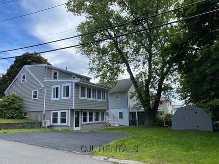
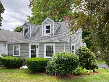
342 Forest St
Arlington, MA 02474
2 Weeks Ago
|
Edit
Favorites
342 Forest St

Favorites
Check Back Soon for Upcoming Availability
| Beds | Baths | Average SF |
|---|---|---|
| 3 Bedrooms 3 Bedrooms 3 Br | 2 Baths 2 Baths 2 Ba | — |
About This Property
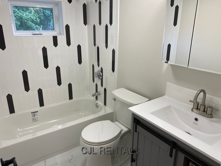
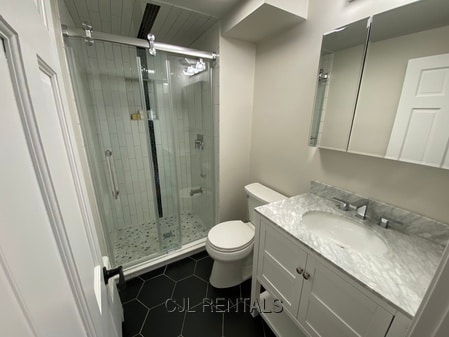
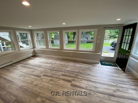
AVAILABLE JUNE 1st! WHAT A LOVELY HOME TO RENT! This completely renovated 3 bedroom/2 bathroom home is ready for you to just move in! Located on a very nice corner lot in the Turkey Hill/Arlington Heights neighborhood is also close to the Winchester line. Beautiful and spacious open-concept kitchen/dining area, formal living room with custom built-ins, 1 bedroom & 1 full bathroom round out the 1st floor. There are 2 bedrooms & 1 full bathroom on the 2nd floor. Downstairs has a walk-out basement with a large family room and a large sunroom with wall to wall windows overlooking the back yard. Mini split heat pump controls heat & provides A/C on the 1st floor, gas heat & window A/C's on the 2nd floor, washer & dryer, driveway parking and much more! EXCELLENT LOCATION - Great for commuters with bus stop directly to the Red Line at Alewife T Station and easy driving access to Routes 2, 3, 93, & 128. Nearby is Whole Foods, Trader Joe's, restaurants, museums & the Minuteman Bike Path. NO SMOKING! 1/2 MONTH RENTAL FEE. To schedule a viewing CALL/TEXT Cheryl @ or EMAIL
342 Forest St is a condo located in Middlesex County and the 02474 ZIP Code. This area is served by the Arlington Public Schools attendance zone.
342 Forest St,
Arlington,
MA
02474
Arlington Heights comprises one of three neighborhoods in Arlington and lies to the west of Arlington’s center. Located six miles northwest of Boston, this area is home to some historically significant sites and architecture and a more diverse housing market than the rest of Arlington.
A large number of famous residents, including actor Timothy Hutton, basketball player Tiny Archibald, and poet Robert Creeley have lived in Arlington Heights. Its dedication to preserving green space and natural areas has resulted in more than a dozen parks and historical sites in the town’s 5.5 square miles. Families love the area for its relative serenity and great schools, but all renters will find something they love thanks to single-family homes, mid and low-rise apartments, and a charming smattering of local restaurants and shops.
Learn more about living in Arlington HeightsBelow are rent ranges for similar nearby apartments
Education
| Colleges & Universities | Distance | ||
|---|---|---|---|
| Colleges & Universities | Distance | ||
| Drive: | 8 min | 4.6 mi | |
| Drive: | 11 min | 5.3 mi | |
| Drive: | 11 min | 5.7 mi | |
| Drive: | 12 min | 6.0 mi |
342 Forest St is within 8 minutes or 4.6 miles from Tufts Univ., Medford. It is also near Lesley University, Porter and Lesley University.
Schools


Public Elementary School
Grades PK-5
447 Students
Nearby
Public Elementary School
Grades K-5
423 Students
Attendance Zone
Public Elementary School
Grades K-5
327 Students
Attendance Zone
Public Middle School
Grades 6-8
977 Students
Attendance Zone
Public High School
Grades 9-12
1,757 Students
Attendance Zone
Private Elementary & Middle School
Grades K-8
Nearby
Private Elementary School
Grades PK-5
82 Students
Nearby
Private Middle & High School
Grades 6-12
281 Students
Nearby
School data provided by
 The GreatSchools Rating helps parents compare schools within a state based on a variety of school quality indicators and provides a helpful picture of how effectively each school serves all of its students. Ratings are on a scale of 1 (below average) to 10 (above average) and can include test scores, college readiness, academic progress, advanced courses, equity, discipline and attendance data. We also advise parents to visit schools, consider other information on school performance and programs, and consider family needs as part of the school selection process.
View GreatSchools Rating Methodology
Data provided by GreatSchools.org © 2026. All rights reserved.
View GreatSchools Rating Methodology
Data provided by GreatSchools.org © 2026. All rights reserved.
Transportation options available in Arlington include Davis Station, located 4.3 miles from 342 Forest St. 342 Forest St is near General Edward Lawrence Logan International, located 12.3 miles or 22 minutes away.
| Transit / Subway | Distance | ||
|---|---|---|---|
| Transit / Subway | Distance | ||
|
|
Drive: | 9 min | 4.3 mi |
| Drive: | 7 min | 4.4 mi | |
| Drive: | 8 min | 4.4 mi | |
| Drive: | 10 min | 5.0 mi | |
|
|
Drive: | 10 min | 5.1 mi |
| Commuter Rail | Distance | ||
|---|---|---|---|
| Commuter Rail | Distance | ||
|
|
Drive: | 5 min | 2.5 mi |
|
|
Drive: | 4 min | 2.6 mi |
|
|
Drive: | 6 min | 3.3 mi |
|
|
Drive: | 6 min | 3.4 mi |
|
|
Drive: | 8 min | 4.3 mi |
| Airports | Distance | ||
|---|---|---|---|
| Airports | Distance | ||
|
General Edward Lawrence Logan International
|
Drive: | 22 min | 12.3 mi |
Walkability Near 342 Forest St Arlington, MA 02474
Getting Around
 What do Walkability, Transit, Drivability, and Bikeability mean?
Walkability measures the walking distance to day-to-day needs.
Transit measures access to public transportation.
Drivability measures congestion, parking availability, and access to major roads.
Bikeability measures the suitability for cycling.
How It Works
What do Walkability, Transit, Drivability, and Bikeability mean?
Walkability measures the walking distance to day-to-day needs.
Transit measures access to public transportation.
Drivability measures congestion, parking availability, and access to major roads.
Bikeability measures the suitability for cycling.
How It Works
Fairly Walkable
Walkability
50
/ 100
Limited Public Transit
Transit
30
/ 100
Exceptionally Drivable
Drivability
100
/ 100
Moderately Bikeable
Bikeability
60
/ 100
Scores provided by
-
Soundscore™
-
/ 100
Traffic
-Airport
-Businesses
-Scores provided by
HowLoud What is a Sound Score Rating? A Sound Score Rating aggregates noise caused by vehicle traffic, airplane traffic and local sources. How It WorksTime and distance from 342 Forest St.
| Shopping Centers | Distance | ||
|---|---|---|---|
| Shopping Centers | Distance | ||
| Drive: | 2 min | 1.2 mi | |
| Drive: | 5 min | 2.9 mi | |
| Drive: | 8 min | 4.2 mi |
342 Forest St has 3 shopping centers within 4.2 miles, which is about a 8-minute drive. The miles and minutes will be for the farthest away property.
| Parks and Recreation | Distance | ||
|---|---|---|---|
| Parks and Recreation | Distance | ||
|
Mass Audubon's Habitat Education Center and Wildlife Sanctuary
|
Drive: | 7 min | 3.0 mi |
|
Beaver Brook Reservation
|
Drive: | 9 min | 4.7 mi |
|
Harvard-Smithsonian Center for Astrophysics
|
Drive: | 11 min | 6.0 mi |
|
Walter D. Stone Memorial Zoo
|
Drive: | 13 min | 6.2 mi |
|
Middlesex Fells Reservation
|
Drive: | 13 min | 7.8 mi |
342 Forest St has 5 parks within 7.8 miles, including Mass Audubon's Habitat Education Center and Wildlife Sanctuary, Beaver Brook Reservation, and Harvard-Smithsonian Center for Astrophysics.
| Hospitals | Distance | ||
|---|---|---|---|
| Hospitals | Distance | ||
| Drive: | 8 min | 4.0 mi | |
| Drive: | 8 min | 4.0 mi | |
| Drive: | 10 min | 4.9 mi |
342 Forest St has 3 hospitals within 4.9 miles, the nearest is Winchester Hospital which is 4.0 miles away and a 8 minute drive.
| Military Bases | Distance | ||
|---|---|---|---|
| Military Bases | Distance | ||
| Drive: | 15 min | 7.3 mi | |
| Drive: | 32 min | 18.2 mi |
342 Forest St is 7.3 miles from Hanscom Air Force Base, and is convenient to other military bases, including US Military Reservation.
You May Also Like
Similar Rentals Nearby


What Are Walk Score®, Transit Score®, and Bike Score® Ratings?
Walk Score® measures the walkability of any address. Transit Score® measures access to public transit. Bike Score® measures the bikeability of any address.
What is a Sound Score Rating?
A Sound Score Rating aggregates noise caused by vehicle traffic, airplane traffic and local sources.
342 Forest St
Arlington, MA 02474