
Hue39
3909 San Fernando Rd,
Glendale, CA 91204
$2,695 - $2,800
1-2 Beds


Located on a quiet street in prime Glendale. Featuring two 2bed/2bath with its own water heater in each unit. All units include hardwood floors, refrigerator, range and oven. Community laundry room is located in the the building, along with a small side yard.
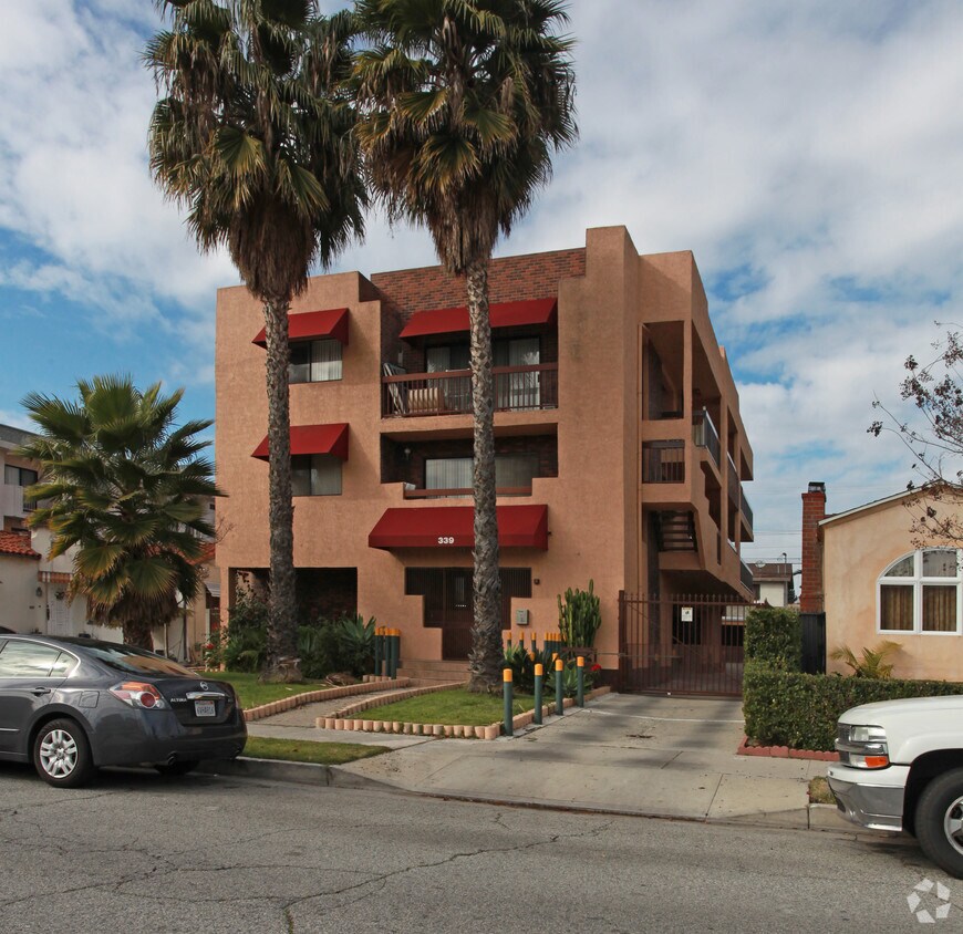
339 Irving Ave is an apartment community located in Los Angeles County and the 91201 ZIP Code. This area is served by the Glendale Unified School District attendance zone.
Air Conditioning
Dishwasher
Hardwood Floors
Yard
Between the Verdugo Mountains and Los Angeles, Glendale combines suburban living with metropolitan convenience. The city offers various housing options, from apartments in downtown near the Americana at Brand to established residential areas like Adams Hill and Verdugo Woodlands. Current rental prices range from $2,045 for studios to $4,344 for four-bedroom units, with annual increases between 1.9% and 3%. Brand Park offers hiking trails and houses the Brand Library, while the historic Alex Theatre continues its tradition of entertainment and cultural programming.
Glendale's location provides easy access to major employment centers, including DreamWorks Animation and Walt Disney Imagineering. The Glendale Galleria and Americana at Brand serve as premier shopping destinations, while the city's dining scene features numerous restaurants specializing in Armenian and international cuisine. Residents appreciate the city's parks system, public services, and transportation options.
Learn more about living in GlendaleCompare neighborhood and city base rent averages by bedroom.
| Riverside Rancho | Glendale, CA | |
|---|---|---|
| Studio | $1,751 | $2,026 |
| 1 Bedroom | $1,461 | $2,124 |
| 2 Bedrooms | $1,960 | $2,677 |
| 3 Bedrooms | $2,793 | $3,452 |
| Colleges & Universities | Distance | ||
|---|---|---|---|
| Colleges & Universities | Distance | ||
| Drive: | 5 min | 2.4 mi | |
| Drive: | 9 min | 4.4 mi | |
| Drive: | 8 min | 5.1 mi | |
| Drive: | 13 min | 7.2 mi |


Transportation options available in Glendale include Universal City/Studio City, located 5.8 miles from 339 Irving Ave. 339 Irving Ave is near Bob Hope, located 6.5 miles or 12 minutes away, and Los Angeles International, located 24.8 miles or 38 minutes away.
| Transit / Subway | Distance | ||
|---|---|---|---|
| Transit / Subway | Distance | ||
|
|
Drive: | 9 min | 5.8 mi |
|
|
Drive: | 10 min | 6.3 mi |
|
|
Drive: | 9 min | 6.3 mi |
|
|
Drive: | 11 min | 6.8 mi |
|
|
Drive: | 13 min | 6.9 mi |
| Commuter Rail | Distance | ||
|---|---|---|---|
| Commuter Rail | Distance | ||
|
|
Drive: | 4 min | 1.5 mi |
|
|
Drive: | 8 min | 4.2 mi |
| Drive: | 7 min | 4.2 mi | |
|
|
Drive: | 8 min | 4.8 mi |
|
|
Drive: | 10 min | 6.6 mi |
| Airports | Distance | ||
|---|---|---|---|
| Airports | Distance | ||
|
Bob Hope
|
Drive: | 12 min | 6.5 mi |
|
Los Angeles International
|
Drive: | 38 min | 24.8 mi |
Scores provided by
Traffic
-Airport
-Businesses
-Scores provided by
HowLoud What is a Sound Score Rating? A Sound Score Rating aggregates noise caused by vehicle traffic, airplane traffic and local sources. How It WorksTime and distance from 339 Irving Ave.
| Shopping Centers | Distance | ||
|---|---|---|---|
| Shopping Centers | Distance | ||
| Walk: | 6 min | 0.3 mi | |
| Walk: | 14 min | 0.7 mi | |
| Walk: | 17 min | 0.9 mi |
| Parks and Recreation | Distance | ||
|---|---|---|---|
| Parks and Recreation | Distance | ||
|
Los Angeles Zoo
|
Drive: | 12 min | 3.6 mi |
|
Bird Sanctuary
|
Drive: | 11 min | 5.8 mi |
|
Griffith Observatory
|
Drive: | 15 min | 7.0 mi |
|
Griffith Park
|
Drive: | 24 min | 9.2 mi |
|
La Tuna Canyon Park
|
Drive: | 16 min | 10.4 mi |
| Hospitals | Distance | ||
|---|---|---|---|
| Hospitals | Distance | ||
| Drive: | 4 min | 1.8 mi | |
| Drive: | 7 min | 4.5 mi | |
| Drive: | 9 min | 5.4 mi |
| Military Bases | Distance | ||
|---|---|---|---|
| Military Bases | Distance | ||
| Drive: | 35 min | 26.4 mi | |
| Drive: | 47 min | 34.2 mi | |
| Drive: | 49 min | 37.2 mi |
Pets Allowed Fitness Center Pool Maintenance on site High-Speed Internet Controlled Access EV Charging
What Are Walk Score®, Transit Score®, and Bike Score® Ratings?
Walk Score® measures the walkability of any address. Transit Score® measures access to public transit. Bike Score® measures the bikeability of any address.
What is a Sound Score Rating?
A Sound Score Rating aggregates noise caused by vehicle traffic, airplane traffic and local sources.
339 Irving Ave
Glendale, CA 91201


