

$4,995
/ Month
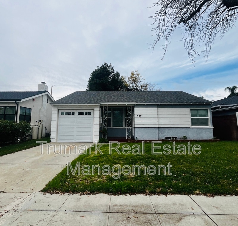
337 S Beachwood Dr
Burbank, CA 91506
Today
|
Edit
Favorites
747-307-6165
-
Bedrooms
3
-
Bathrooms
2
-
Square Feet
2,400 sq ft
-
Available
Available Now
337 S Beachwood Dr

Favorites
About This Home
$4,995 deposit,
Available Now
This is only a waitlist! Text Michele 8 1 8 - 4 0 2 - 0 8 2 3 with any questions!
337 S Beachwood Dr is a house located in Los Angeles County and the 91506 ZIP Code. This area is served by the Burbank Unified attendance zone.
* Price shown is base rent. Excludes user-selected optional fees and variable or usage-based fees and required charges due at or prior to move-in or at move-out. Price, availability, fees, and any applicable rent special are subject to change without notice.
* Square footage definitions vary. Displayed square footage is approximate.
Fees and Policies
The fees below are based on community-supplied data and may exclude additional fees and utilities.
-
One-Time Basics
-
Due at Move-In
-
Security Deposit - RefundableCharged per unit.$4,995
-
-
Due at Move-In
-
Dogs
-
Allowed
-
-
Cats
-
Allowed
-
Property Fee Disclaimer: Based on community-supplied data and independent market research. Subject to change without notice. May exclude fees for mandatory or optional services and usage-based utilities.
House Features
- Dishwasher
- Patio
Contact
- Phone Number
- Contact
Location
Get Directions
Amenities
- Dishwasher
- Patio
Rancho Adjacent, near the center of Burbank, combines a mixture of single-family homes, apartments, small and large commercial areas, industrial zones, and city government buildings. Residents enjoy the convenience of having a variety goods and services within a short drive. Rancho Adjacent borders the horse-oriented neighborhood known as Rancho just south of the community.
Bordered by Verdugo and Alameda Avenues, Rancho Adjacent stretches from Hollywood Way across Interstate 5 to Glenoaks Boulevard. Olive Avenue cuts diagonally through the neighborhood and is lined with restaurants and small businesses. Rancho Adjacent also lies just north of the Ventura Freeway, a major east-west link across the San Fernando Valley. Downtown Los Angeles rests 13 miles south of Rancho Adjacent, making this compact community a great choice no matter where your commute takes you.
Learn more about living in Rancho Adjacent
Education
| Colleges & Universities | Distance | ||
|---|---|---|---|
| Colleges & Universities | Distance | ||
| Drive: | 4 min | 1.7 mi | |
| Drive: | 8 min | 3.9 mi | |
| Drive: | 11 min | 5.6 mi | |
| Drive: | 11 min | 6.2 mi |
337 S Beachwood Dr is within 4 minutes or 1.7 miles from New York Film Academy. It is also near Woodbury University and Musicians Institute.
Schools


Public Elementary School
Grades K-5
452 Students
Attendance Zone
Charter Elementary School
Grades K-5
75 Students
Nearby
Public Middle School
Grades 6-8
950 Students
Attendance Zone
Public High School
Grades 9-12
2,305 Students
Attendance Zone
Private Elementary & Middle School
Grades PK-8
283 Students
Nearby
Private Elementary School
Grades PK-1
Nearby
Private Middle & High School
Grades 6-12
Nearby
School data provided by
 The GreatSchools Rating helps parents compare schools within a state based on a variety of school quality indicators and provides a helpful picture of how effectively each school serves all of its students. Ratings are on a scale of 1 (below average) to 10 (above average) and can include test scores, college readiness, academic progress, advanced courses, equity, discipline and attendance data. We also advise parents to visit schools, consider other information on school performance and programs, and consider family needs as part of the school selection process.
View GreatSchools Rating Methodology
Data provided by GreatSchools.org © 2026. All rights reserved.
View GreatSchools Rating Methodology
Data provided by GreatSchools.org © 2026. All rights reserved.
Transportation options available in Burbank include Universal City/Studio City, located 3.8 miles from 337 S Beachwood Dr. 337 S Beachwood Dr is near Bob Hope, located 6.1 miles or 11 minutes away, and Los Angeles International, located 18.9 miles or 37 minutes away.
| Transit / Subway | Distance | ||
|---|---|---|---|
| Transit / Subway | Distance | ||
|
|
Drive: | 7 min | 3.8 mi |
|
|
Drive: | 7 min | 4.3 mi |
|
|
Drive: | 10 min | 5.5 mi |
|
|
Drive: | 10 min | 5.9 mi |
|
|
Drive: | 11 min | 6.7 mi |
| Commuter Rail | Distance | ||
|---|---|---|---|
| Commuter Rail | Distance | ||
|
|
Drive: | 3 min | 1.3 mi |
|
|
Drive: | 8 min | 3.8 mi |
| Drive: | 7 min | 3.9 mi | |
|
|
Drive: | 9 min | 5.6 mi |
|
|
Drive: | 10 min | 6.2 mi |
| Airports | Distance | ||
|---|---|---|---|
| Airports | Distance | ||
|
Bob Hope
|
Drive: | 11 min | 6.1 mi |
|
Los Angeles International
|
Drive: | 37 min | 18.9 mi |
Time and distance from 337 S Beachwood Dr.
| Shopping Centers | Distance | ||
|---|---|---|---|
| Shopping Centers | Distance | ||
| Walk: | 7 min | 0.4 mi | |
| Walk: | 8 min | 0.4 mi | |
| Walk: | 12 min | 0.6 mi |
337 S Beachwood Dr has 3 shopping centers within 0.6 mile, which is about a 12-minute walk. The miles and minutes will be for the farthest away property.
| Parks and Recreation | Distance | ||
|---|---|---|---|
| Parks and Recreation | Distance | ||
|
Los Angeles Zoo
|
Drive: | 14 min | 4.6 mi |
|
Runyon Canyon
|
Drive: | 12 min | 6.0 mi |
|
Bird Sanctuary
|
Drive: | 13 min | 7.2 mi |
|
Griffith Observatory
|
Drive: | 17 min | 8.4 mi |
|
Griffith Park
|
Drive: | 26 min | 10.6 mi |
337 S Beachwood Dr has 5 parks within 10.6 miles, including Los Angeles Zoo, Griffith Park, and Griffith Observatory.
| Hospitals | Distance | ||
|---|---|---|---|
| Hospitals | Distance | ||
| Walk: | 16 min | 0.8 mi | |
| Drive: | 9 min | 5.9 mi | |
| Drive: | 11 min | 6.3 mi |
337 S Beachwood Dr has 3 hospitals within 6.3 miles, the nearest is Providence Saint Joseph Medical Center which is 0.8 mile away and a 16 minute walk.
| Military Bases | Distance | ||
|---|---|---|---|
| Military Bases | Distance | ||
| Drive: | 37 min | 20.5 mi |
337 S Beachwood Dr is 20.5 miles and a 37 minute drive from Los Angeles Air Force Base.
You May Also Like
Similar Rentals Nearby


What Are Walk Score®, Transit Score®, and Bike Score® Ratings?
Walk Score® measures the walkability of any address. Transit Score® measures access to public transit. Bike Score® measures the bikeability of any address.
What is a Sound Score Rating?
A Sound Score Rating aggregates noise caused by vehicle traffic, airplane traffic and local sources
337 S Beachwood Dr
Burbank, CA 91506