

$4,000
/ Month
330 S Sparks St
Burbank, CA 91506
1 Day Ago
Favorites
818-473-4516
-
Bedrooms
2
-
Bathrooms
1.5
-
Square Feet
983 sq ft
-
Available
Available Now
330 S Sparks St

Favorites
About This Home
$4,000 deposit,
Available Now
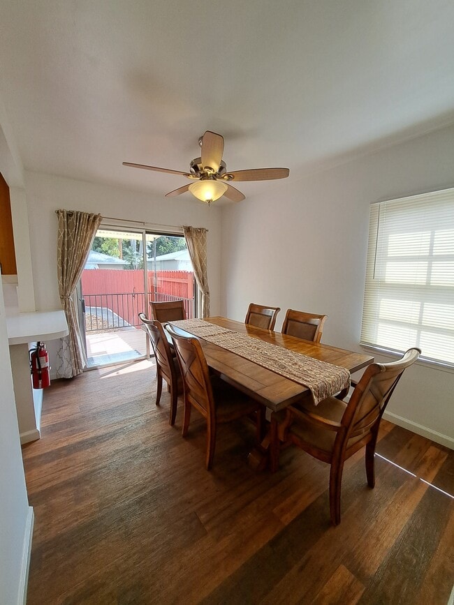
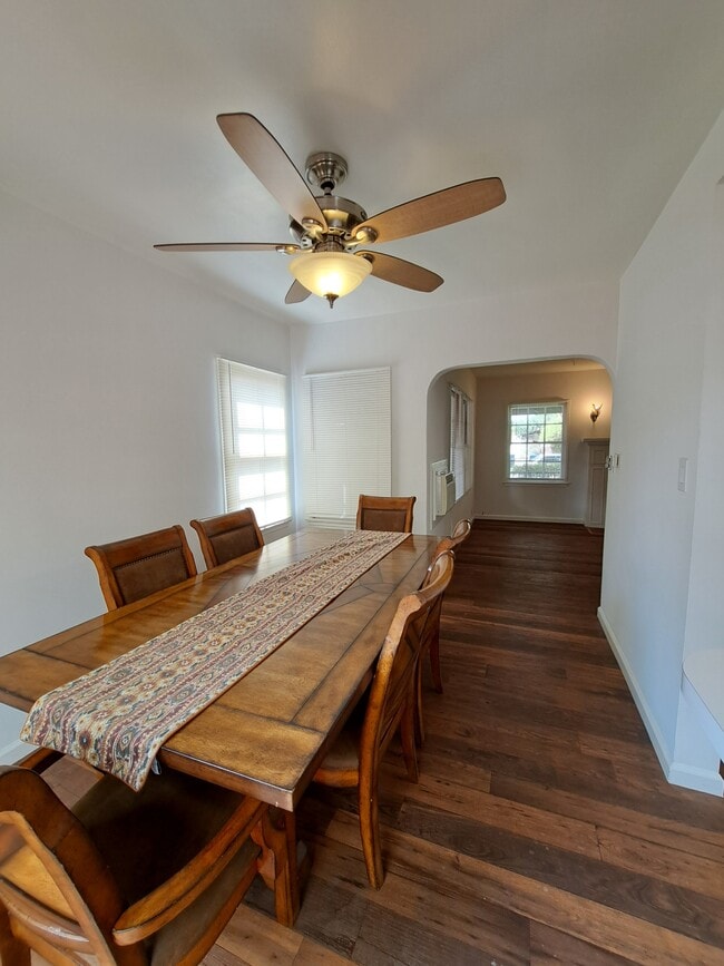
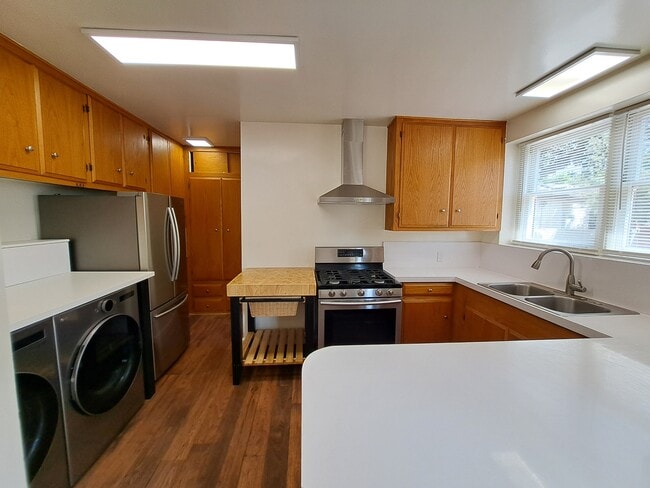
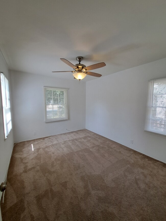
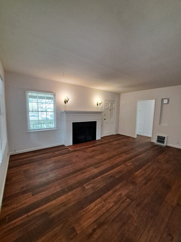
Located between Magnolia Park and the Burbank Rancho, this charming 2-bedroom, 1.5-bath home offers comfort, convenience, and character in a sought-after neighborhood. Interior Features: • Living room with gas log fireplace framed by beautiful stained-glass butterfly sconces • Vinyl plank flooring in living areas, carpet in bedrooms • Fresh paint & mini blinds throughout • Spacious kitchen with stainless steel appliances (refrigerator, stove, vent hood, washer & dryer) • Dining nook with sliding glass door to deck • Primary bedroom with half bath, window A/C, and backyard access • Hall bath with newer vanity, tub, and separate shower • Extra hallway storage, wall A/C in living room, and floor heater Outdoor Features: • Large backyard with new wood fence for privacy • Mature shade tree in front yard • Covered front porch for relaxing & greeting neighbors • Driveway parking included • Yard care included Location Highlights: • Minutes from Warner Bros. & Disney Studios • Close to Griffith Park & Burbank Equestrian Center • Near Magnolia Park shops & restaurants • Easy freeway access Please note: This home is on a shared lot with an additional unit. Utilities are shared and billed back monthly. This is a non-smoking unit. Tenants must have excellent credit to qualify (FICO score of 700 or above), combined household verifiable monthly income must be at least 3 times the rent, pets okay with additional deposit. Tenants to carry and maintain renter's insurance during tenancy. Please call today to schedule a showing. Must view property with the property manager before applying.
330 S Sparks St is a house located in Los Angeles County and the 91506 ZIP Code. This area is served by the Burbank Unified attendance zone.
* Price shown is base rent. Excludes user-selected optional fees and variable or usage-based fees and required charges due at or prior to move-in or at move-out. Price, availability, fees, and any applicable rent special are subject to change without notice.
* Square footage definitions vary. Displayed square footage is approximate.
Contact
- Listed by Natalie Wolfe
- Phone Number
- Contact
Location
Get Directions
Rancho Adjacent, near the center of Burbank, combines a mixture of single-family homes, apartments, small and large commercial areas, industrial zones, and city government buildings. Residents enjoy the convenience of having a variety goods and services within a short drive. Rancho Adjacent borders the horse-oriented neighborhood known as Rancho just south of the community.
Bordered by Verdugo and Alameda Avenues, Rancho Adjacent stretches from Hollywood Way across Interstate 5 to Glenoaks Boulevard. Olive Avenue cuts diagonally through the neighborhood and is lined with restaurants and small businesses. Rancho Adjacent also lies just north of the Ventura Freeway, a major east-west link across the San Fernando Valley. Downtown Los Angeles rests 13 miles south of Rancho Adjacent, making this compact community a great choice no matter where your commute takes you.
Learn more about living in Rancho Adjacent
Education
| Colleges & Universities | Distance | ||
|---|---|---|---|
| Colleges & Universities | Distance | ||
| Drive: | 3 min | 1.7 mi | |
| Drive: | 8 min | 3.9 mi | |
| Drive: | 11 min | 5.5 mi | |
| Drive: | 11 min | 6.2 mi |
330 S Sparks St is within 3 minutes or 1.7 miles from New York Film Academy. It is also near Woodbury University and Musicians Institute.
Schools


Public Elementary School
Grades K-5
452 Students
Attendance Zone
Charter Elementary School
Grades K-5
75 Students
Nearby
Public Middle School
Grades 6-8
950 Students
Attendance Zone
Public High School
Grades 9-12
2,305 Students
Attendance Zone
Private Elementary & Middle School
Grades PK-8
283 Students
Nearby
Private Elementary School
Grades PK-1
Nearby
Private Middle & High School
Grades 6-12
Nearby
School data provided by
 The GreatSchools Rating helps parents compare schools within a state based on a variety of school quality indicators and provides a helpful picture of how effectively each school serves all of its students. Ratings are on a scale of 1 (below average) to 10 (above average) and can include test scores, college readiness, academic progress, advanced courses, equity, discipline and attendance data. We also advise parents to visit schools, consider other information on school performance and programs, and consider family needs as part of the school selection process.
View GreatSchools Rating Methodology
Data provided by GreatSchools.org © 2025. All rights reserved.
View GreatSchools Rating Methodology
Data provided by GreatSchools.org © 2025. All rights reserved.
Transportation options available in Burbank include Universal City/Studio City, located 3.8 miles from 330 S Sparks St. 330 S Sparks St is near Bob Hope, located 6.1 miles or 11 minutes away, and Los Angeles International, located 18.8 miles or 37 minutes away.
| Transit / Subway | Distance | ||
|---|---|---|---|
| Transit / Subway | Distance | ||
|
|
Drive: | 7 min | 3.8 mi |
|
|
Drive: | 7 min | 4.2 mi |
|
|
Drive: | 10 min | 5.4 mi |
|
|
Drive: | 10 min | 5.9 mi |
|
|
Drive: | 11 min | 6.7 mi |
| Commuter Rail | Distance | ||
|---|---|---|---|
| Commuter Rail | Distance | ||
|
|
Drive: | 3 min | 1.3 mi |
|
|
Drive: | 8 min | 3.8 mi |
| Drive: | 7 min | 3.9 mi | |
|
|
Drive: | 9 min | 5.6 mi |
|
|
Drive: | 10 min | 6.2 mi |
| Airports | Distance | ||
|---|---|---|---|
| Airports | Distance | ||
|
Bob Hope
|
Drive: | 11 min | 6.1 mi |
|
Los Angeles International
|
Drive: | 37 min | 18.8 mi |
Time and distance from 330 S Sparks St.
| Shopping Centers | Distance | ||
|---|---|---|---|
| Shopping Centers | Distance | ||
| Walk: | 7 min | 0.4 mi | |
| Walk: | 8 min | 0.4 mi | |
| Walk: | 13 min | 0.7 mi |
330 S Sparks St has 3 shopping centers within 0.7 mile, which is about a 13-minute walk. The miles and minutes will be for the farthest away property.
| Parks and Recreation | Distance | ||
|---|---|---|---|
| Parks and Recreation | Distance | ||
|
Los Angeles Zoo
|
Drive: | 14 min | 4.6 mi |
|
Runyon Canyon
|
Drive: | 12 min | 5.9 mi |
|
Bird Sanctuary
|
Drive: | 13 min | 7.2 mi |
|
Griffith Observatory
|
Drive: | 17 min | 8.4 mi |
|
Griffith Park
|
Drive: | 26 min | 10.6 mi |
330 S Sparks St has 5 parks within 10.6 miles, including Los Angeles Zoo, Griffith Park, and Griffith Observatory.
| Hospitals | Distance | ||
|---|---|---|---|
| Hospitals | Distance | ||
| Walk: | 15 min | 0.8 mi | |
| Drive: | 9 min | 5.9 mi | |
| Drive: | 11 min | 6.3 mi |
330 S Sparks St has 3 hospitals within 6.3 miles, the nearest is Providence Saint Joseph Medical Center which is 0.8 mile away and a 15 minute walk.
| Military Bases | Distance | ||
|---|---|---|---|
| Military Bases | Distance | ||
| Drive: | 37 min | 20.5 mi |
330 S Sparks St is 20.5 miles and a 37 minute drive from Los Angeles Air Force Base.
You May Also Like
Similar Rentals Nearby


What Are Walk Score®, Transit Score®, and Bike Score® Ratings?
Walk Score® measures the walkability of any address. Transit Score® measures access to public transit. Bike Score® measures the bikeability of any address.
What is a Sound Score Rating?
A Sound Score Rating aggregates noise caused by vehicle traffic, airplane traffic and local sources
330 S Sparks St
Burbank, CA 91506