$4,200
Total Monthly Price
33 Thornton St Unit 2
Boston, MA 02119
2 Weeks Ago
Favorites
-
Bedrooms
3
-
Bathrooms
1
-
Square Feet
1,000 sq ft
-
Available
Available Sep 1
Highlights
- Pets Allowed
- Hardwood Floors
33 Thornton St Unit 2

Favorites
About This Home
12 Month Lease,
$4,200 deposit,
Available Sep 1
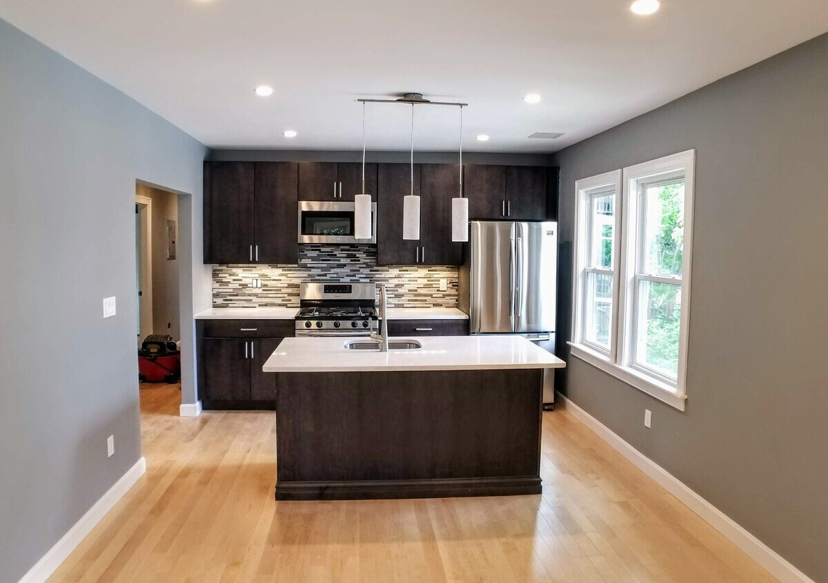
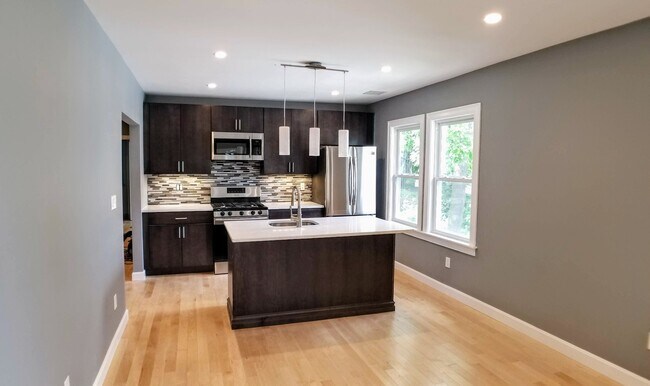
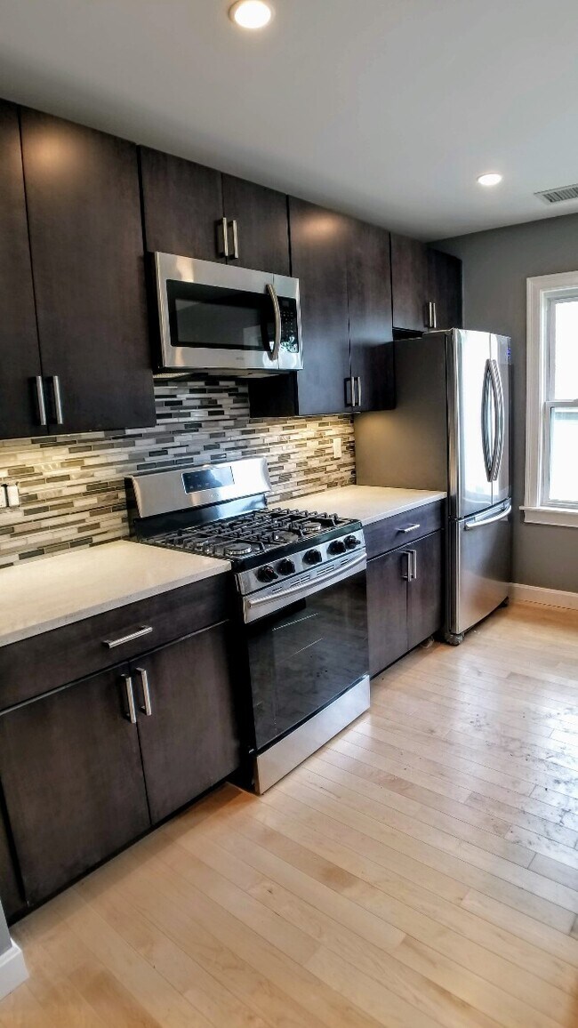
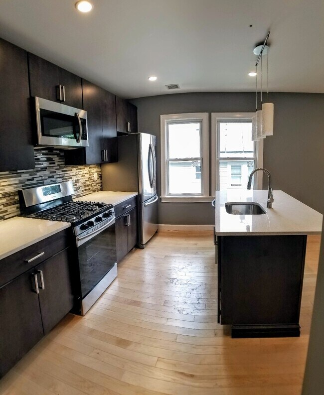
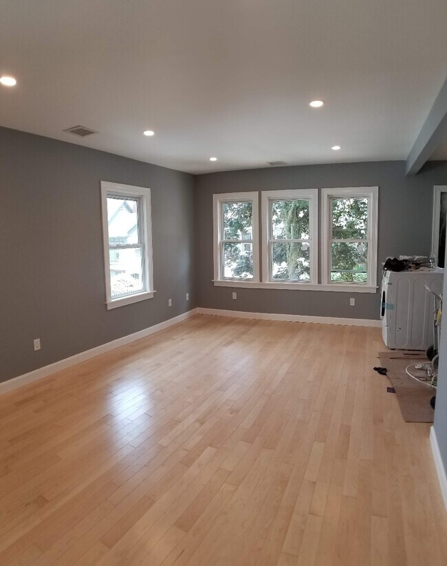
Spacious and updated 3 bed, 1 bath apartment in Fort Hill with 1,000 sq ft of living space. Features include hardwood floors, high ceilings, in-unit washer/dryer, and a full modern kitchen with stainless steel appliances. Outdoor parking available for rent. Located near Jackson Square and Roxbury Crossing Orange Line stops with easy access to Northeastern, Longwood Medical Area, and other major schools and hospitals. Pets negotiable and students are welcome. Move in costs are first month, last month, security deposit, and broker's fee. Serious inquiries only.
33 Thornton St is a condo located in Suffolk County and the 02119 ZIP Code. This area is served by the Boston Public Schools attendance zone.
* Price shown is total price including community-supplied monthly required fees. Price, availability, fees, and any applicable rent special are subject to change without notice.
* Square footage definitions vary. Displayed square footage is approximate.
Condo Features
Washer/Dryer
Air Conditioning
Dishwasher
Hardwood Floors
- Washer/Dryer
- Air Conditioning
- Dishwasher
- Stainless Steel Appliances
- Kitchen
- Hardwood Floors
- High Ceilings
Fees and Policies
The fees below are based on community-supplied data and may exclude additional fees and utilities.
- Dogs Allowed
-
Fees not specified
- Cats Allowed
-
Fees not specified
- Parking
-
Surface Lot--
Contact
- Contact
Location
Get Directions
Twenty minutes southwest of downtown Boston sits Highland Park, a primarily- residential neighborhood full of beautiful historic homes and apartments along tree-lined streets. The community features over a dozen parks and public green spaces, giving all residents easy access to trails, playgrounds, and historic sites wherever they may live.
The local dining scene is quite unique, with several African and Middle Eastern restaurants and cafes around the neighborhood. MBTA rail service on the west side of the neighborhood makes it easy for folks to get around the city for or leisure.
Learn more about living in Highland Park
Education
| Colleges & Universities | Distance | ||
|---|---|---|---|
| Colleges & Universities | Distance | ||
| Walk: | 21 min | 1.1 mi | |
| Drive: | 3 min | 1.5 mi | |
| Drive: | 4 min | 1.6 mi | |
| Drive: | 5 min | 2.1 mi |
33 Thornton St Unit 2 is within 21 minutes or 1.1 miles from Wentworth Inst. of Technology. It is also near MCPHS University, Boston and MassArt.
Schools


Public Elementary & Middle School
Grades 3-8
177 Students
Attendance Zone
Public Elementary School
Grades PK-6
169 Students
Attendance Zone
Public Middle & High School
Grades 7-12
1,567 Students
Attendance Zone
Public Middle School
Grades 6-8
205 Students
Attendance Zone
Charter High School
Grades 9-10 & 12
321 Students
Attendance Zone
Public High School
Grades 9-12
1,087 Students
Attendance Zone
Private Elementary, Middle & High School
Grades 1-10
Nearby
Private Elementary & Middle School
Grades 5-8
Nearby
Private Elementary School
Grades PK-6
Nearby
Private Middle & High School
Grades 6-12
67 Students
Nearby
School data provided by
 The GreatSchools Rating helps parents compare schools within a state based on a variety of school quality indicators and provides a helpful picture of how effectively each school serves all of its students. Ratings are on a scale of 1 (below average) to 10 (above average) and can include test scores, college readiness, academic progress, advanced courses, equity, discipline and attendance data. We also advise parents to visit schools, consider other information on school performance and programs, and consider family needs as part of the school selection process.
View GreatSchools Rating Methodology
Data provided by GreatSchools.org © 2025. All rights reserved.
View GreatSchools Rating Methodology
Data provided by GreatSchools.org © 2025. All rights reserved.
Transportation options available in Boston include Roxbury Crossing Station, located 0.6 mile from 33 Thornton St Unit 2. 33 Thornton St Unit 2 is near General Edward Lawrence Logan International, located 6.3 miles or 13 minutes away.
| Transit / Subway | Distance | ||
|---|---|---|---|
| Transit / Subway | Distance | ||
|
|
Walk: | 12 min | 0.6 mi |
|
|
Walk: | 15 min | 0.8 mi |
|
|
Drive: | 3 min | 1.3 mi |
|
|
Drive: | 4 min | 1.4 mi |
|
|
Drive: | 4 min | 1.8 mi |
| Commuter Rail | Distance | ||
|---|---|---|---|
| Commuter Rail | Distance | ||
|
|
Drive: | 4 min | 1.7 mi |
| Drive: | 4 min | 1.7 mi | |
|
|
Drive: | 4 min | 1.8 mi |
| Drive: | 6 min | 2.5 mi | |
|
|
Drive: | 11 min | 5.5 mi |
| Airports | Distance | ||
|---|---|---|---|
| Airports | Distance | ||
|
General Edward Lawrence Logan International
|
Drive: | 13 min | 6.3 mi |
Time and distance from 33 Thornton St Unit 2.
| Shopping Centers | Distance | ||
|---|---|---|---|
| Shopping Centers | Distance | ||
| Walk: | 15 min | 0.8 mi | |
| Drive: | 4 min | 1.7 mi | |
| Drive: | 4 min | 2.0 mi |
33 Thornton St Unit 2 has 3 shopping centers within 2.0 miles, which is about a 4-minute walk. The miles and minutes will be for the farthest away property.
| Parks and Recreation | Distance | ||
|---|---|---|---|
| Parks and Recreation | Distance | ||
|
Roxbury Heritage State Park
|
Walk: | 9 min | 0.5 mi |
|
Lower Neponset River Trail
|
Drive: | 4 min | 2.1 mi |
|
Franklin Park Zoo
|
Drive: | 5 min | 2.4 mi |
|
Charles River Reservation
|
Drive: | 6 min | 2.8 mi |
|
Coit Observatory
|
Drive: | 7 min | 3.2 mi |
33 Thornton St Unit 2 has 5 parks within 3.2 miles, including Roxbury Heritage State Park, Lower Neponset River Trail, and Franklin Park Zoo.
| Hospitals | Distance | ||
|---|---|---|---|
| Hospitals | Distance | ||
| Drive: | 4 min | 1.3 mi | |
| Drive: | 4 min | 1.4 mi | |
| Drive: | 3 min | 1.4 mi |
33 Thornton St Unit 2 has 3 hospitals within 1.4 miles, the nearest is New England Baptist Hospital which is 1.3 miles away and a 4 minute drive.
| Military Bases | Distance | ||
|---|---|---|---|
| Military Bases | Distance | ||
| Drive: | 30 min | 15.8 mi | |
| Drive: | 33 min | 16.3 mi |
33 Thornton St Unit 2 is 15.8 miles from US Military Reservation, and is convenient to other military bases, including Hanscom Air Force Base.
Amenities
- Washer/Dryer
- Air Conditioning
- Dishwasher
- Stainless Steel Appliances
- Kitchen
- Hardwood Floors
- High Ceilings
33 Thornton St Unit 2 Photos
What Are Walk Score®, Transit Score®, and Bike Score® Ratings?
Walk Score® measures the walkability of any address. Transit Score® measures access to public transit. Bike Score® measures the bikeability of any address.
What is a Sound Score Rating?
A Sound Score Rating aggregates noise caused by vehicle traffic, airplane traffic and local sources

33 Thornton St
Boston, MA 02119