

$3,000
Total Monthly Price
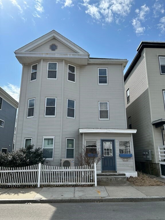
33 Rosemary St Unit 2
Boston, MA 02130
Favorites
33 Rosemary St Unit 2

Favorites
Check Back Soon for Upcoming Availability
| Beds | Baths | Average SF |
|---|---|---|
| 2 Bedrooms 2 Bedrooms 2 Br | 1 Bath 1 Bath 1 Ba | 1,300 SF |
About This Property
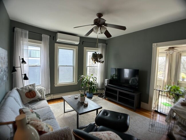
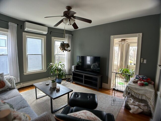
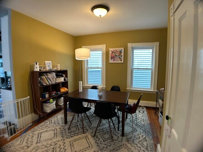
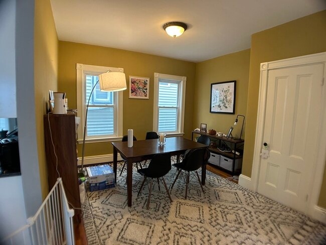
Exceptional 2-Bedroom 1-Bathroom apartment off of Centre Street in Jamaica Plain. Spacious apartment with hardwood floors and great natural light. Large master bedroom with custom built walk-in closet. Great layout with dining room,living room,kitchen and bonus sun-room ideal for home office. Central air-conditioning,off-street parking and ample storage. Situated in a great location over-looking the Southwest Corridor Park that offers bike and walking pathways,gardens and playgrounds and a short walk to Forest Hills Station.
33 Rosemary St is a condo located in Suffolk County and the 02130 ZIP Code. This area is served by the Boston Public Schools attendance zone.
33 Rosemary St,
Boston,
MA
02130
Jamaica Central-South Sumner is a section of Jamaica Plain spanning north of Arborway Road. The verdant area is made up of good schools, peaceful communities, scenic views, and easy access to surrounding cities, including Boston. Boston's excellent mass transit system, which includes buses, subways, and light rail, serves this neighborhood. The southern portion of the neighborhood partially encompasses Arnold Arboretum of Harvard University while the western side features Willow Pond Meadow as well as the Hellenic College and Holy Cross Greek Orthodox School of Theology. A variety of shopping and dining choices are located along Centre Street. The rest of the neighborhood is filled with residential homes complemented by lush greenery.
Learn more about living in Jamaica Central-South SumnerBelow are rent ranges for similar nearby apartments
| Beds | Average Size | Lowest | Typical | Premium |
|---|---|---|---|---|
| Studio Studio Studio | 970-971 Sq Ft | $1,750 | $2,730 | $5,895 |
| 1 Bed 1 Bed 1 Bed | 955-957 Sq Ft | $1,895 | $2,939 | $4,795 |
| 2 Beds 2 Beds 2 Beds | 2108-2110 Sq Ft | $2,450 | $3,382 | $5,075 |
| 3 Beds 3 Beds 3 Beds | 3834-3836 Sq Ft | $2,995 | $3,935 | $10,238 |
| 4 Beds 4 Beds 4 Beds | 3341 Sq Ft | $3,650 | $5,387 | $7,000 |
Education
| Colleges & Universities | Distance | ||
|---|---|---|---|
| Colleges & Universities | Distance | ||
| Drive: | 6 min | 3.0 mi | |
| Drive: | 7 min | 3.5 mi | |
| Drive: | 7 min | 3.6 mi | |
| Drive: | 9 min | 4.1 mi |
33 Rosemary St Unit 2 is within 6 minutes or 3.0 miles from Wentworth Inst. of Technology. It is also near MCPHS University, Boston and MassArt.
Schools

Public Elementary & Middle School
Grades PK-8
241 Students
Nearby
Public High School
Grades 9-12
480 Students
Nearby
Private Elementary, Middle & High School
Grades PK-12
69 Students
Nearby
Private Middle & High School
Grades 6-12
77 Students
Nearby
School data provided by
 The GreatSchools Rating helps parents compare schools within a state based on a variety of school quality indicators and provides a helpful picture of how effectively each school serves all of its students. Ratings are on a scale of 1 (below average) to 10 (above average) and can include test scores, college readiness, academic progress, advanced courses, equity, discipline and attendance data. We also advise parents to visit schools, consider other information on school performance and programs, and consider family needs as part of the school selection process.
View GreatSchools Rating Methodology
Data provided by GreatSchools.org © 2026. All rights reserved.
View GreatSchools Rating Methodology
Data provided by GreatSchools.org © 2026. All rights reserved.
Transportation options available in Boston include Forest Hills Station, located 0.3 mile from 33 Rosemary St Unit 2. 33 Rosemary St Unit 2 is near General Edward Lawrence Logan International, located 8.4 miles or 17 minutes away.
| Transit / Subway | Distance | ||
|---|---|---|---|
| Transit / Subway | Distance | ||
|
|
Walk: | 6 min | 0.3 mi |
|
|
Walk: | 11 min | 0.6 mi |
|
|
Drive: | 4 min | 1.6 mi |
|
|
Drive: | 5 min | 1.8 mi |
|
|
Drive: | 4 min | 2.0 mi |
| Commuter Rail | Distance | ||
|---|---|---|---|
| Commuter Rail | Distance | ||
|
|
Walk: | 6 min | 0.3 mi |
|
|
Drive: | 5 min | 1.9 mi |
| Drive: | 6 min | 2.7 mi | |
| Drive: | 6 min | 3.1 mi | |
|
|
Drive: | 7 min | 3.6 mi |
| Airports | Distance | ||
|---|---|---|---|
| Airports | Distance | ||
|
General Edward Lawrence Logan International
|
Drive: | 17 min | 8.4 mi |
Walkability Near 33 Rosemary St Boston, MA 02130
Getting Around
 What do Walkability, Transit, Drivability, and Bikeability mean?
Walkability measures the walking distance to day-to-day needs.
Transit measures access to public transportation.
Drivability measures congestion, parking availability, and access to major roads.
Bikeability measures the suitability for cycling.
How It Works
What do Walkability, Transit, Drivability, and Bikeability mean?
Walkability measures the walking distance to day-to-day needs.
Transit measures access to public transportation.
Drivability measures congestion, parking availability, and access to major roads.
Bikeability measures the suitability for cycling.
How It Works
Very Walkable
Walkability
80
/ 100
Exceptional Public Transit
Transit
90
/ 100
Fairly Drivable
Drivability
40
/ 100
Very Bikeable
Bikeability
80
/ 100
Scores provided by
-
Soundscore™
-
/ 100
Traffic
-Airport
-Businesses
-Scores provided by
HowLoud What is a Sound Score Rating? A Sound Score Rating aggregates noise caused by vehicle traffic, airplane traffic and local sources. How It WorksTime and distance from 33 Rosemary St Unit 2.
| Shopping Centers | Distance | ||
|---|---|---|---|
| Shopping Centers | Distance | ||
| Drive: | 5 min | 1.8 mi | |
| Drive: | 5 min | 2.5 mi | |
| Drive: | 6 min | 2.7 mi |
33 Rosemary St Unit 2 has 3 shopping centers within 2.7 miles, which is about a 6-minute drive. The miles and minutes will be for the farthest away property.
| Parks and Recreation | Distance | ||
|---|---|---|---|
| Parks and Recreation | Distance | ||
|
Arnold Arboretum of Harvard University
|
Drive: | 4 min | 2.1 mi |
|
Franklin Park Zoo
|
Drive: | 5 min | 2.2 mi |
|
Lower Neponset River Trail
|
Drive: | 5 min | 2.3 mi |
|
Mass Audubon's Boston Nature Center and Wildlife Sanctuary
|
Drive: | 5 min | 2.4 mi |
|
Frederick Law Olmsted National Historic Site
|
Drive: | 7 min | 2.9 mi |
33 Rosemary St Unit 2 has 5 parks within 2.9 miles, including Arnold Arboretum of Harvard University, Mass Audubon's Boston Nature Center and Wildlife Sanctuary, and Franklin Park Zoo.
| Hospitals | Distance | ||
|---|---|---|---|
| Hospitals | Distance | ||
| Walk: | 21 min | 1.1 mi | |
| Drive: | 2 min | 1.6 mi | |
| Drive: | 7 min | 3.0 mi |
33 Rosemary St Unit 2 has 3 hospitals within 3.0 miles, the nearest is Arbour Hospital which is 1.1 miles away and a 21 minute walk.
| Military Bases | Distance | ||
|---|---|---|---|
| Military Bases | Distance | ||
| Drive: | 14 min | 6.5 mi | |
| Drive: | 27 min | 15.9 mi | |
| Drive: | 28 min | 16.0 mi |
33 Rosemary St Unit 2 has 3 military bases within 16.0 miles, the nearest is Boston Support Center which is 6.5 miles away and a 14 minute drive.
You May Also Like
Similar Rentals Nearby


What Are Walk Score®, Transit Score®, and Bike Score® Ratings?
Walk Score® measures the walkability of any address. Transit Score® measures access to public transit. Bike Score® measures the bikeability of any address.
What is a Sound Score Rating?
A Sound Score Rating aggregates noise caused by vehicle traffic, airplane traffic and local sources.
33 Rosemary St
Boston, MA 02130