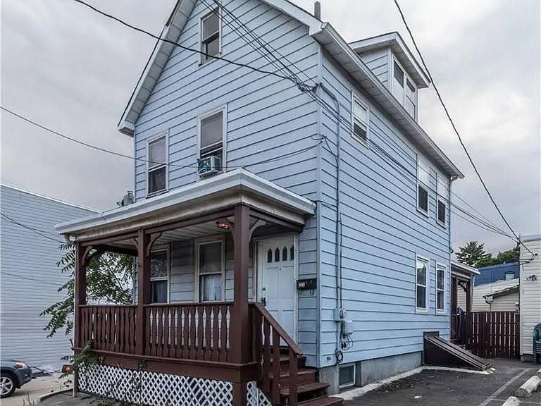
325 Pershing Ave
Carteret, NJ 07008
-
Bedrooms
4
-
Bathrooms
2
-
Square Feet
3,450 sq ft
-
Available
Available Now
Highlight
- Smoke Free

About This Home
4 bedroom 1 family house for rent address 325 Pershing avenue carteret New Jersey 07008 rent 2800 a month 1 month deposit 2800 landlord pay for electric tenant pay for electric and gas 4 bedroom 1 family house for rent have 4 bedroom and 1 kitchen and 1 living room and 2 bathroom 1 bathroom is full bathroom and 1 bathroom is 1 half bathroom and 1 attic and 1 basement no cats or dogs allow inside the property lease term 1 year higher higher is only if the tenant want if you interest looking at the 4 bedroom 1 family house for rent call 1 if you can not call us email us at
325 Pershing Ave is a house located in Middlesex County and the 07008 ZIP Code. This area is served by the Carteret Public attendance zone.
House Features
- Heating
- Smoke Free
Fees and Policies
The fees below are based on community-supplied data and may exclude additional fees and utilities.
- Parking
-
Other--Assigned Parking
Details
Utilities Included
-
Water
Lease Options
-
12 Months
Contact
- Phone Number
- Website View Property Website
- Contact
-
Source

- Heating
- Smoke Free
Located directly across the Arthur Kill from Staten Island, Carteret was once part of the Woodbridge Township. It became the borough of Roosevelt in 1906 and was renamed Carteret in 1922. This popular community is bordered by the Rahway River to the north, Arthur Kill to the east, and the Ernest L. Oros Wildlife Preserve to the west. Due to its central location, the borough bills itself as the "Center of it All."
Residents enjoy a fantastic location and beautiful parks. Carteret Waterfront Park has a fishing pier and access to two hiking trails: Danielle's Garden Trail and the Waterfront Fitness Trail. Shopping in Carteret is plentiful -- the brick-paved sidewalks and outdoor cafes along Washington Avenue provide historic charm and locally-owned businesses, while the shops and restaurants along Roosevelt Avenue have a more modern feel. With just 22 miles to Manhattan, 10 miles to Newark, and 70 miles to Philadelphia, residents can easily commute to nearby cities.
Learn more about living in Carteret| Colleges & Universities | Distance | ||
|---|---|---|---|
| Colleges & Universities | Distance | ||
| Drive: | 14 min | 7.4 mi | |
| Drive: | 17 min | 9.0 mi | |
| Drive: | 18 min | 10.3 mi | |
| Drive: | 23 min | 13.2 mi |


View GreatSchools Rating Methodology
Data provided by GreatSchools.org © 2025. All rights reserved.
Transportation options available in Carteret include 8Th Street Light Rail Station, located 11.8 miles from 325 Pershing Ave. 325 Pershing Ave is near Newark Liberty International, located 13.5 miles or 21 minutes away, and LaGuardia, located 30.8 miles or 50 minutes away.
| Transit / Subway | Distance | ||
|---|---|---|---|
| Transit / Subway | Distance | ||
| Drive: | 20 min | 11.8 mi | |
|
|
Drive: | 22 min | 13.1 mi |
|
|
Drive: | 21 min | 14.7 mi |
|
|
Drive: | 20 min | 14.7 mi |
| Commuter Rail | Distance | ||
|---|---|---|---|
| Commuter Rail | Distance | ||
|
|
Drive: | 9 min | 4.2 mi |
|
|
Drive: | 9 min | 4.8 mi |
|
|
Drive: | 10 min | 5.1 mi |
|
|
Drive: | 13 min | 6.6 mi |
|
|
Drive: | 23 min | 12.7 mi |
| Airports | Distance | ||
|---|---|---|---|
| Airports | Distance | ||
|
Newark Liberty International
|
Drive: | 21 min | 13.5 mi |
|
LaGuardia
|
Drive: | 50 min | 30.8 mi |
Time and distance from 325 Pershing Ave.
| Shopping Centers | Distance | ||
|---|---|---|---|
| Shopping Centers | Distance | ||
| Walk: | 15 min | 0.8 mi | |
| Walk: | 18 min | 0.9 mi | |
| Drive: | 16 min | 9.7 mi |
| Parks and Recreation | Distance | ||
|---|---|---|---|
| Parks and Recreation | Distance | ||
|
Liberty State Park
|
Drive: | 5 min | 1.8 mi |
|
Hawk Rise Sanctuary
|
Drive: | 12 min | 5.2 mi |
|
Staten Island Industrial Park
|
Drive: | 15 min | 9.3 mi |
|
William T. Davis Wildlife Refuge
|
Drive: | 17 min | 10.5 mi |
|
Freshkills Park
|
Drive: | 23 min | 13.3 mi |
| Hospitals | Distance | ||
|---|---|---|---|
| Hospitals | Distance | ||
| Drive: | 12 min | 5.2 mi | |
| Drive: | 13 min | 7.1 mi | |
| Drive: | 15 min | 7.8 mi |
| Military Bases | Distance | ||
|---|---|---|---|
| Military Bases | Distance | ||
| Drive: | 19 min | 8.2 mi | |
| Drive: | 22 min | 8.9 mi | |
| Drive: | 26 min | 14.8 mi |
You May Also Like
What Are Walk Score®, Transit Score®, and Bike Score® Ratings?
Walk Score® measures the walkability of any address. Transit Score® measures access to public transit. Bike Score® measures the bikeability of any address.
What is a Sound Score Rating?
A Sound Score Rating aggregates noise caused by vehicle traffic, airplane traffic and local sources

325 Pershing Ave
Carteret, NJ 07008