
$4,800
/ Month
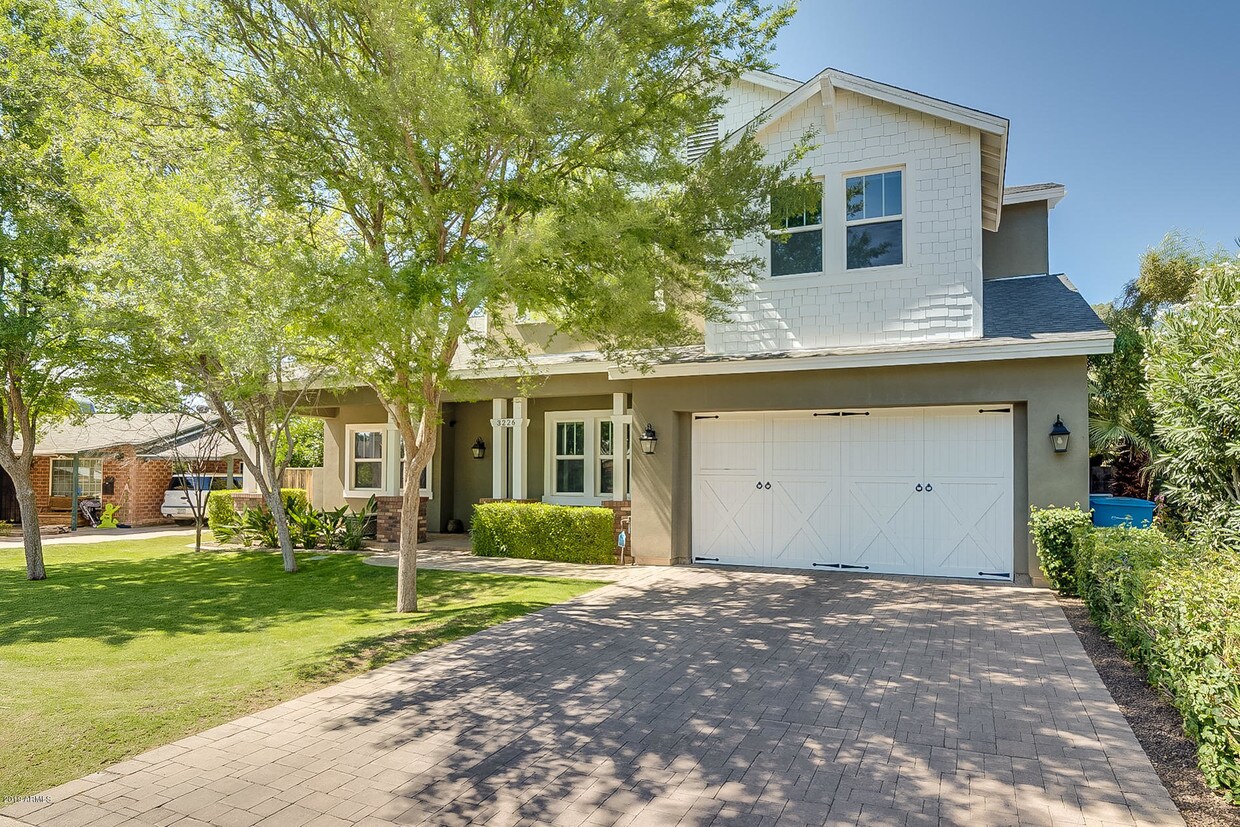
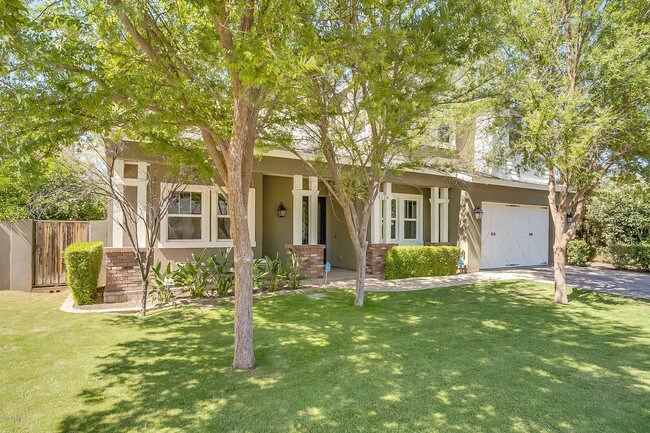
3226 E Sells Dr
Phoenix, AZ 85018
2 Weeks Ago
|
Edit
Favorites
3226 E Sells Dr

Favorites
Check Back Soon for Upcoming Availability
| Beds | Baths | Average SF |
|---|---|---|
| 4 Bedrooms 4 Bedrooms 4 Br | 3.5 Baths 3.5 Baths 3.5 Ba | — |
About This Property
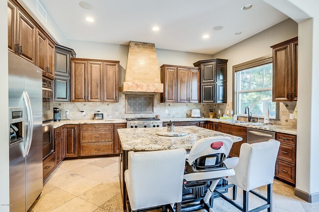
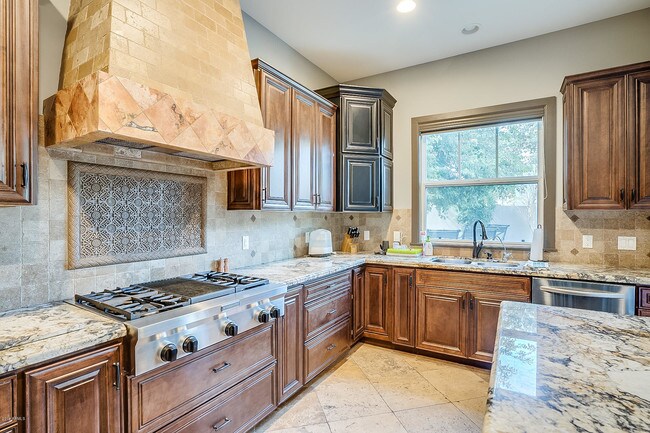
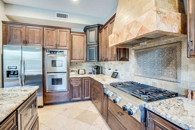
Gorgeous home in an unbelievable neighborhood! Can't beat this location, right in between the Biltmore and Arcadia. Walking distance from LGO, Postino Wine Bar and The Original Chop Shop. Custom built in 2010, chef-style open kitchen, perfect entertaining backyard that includes lush landscaping and private pool/spa. 4Bed/3.5Bath plus office and a fantastic loft (bonus rom) with gorgeous views of Squaw Peak! This is a neighborhood hotspot with new homes popping up on every street. Come take a look!
3226 E Sells Dr is a house located in Maricopa County and the 85018 ZIP Code. This area is served by the Phoenix Union High attendance zone.
Location
Get Directions
East Phoenix, also known as Camelback East, is a vibrant suburb situated between Old Town Scottsdale and Downtown Phoenix. The neighborhood is teeming with a wide variety of shopping and dining options in numerous plazas and shopping centers along East Camelback Road, East Indian School Road, and Thomas Road.
Outdoor destinations like Phoenix Mountains Preserve, Echo Canyon Recreation Area, Papago Park, and Tempe Beach Park are all located within minutes of East Phoenix, providing ample opportunities to enjoy the area’s natural beauty. Traveling and commuting from East Phoenix is easy with access to Phoenix Sky Harbor International Airport and multiple major freeways.
Learn more about living in East PhoenixBelow are rent ranges for similar nearby apartments
| Beds | Average Size | Lowest | Typical | Premium |
|---|---|---|---|---|
| Studio Studio Studio | 400 Sq Ft | $675 | $1,020 | $2,599 |
| 1 Bed 1 Bed 1 Bed | 651-652 Sq Ft | $804 | $1,357 | $11,120 |
| 2 Beds 2 Beds 2 Beds | 1022-1023 Sq Ft | $860 | $1,795 | $6,500 |
| 3 Beds 3 Beds 3 Beds | 1605 Sq Ft | $1,699 | $3,570 | $12,950 |
| 4 Beds 4 Beds 4 Beds | 2893 Sq Ft | $2,489 | $12,061 | $50,000 |
Education
| Colleges & Universities | Distance | ||
|---|---|---|---|
| Colleges & Universities | Distance | ||
| Drive: | 9 min | 4.7 mi | |
| Drive: | 12 min | 5.6 mi | |
| Drive: | 11 min | 6.5 mi | |
| Drive: | 12 min | 6.8 mi |
3226 E Sells Dr is within 9 minutes or 4.7 miles from Gateway Community College. It is also near Phoenix College and University of Arizona.
Schools


Public Elementary & Middle School
Grades K-8
544 Students
Attendance Zone
Public High School
Grades 9-12
276 Students
Attendance Zone
Public High School
Grades 9-12
2,238 Students
Attendance Zone
Private Elementary, Middle & High School
Grades PK-12
757 Students
Nearby
Private Elementary & Middle School
Grades PK-8
554 Students
Nearby
School data provided by
 The GreatSchools Rating helps parents compare schools within a state based on a variety of school quality indicators and provides a helpful picture of how effectively each school serves all of its students. Ratings are on a scale of 1 (below average) to 10 (above average) and can include test scores, college readiness, academic progress, advanced courses, equity, discipline and attendance data. We also advise parents to visit schools, consider other information on school performance and programs, and consider family needs as part of the school selection process.
View GreatSchools Rating Methodology
Data provided by GreatSchools.org © 2025. All rights reserved.
View GreatSchools Rating Methodology
Data provided by GreatSchools.org © 2025. All rights reserved.
Transportation options available in Phoenix include Indian School/Central Ave, located 4.4 miles from 3226 E Sells Dr. 3226 E Sells Dr is near Phoenix Sky Harbor International, located 7.6 miles or 14 minutes away, and Phoenix-Mesa Gateway, located 32.4 miles or 46 minutes away.
| Transit / Subway | Distance | ||
|---|---|---|---|
| Transit / Subway | Distance | ||
|
|
Drive: | 9 min | 4.4 mi |
|
|
Drive: | 8 min | 4.5 mi |
|
|
Drive: | 9 min | 4.6 mi |
|
|
Drive: | 10 min | 4.6 mi |
|
|
Drive: | 10 min | 4.6 mi |
| Commuter Rail | Distance | ||
|---|---|---|---|
| Commuter Rail | Distance | ||
|
|
Drive: | 47 min | 33.8 mi |
| Airports | Distance | ||
|---|---|---|---|
| Airports | Distance | ||
|
Phoenix Sky Harbor International
|
Drive: | 14 min | 7.6 mi |
|
Phoenix-Mesa Gateway
|
Drive: | 46 min | 32.4 mi |
Time and distance from 3226 E Sells Dr.
| Shopping Centers | Distance | ||
|---|---|---|---|
| Shopping Centers | Distance | ||
| Walk: | 10 min | 0.5 mi | |
| Walk: | 12 min | 0.7 mi | |
| Walk: | 13 min | 0.7 mi |
3226 E Sells Dr has 3 shopping centers within 0.7 mile, which is about a 13-minute walk. The miles and minutes will be for the farthest away property.
| Parks and Recreation | Distance | ||
|---|---|---|---|
| Parks and Recreation | Distance | ||
|
Tonto National Forest
|
Walk: | 13 min | 0.7 mi |
|
Arcadia Park
|
Drive: | 6 min | 3.5 mi |
|
Steele Indian School Park
|
Drive: | 8 min | 3.8 mi |
|
Granada Park
|
Drive: | 9 min | 4.2 mi |
|
Desert Storm Park
|
Drive: | 10 min | 4.6 mi |
3226 E Sells Dr has 5 parks within 4.6 miles, including Tonto National Forest, Desert Storm Park, and Granada Park.
| Hospitals | Distance | ||
|---|---|---|---|
| Hospitals | Distance | ||
| Drive: | 3 min | 2.0 mi | |
| Drive: | 5 min | 2.7 mi | |
| Drive: | 6 min | 3.2 mi |
3226 E Sells Dr has 3 hospitals within 3.2 miles, the nearest is Valley Hospital which is 2.0 miles away and a 3 minute drive.
| Military Bases | Distance | ||
|---|---|---|---|
| Military Bases | Distance | ||
| Drive: | 15 min | 7.7 mi | |
| Drive: | 37 min | 27.4 mi | |
| Drive: | 105 min | 79.9 mi |
3226 E Sells Dr has 3 military bases within 79.9 miles, the nearest is Phoenix Sky Harbor Airport Air Guard Station which is 7.7 miles away and a 15 minute drive.
You May Also Like
Similar Rentals Nearby


What Are Walk Score®, Transit Score®, and Bike Score® Ratings?
Walk Score® measures the walkability of any address. Transit Score® measures access to public transit. Bike Score® measures the bikeability of any address.
What is a Sound Score Rating?
A Sound Score Rating aggregates noise caused by vehicle traffic, airplane traffic and local sources

3226 E Sells Dr
Phoenix, AZ 85018