-
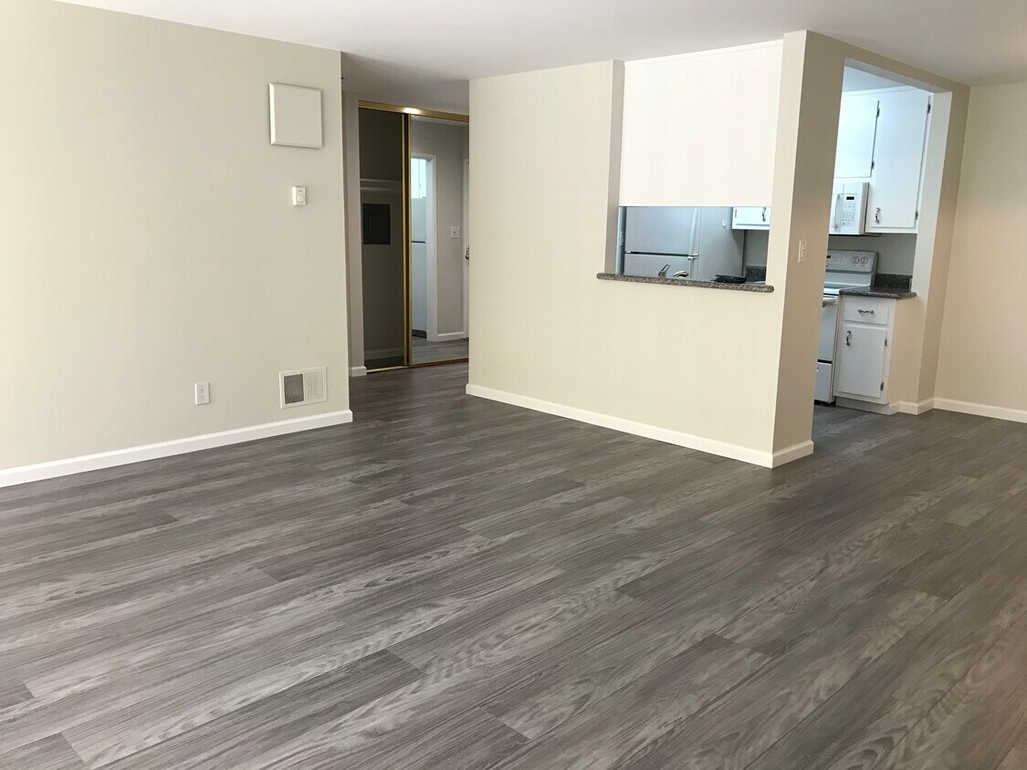
Living Room
3222 Glendora Dr
3222 Glendora Dr,
San Mateo,
CA
94403
2 Weeks Ago
Favorites
3222 Glendora Dr

Favorites
Check Back Soon for Upcoming Availability
Fees and Policies
The fees below are based on community-supplied data and may exclude additional fees and utilities.
- Parking
-
Garage--
Details
Lease Options
-
12 Months
About 3222 Glendora Dr San Mateo, CA 94403
Hidden gem located in an apartment complex in the Sugarloaf neighborhood. This 1BDR/1BTH unit is only a walk away from Laurelwood Shopping Center with various types of shops and restaurants at your fingertips. More of a nature person? This unit is also nearby Laurelwood Park, San Mateo’s largest park, offering hiking trails and scenic views. Only a three minute drive to the College of San Mateo and the CA-92 freeway. This 1BDR/1BTH unit offers plenty of space for an individual or a couple. Nice hardwood flooring throughout the apartment with plenty of natural light seeping through the windows. Kitchen is equipped with an electric stove, a stainless steel sink, dishwasher, and granite countertops. Spacious balcony that allows for more room to entertain or relax on a warm day. Assigned parking included along with access to a heated pool. This price is our six-month special! Previously, the unit was listed as $2,695 for a 12-month lease. Please contact us if you have further questions or inquiry.
3222 Glendora Dr is an apartment community located in San Mateo County and the 94403 ZIP Code.
Apartment Features
- Laundry Facilities
Location
Get Directions
Located about halfway between San Francisco and San Jose, Sugarloaf is a peaceful, suburban neighborhood in San Mateo. Sugarloaf is predominantly residential, touting an array of single-family houses and apartment buildings atop scenic hillsides. However, Sugarloaf also provides plenty of shopping opportunities, from the extensive retail offerings of the Hillsdale Shopping Center to the unique finds in local shops along 37th Avenue.
Sugarloaf residents enjoy ample outdoor activities at the sprawling Laurelwood Park in addition to quick commutes for those working at the San Mateo Medical Center and the College of San Mateo. Convenience to El Camino Real, J. Arthur Younger Freeway, the Hillsdale CalTrain Station, and San Francisco International Airport makes getting around from Sugarloaf a breeze.
Learn more about living in SugarloafBelow are rent ranges for similar nearby apartments
| Beds | Average Size | Lowest | Typical | Premium |
|---|---|---|---|---|
| Studio Studio Studio | 454 Sq Ft | $1,925 | $2,306 | $2,708 |
| 1 Bed 1 Bed 1 Bed | 704 Sq Ft | $2,395 | $3,069 | $3,382 |
| 2 Beds 2 Beds 2 Beds | 942-953 Sq Ft | $2,895 | $3,723 | $4,454 |
| 3 Beds 3 Beds 3 Beds | 2415 Sq Ft | $4,023 | $4,819 | $6,000 |
| 4 Beds 4 Beds 4 Beds | 2775 Sq Ft | $7,490 | $7,742 | $7,995 |
Amenities
- Laundry Facilities
Education
| Colleges & Universities | Distance | ||
|---|---|---|---|
| Colleges & Universities | Distance | ||
| Walk: | 20 min | 1.0 mi | |
| Drive: | 15 min | 9.8 mi | |
| Drive: | 20 min | 13.5 mi | |
| Drive: | 20 min | 13.9 mi |
3222 Glendora Dr is within 20 minutes or 1.0 miles from College of San Mateo. It is also near Canada College and Menlo College.
Transportation options available in San Mateo include Millbrae (Caltrain Transfer Platform), located 7.5 miles from 3222 Glendora Dr. 3222 Glendora Dr is near San Francisco International, located 11.2 miles or 16 minutes away, and Metro Oakland International, located 26.7 miles or 34 minutes away.
| Transit / Subway | Distance | ||
|---|---|---|---|
| Transit / Subway | Distance | ||
|
|
Drive: | 14 min | 7.5 mi |
|
|
Drive: | 14 min | 7.5 mi |
|
|
Drive: | 15 min | 10.7 mi |
| Drive: | 16 min | 10.8 mi | |
|
|
Drive: | 16 min | 11.0 mi |
| Commuter Rail | Distance | ||
|---|---|---|---|
| Commuter Rail | Distance | ||
| Drive: | 5 min | 1.8 mi | |
| Drive: | 5 min | 2.8 mi | |
| Drive: | 5 min | 2.8 mi | |
| Drive: | 7 min | 4.1 mi | |
| Drive: | 8 min | 5.7 mi |
| Airports | Distance | ||
|---|---|---|---|
| Airports | Distance | ||
|
San Francisco International
|
Drive: | 16 min | 11.2 mi |
|
Metro Oakland International
|
Drive: | 34 min | 26.7 mi |
Time and distance from 3222 Glendora Dr.
| Shopping Centers | Distance | ||
|---|---|---|---|
| Shopping Centers | Distance | ||
| Walk: | 5 min | 0.3 mi | |
| Drive: | 3 min | 1.3 mi | |
| Drive: | 3 min | 2.2 mi |
3222 Glendora Dr has 3 shopping centers within 2.2 miles, which is about a 3-minute walk. The miles and minutes will be for the farthest away property.
| Parks and Recreation | Distance | ||
|---|---|---|---|
| Parks and Recreation | Distance | ||
|
San Mateo Arboretum
|
Drive: | 5 min | 3.1 mi |
|
Japanese Tea Garden (San Mateo)
|
Drive: | 6 min | 3.4 mi |
|
Crystal Springs Trail
|
Drive: | 7 min | 4.6 mi |
|
Shoreline Parks
|
Drive: | 9 min | 5.7 mi |
|
Coyote Point Recreational Area
|
Drive: | 12 min | 7.0 mi |
3222 Glendora Dr has 5 parks within 7.0 miles, including Crystal Springs Trail, San Mateo Arboretum, and Japanese Tea Garden (San Mateo).
| Hospitals | Distance | ||
|---|---|---|---|
| Hospitals | Distance | ||
| Drive: | 5 min | 2.0 mi | |
| Drive: | 12 min | 7.0 mi | |
| Drive: | 14 min | 9.2 mi |
3222 Glendora Dr has 3 hospitals within 9.2 miles, the nearest is San Mateo Medical Center which is 2.0 miles away and a 5 minute drive.
| Military Bases | Distance | ||
|---|---|---|---|
| Military Bases | Distance | ||
| Drive: | 29 min | 21.0 mi |
3222 Glendora Dr is 21.0 miles and a 29 minute drive from Ames Research Center.
You May Also Like
Similar Rentals Nearby


What Are Walk Score®, Transit Score®, and Bike Score® Ratings?
Walk Score® measures the walkability of any address. Transit Score® measures access to public transit. Bike Score® measures the bikeability of any address.
What is a Sound Score Rating?
A Sound Score Rating aggregates noise caused by vehicle traffic, airplane traffic and local sources