
The Vitagraph
1277 E 14th St,
Brooklyn, NY 11230
$2,770 - $4,308
1-3 Beds
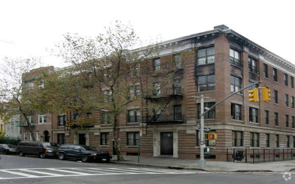

Enjoy Brooklyn living at 320-322 New York Ave. The 320-322 New York Ave location in Brooklyn's 11213 area is an ideal place for residents. The team of leasing professionals is ready and waiting for you to visit. Schedule a time to see the current floorplan options. At 320-322 New York Ave you're new apartment awaits. Stop by the community today.
320-322 New York Ave is an apartment community located in Kings County and the 11213 ZIP Code. This area is served by the New York City Geographic District #17 attendance zone.
High Speed Internet Access
Refrigerator
Smoke Free
Heating
Crown Heights is a central neighborhood in New York’s bustling borough of Brooklyn. Just minutes from the Brooklyn Botanic Garden and the Brooklyn Museum, Crown Heights’ residents have convenient access to some of Brooklyn’s greatest attractions.
Take the whole family to the Brooklyn Children’s Museum to explore the world’s first children’s museum, opened in 1899. Many community parks are available in the neighborhood, such as St. Johns Park, equipped with ball fields, basketball courts, and a recreation center. Enjoy a handcrafted burger paired with a craft beer at Boeuf & Bun, an upbeat local spot in Crown Heights. There’s a variety of apartments and condos available for rent in this central Brooklyn neighborhood.
Learn more about living in Crown HeightsCompare neighborhood and city base rent averages by bedroom.
| Crown Heights | Brooklyn, NY | |
|---|---|---|
| Studio | $2,195 | $2,693 |
| 1 Bedroom | $2,683 | $3,044 |
| 2 Bedrooms | $3,165 | $3,972 |
| 3 Bedrooms | $3,189 | $4,922 |
| Colleges & Universities | Distance | ||
|---|---|---|---|
| Colleges & Universities | Distance | ||
| Walk: | 12 min | 0.7 mi | |
| Drive: | 7 min | 2.2 mi | |
| Drive: | 6 min | 2.4 mi | |
| Drive: | 7 min | 2.7 mi |


Transportation options available in Brooklyn include President Street, located 0.2 mile from 320-322 New York Ave. 320-322 New York Ave is near LaGuardia, located 11.2 miles or 23 minutes away, and John F Kennedy International, located 11.7 miles or 21 minutes away.
| Transit / Subway | Distance | ||
|---|---|---|---|
| Transit / Subway | Distance | ||
|
|
Walk: | 3 min | 0.2 mi |
|
|
Walk: | 3 min | 0.2 mi |
|
|
Walk: | 7 min | 0.4 mi |
|
|
Walk: | 10 min | 0.5 mi |
|
|
Walk: | 11 min | 0.6 mi |
| Commuter Rail | Distance | ||
|---|---|---|---|
| Commuter Rail | Distance | ||
|
|
Drive: | 4 min | 1.2 mi |
|
|
Drive: | 7 min | 2.2 mi |
|
|
Drive: | 6 min | 2.6 mi |
|
|
Drive: | 17 min | 6.8 mi |
|
|
Drive: | 18 min | 7.1 mi |
| Airports | Distance | ||
|---|---|---|---|
| Airports | Distance | ||
|
LaGuardia
|
Drive: | 23 min | 11.2 mi |
|
John F Kennedy International
|
Drive: | 21 min | 11.7 mi |
Scores provided by
Traffic
-Airport
-Businesses
-Scores provided by
HowLoud What is a Sound Score Rating? A Sound Score Rating aggregates noise caused by vehicle traffic, airplane traffic and local sources. How It WorksTime and distance from 320-322 New York Ave.
| Shopping Centers | Distance | ||
|---|---|---|---|
| Shopping Centers | Distance | ||
| Drive: | 5 min | 1.3 mi | |
| Drive: | 5 min | 1.7 mi |
| Parks and Recreation | Distance | ||
|---|---|---|---|
| Parks and Recreation | Distance | ||
|
Brooklyn Children's Museum
|
Walk: | 11 min | 0.6 mi |
|
Wingate Park
|
Walk: | 17 min | 0.9 mi |
|
Brooklyn Botanic Garden
|
Drive: | 3 min | 1.1 mi |
|
St. John's Park
|
Drive: | 5 min | 1.4 mi |
|
Prospect Park Audubon Center at the Boathouse
|
Drive: | 4 min | 1.7 mi |
| Hospitals | Distance | ||
|---|---|---|---|
| Hospitals | Distance | ||
| Drive: | 5 min | 1.3 mi | |
| Drive: | 6 min | 1.3 mi | |
| Drive: | 6 min | 1.4 mi |
| Military Bases | Distance | ||
|---|---|---|---|
| Military Bases | Distance | ||
| Drive: | 19 min | 7.5 mi | |
| Drive: | 18 min | 7.6 mi | |
| Drive: | 26 min | 9.4 mi |
What Are Walk Score®, Transit Score®, and Bike Score® Ratings?
Walk Score® measures the walkability of any address. Transit Score® measures access to public transit. Bike Score® measures the bikeability of any address.
What is a Sound Score Rating?
A Sound Score Rating aggregates noise caused by vehicle traffic, airplane traffic and local sources.


