


$2,300
/ Month
32 Marley Ave
Cedar Grove, NJ 07009
2 Weeks Ago
Favorites
32 Marley Ave

Favorites
Check Back Soon for Upcoming Availability
| Beds | Baths | Average SF |
|---|---|---|
| 2 Bedrooms 2 Bedrooms 2 Br | 1 Bath 1 Bath 1 Ba | — |
Fees and Policies
The fees below are based on community-supplied data and may exclude additional fees and utilities.
- Cats Allowed
-
Fees not specified
-
Weight limit--
-
Pet Limit--
- Parking
-
Garage--
About This Property
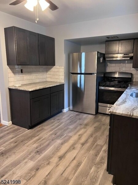
Don't miss your chance to live in a wonderful community in this fabulous updated 2nd floor apartment located on a quiet dead end street. This entire apartment has been freshly painted and features an updated eat in kitchen with all new appliances. The primary bedroom spans the entire width of the house and features a large walk in closet. Bedroom number two is large enough to accommodate a queen bed with two closets and access to the attic for more storage. In addition to the living room, there is a spacious flex space with a large storage closet and the full bath has a tub/shower with plenty of storage space. Access to private attic storage space. Tenants have use of the washer and dryer in the basement, one garage space and one driveway space. This home is located in close proximity to the train and bus as well as all major highways and the elementary school.
32 Marley Ave is a house located in Essex County and the 07009 ZIP Code. This area is served by the Cedar Grove Township attendance zone.
Location
Get Directions
Located about 20 miles northwest of New York City, Cedar Grove provides residents with a tranquil small-town atmosphere in Essex County. Pompton Avenue is Cedar Grove’s main commercial thoroughfare, where a bevy of quaint shops and diverse restaurants sit along a tree-lined street.
Several parks offer plenty of options for outdoor recreation in Cedar Grove, including the expansive Mills Reservation County Park, Hilltop Reservation, and Cedar Grove Community Park. Cedar Grove is also within minutes of Verona Park, Eagle Rock Reservation, and Brookdale Park. Quick access to numerous NJ Transit rail stations and major highways affords residents easy commutes and travels from Cedar Grove.
Learn more about living in Cedar Grove
Education
| Colleges & Universities | Distance | ||
|---|---|---|---|
| Colleges & Universities | Distance | ||
| Drive: | 6 min | 2.5 mi | |
| Drive: | 9 min | 4.4 mi | |
| Drive: | 8 min | 4.5 mi | |
| Drive: | 10 min | 6.4 mi |
32 Marley Ave is within 6 minutes or 2.5 miles from Montclair State University. It is also near Berkeley College and Caldwell College.
Schools


Public Elementary School
Grades PK-4
305 Students
Nearby
Public Elementary & Middle School
Grades 5-8
388 Students
Nearby
Public High School
Grades 9-12
466 Students
Attendance Zone
Private Elementary & Middle School
Grades K-8
Nearby
Private Elementary School
Grades PK-2
18 Students
Nearby
Private Elementary & Middle School
Grades 1-9
60 Students
Nearby
Private Elementary, Middle & High School
Grades 5-12
Nearby
School data provided by
 The GreatSchools Rating helps parents compare schools within a state based on a variety of school quality indicators and provides a helpful picture of how effectively each school serves all of its students. Ratings are on a scale of 1 (below average) to 10 (above average) and can include test scores, college readiness, academic progress, advanced courses, equity, discipline and attendance data. We also advise parents to visit schools, consider other information on school performance and programs, and consider family needs as part of the school selection process.
View GreatSchools Rating Methodology
Data provided by GreatSchools.org © 2025. All rights reserved.
View GreatSchools Rating Methodology
Data provided by GreatSchools.org © 2025. All rights reserved.
Transportation options available in Cedar Grove include Grove Street, located 7.7 miles from 32 Marley Ave. 32 Marley Ave is near Newark Liberty International, located 20.8 miles or 25 minutes away, and LaGuardia, located 29.7 miles or 43 minutes away.
| Transit / Subway | Distance | ||
|---|---|---|---|
| Transit / Subway | Distance | ||
|
|
Drive: | 14 min | 7.7 mi |
|
|
Drive: | 15 min | 8.1 mi |
|
|
Drive: | 15 min | 8.3 mi |
|
|
Drive: | 15 min | 8.4 mi |
|
|
Drive: | 15 min | 8.7 mi |
| Commuter Rail | Distance | ||
|---|---|---|---|
| Commuter Rail | Distance | ||
|
|
Walk: | 15 min | 0.8 mi |
|
|
Drive: | 5 min | 2.5 mi |
|
|
Drive: | 6 min | 3.3 mi |
|
|
Drive: | 7 min | 3.3 mi |
|
|
Drive: | 6 min | 3.4 mi |
| Airports | Distance | ||
|---|---|---|---|
| Airports | Distance | ||
|
Newark Liberty International
|
Drive: | 25 min | 20.8 mi |
|
LaGuardia
|
Drive: | 43 min | 29.7 mi |
Time and distance from 32 Marley Ave.
| Shopping Centers | Distance | ||
|---|---|---|---|
| Shopping Centers | Distance | ||
| Drive: | 2 min | 1.2 mi | |
| Drive: | 4 min | 1.6 mi | |
| Drive: | 4 min | 1.6 mi |
32 Marley Ave has 3 shopping centers within 1.6 miles, which is about a 4-minute drive. The miles and minutes will be for the farthest away property.
| Parks and Recreation | Distance | ||
|---|---|---|---|
| Parks and Recreation | Distance | ||
|
Presby Memorial Iris Gardens
|
Drive: | 6 min | 2.9 mi |
|
Van Vleck House & Gardens
|
Drive: | 8 min | 4.4 mi |
|
Fairfield Farm
|
Drive: | 12 min | 6.5 mi |
|
Edison National Historic Site
|
Drive: | 16 min | 8.2 mi |
|
NJ Audubon Essex County Environmental Center
|
Drive: | 14 min | 8.6 mi |
32 Marley Ave has 5 parks within 8.6 miles, including Presby Memorial Iris Gardens, Van Vleck House & Gardens, and Fairfield Farm.
| Hospitals | Distance | ||
|---|---|---|---|
| Hospitals | Distance | ||
| Drive: | 3 min | 1.9 mi | |
| Drive: | 9 min | 6.0 mi | |
| Drive: | 11 min | 7.2 mi |
32 Marley Ave has 3 hospitals within 7.2 miles, the nearest is Essex County Hospital Center which is 1.9 miles away and a 3 minute drive.
| Military Bases | Distance | ||
|---|---|---|---|
| Military Bases | Distance | ||
| Drive: | 33 min | 20.1 mi | |
| Drive: | 34 min | 23.0 mi |
32 Marley Ave is 20.1 miles from Military Ocean Terminal, and is convenient to other military bases, including Governors Island Support Center.
You May Also Like
Similar Rentals Nearby


What Are Walk Score®, Transit Score®, and Bike Score® Ratings?
Walk Score® measures the walkability of any address. Transit Score® measures access to public transit. Bike Score® measures the bikeability of any address.
What is a Sound Score Rating?
A Sound Score Rating aggregates noise caused by vehicle traffic, airplane traffic and local sources

32 Marley Ave
Cedar Grove, NJ 07009