

$1,465 / Month
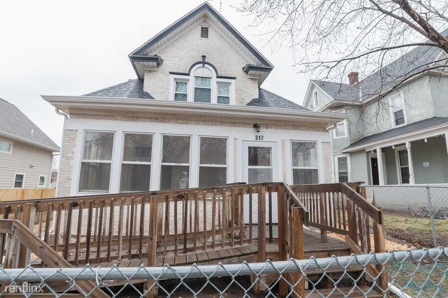
317 30th Ave N
Minneapolis, MN 55411
2 Weeks Ago
Favorites
317 30th Ave N

Favorites
Check Back Soon for Upcoming Availability
| Beds | Baths | Average SF |
|---|---|---|
| 5 Bedrooms 5 Bedrooms 5 Br | 2 Baths 2 Baths 2 Ba | 1,460 SF |
About This Property
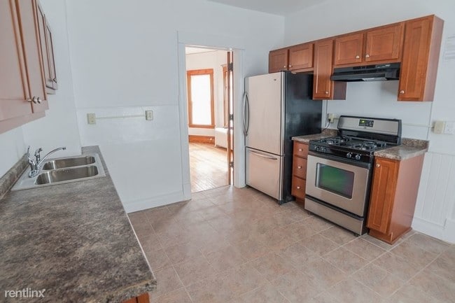
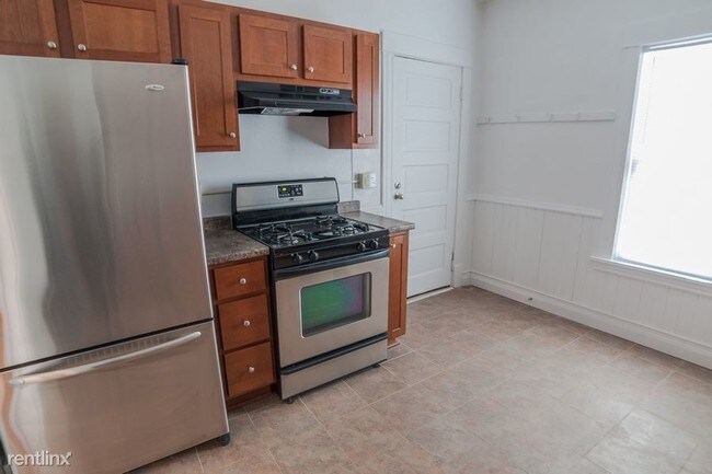
(855) 516-7623 - Now Available! Call us today to schedule your tour! We have local agents waiting to show you our amazing homes and help you through your move in process! Call us at (855) 516-7625 to learn more about renting a HavenBrook home. (RLNE3565662) Other Amenities - Other- Basement. Appliances - Refrigerator, Range, Oven. Lease lengths - Other- Minimum 12 months. Pet policies - Small Dogs Allowed- Breed restrictions may apply, Cats Allowed.
317 30th Ave N is a house located in Hennepin County and the 55411 ZIP Code. This area is served by the Minneapolis Public School Dist. attendance zone.
Location
Get Directions
Urban amenities and outdoor opportunities abound in Hawthorne, a friendly neighborhood that lies three miles north of downtown Minneapolis. Residents come for the charming historic homes and the convenient location, and they stay for the welcoming community atmosphere.
In the center of the neighborhood, Fairview Park attracts crowds with its wading pool, playground, and sports fields. The large hill at the center of the park provides a beautiful view of the Minneapolis skyline. If you're a runner or biker, make the short trek east to the extensive paved path that lines the Mississippi River.
In the south section of Hawthorne, West Broadway Avenue serves as the neighborhood's commercial and social center. For a dose of Minnesota charm, head to Sammy's Avenue Eatery for a sweet tea and the restaurant's legendary turkey pastrami sandwich. At breakfast, it's hard to beat Breaking Bread Cafe, where locals rave about the shrimp and grits.
Learn more about living in HawthorneBelow are rent ranges for similar nearby apartments
Education
| Colleges & Universities | Distance | ||
|---|---|---|---|
| Colleges & Universities | Distance | ||
| Drive: | 9 min | 3.0 mi | |
| Drive: | 8 min | 3.2 mi | |
| Drive: | 11 min | 3.7 mi | |
| Drive: | 12 min | 6.3 mi |
317 30th Ave N is within 9 minutes or 3.0 miles from University of St. Thomas. It is also near Minneapolis College and North Central University.
Schools


Public Elementary School
Grades PK-5
201 Students
Attendance Zone
Public Elementary School
Grades PK-5
200 Students
Attendance Zone
Public Middle School
Grades 6-8
361 Students
Attendance Zone
Public High School
Grades 9-12
858 Students
Attendance Zone
Private Elementary & Middle School
Grades PK-8
148 Students
Nearby
Private Elementary & Middle School
Grades K-8
245 Students
Nearby
Private High School
Grades 9-12
Nearby
School data provided by
 The GreatSchools Rating helps parents compare schools within a state based on a variety of school quality indicators and provides a helpful picture of how effectively each school serves all of its students. Ratings are on a scale of 1 (below average) to 10 (above average) and can include test scores, college readiness, academic progress, advanced courses, equity, discipline and attendance data. We also advise parents to visit schools, consider other information on school performance and programs, and consider family needs as part of the school selection process.
View GreatSchools Rating Methodology
Data provided by GreatSchools.org © 2025. All rights reserved.
View GreatSchools Rating Methodology
Data provided by GreatSchools.org © 2025. All rights reserved.
Transportation options available in Minneapolis include Target Field Station Platform 2, located 2.2 miles from 317 30th Ave N. 317 30th Ave N is near Minneapolis-St Paul International/Wold-Chamberlain, located 14.2 miles or 27 minutes away.
| Transit / Subway | Distance | ||
|---|---|---|---|
| Transit / Subway | Distance | ||
| Drive: | 7 min | 2.2 mi | |
|
|
Drive: | 7 min | 2.3 mi |
|
|
Drive: | 7 min | 2.6 mi |
|
|
Drive: | 8 min | 2.8 mi |
|
|
Drive: | 8 min | 2.9 mi |
| Commuter Rail | Distance | ||
|---|---|---|---|
| Commuter Rail | Distance | ||
|
|
Drive: | 6 min | 2.2 mi |
|
|
Drive: | 11 min | 5.7 mi |
|
|
Drive: | 22 min | 14.1 mi |
|
|
Drive: | 25 min | 16.5 mi |
|
|
Drive: | 26 min | 18.2 mi |
| Airports | Distance | ||
|---|---|---|---|
| Airports | Distance | ||
|
Minneapolis-St Paul International/Wold-Chamberlain
|
Drive: | 27 min | 14.2 mi |
Time and distance from 317 30th Ave N.
| Shopping Centers | Distance | ||
|---|---|---|---|
| Shopping Centers | Distance | ||
| Walk: | 18 min | 1.0 mi | |
| Drive: | 4 min | 1.2 mi | |
| Drive: | 5 min | 1.6 mi |
317 30th Ave N has 3 shopping centers within 1.6 miles, which is about a 5-minute walk. The miles and minutes will be for the farthest away property.
| Parks and Recreation | Distance | ||
|---|---|---|---|
| Parks and Recreation | Distance | ||
|
Farview Park
|
Walk: | 4 min | 0.2 mi |
|
Perkins Hill Park
|
Walk: | 8 min | 0.4 mi |
|
Edgewater Park
|
Walk: | 14 min | 0.8 mi |
|
Orvin ""Ole"" Olson Park
|
Walk: | 20 min | 1.0 mi |
|
Gluek Park
|
Drive: | 3 min | 1.2 mi |
317 30th Ave N has 5 parks within 1.2 miles, including Farview Park, Perkins Hill Park, and Edgewater Park.
| Hospitals | Distance | ||
|---|---|---|---|
| Hospitals | Distance | ||
| Drive: | 5 min | 2.0 mi | |
| Drive: | 10 min | 3.4 mi | |
| Drive: | 11 min | 6.1 mi |
317 30th Ave N has 3 hospitals within 6.1 miles, the nearest is North Memorial Health which is 2.0 miles away and a 5 minute drive.
| Military Bases | Distance | ||
|---|---|---|---|
| Military Bases | Distance | ||
| Drive: | 22 min | 11.2 mi |
317 30th Ave N is 11.2 miles and a 22 minute drive from Fort Snelling Military Reservation.
You May Also Like
Similar Rentals Nearby


What Are Walk Score®, Transit Score®, and Bike Score® Ratings?
Walk Score® measures the walkability of any address. Transit Score® measures access to public transit. Bike Score® measures the bikeability of any address.
What is a Sound Score Rating?
A Sound Score Rating aggregates noise caused by vehicle traffic, airplane traffic and local sources
317 30th Ave N
Minneapolis, MN 55411