
Venue Residences
3688 Overland Ave,
Los Angeles, CA 90034
$3,550 - $4,795
1-2 Beds

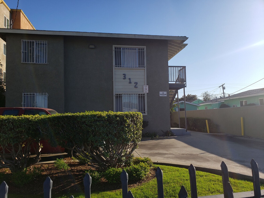
312 W. 120th Street is a vintage 6-unit apartment building featuring 2- and 3-bedroom apartments that was built in 1948. Each apartment features large bedrooms and plenty of storage. Each unit comes with two parking spaces. Upgraded units feature plank flooring and new cabinets. The building is conveniently located close to the 110, 105 and 91 freeways. Shopping and dining are within .5 mile.
312 W 120th St is an apartment community located in Los Angeles County and the 90061 ZIP Code. This area is served by the Los Angeles Unified Rocp School District attendance zone.
Unique Features
Harbor Gateway North is a suburb of Los Angeles. This long, vertical area sits in the southern part of the city, around 10 miles from Downtown LA. Although it was originally meant to connect the Pacific Ocean port cities of Wilmington and San Pedro, Harbor Gateway North actually has three addresses: Torrance, Gardena, and Carson. It serves as a growing neighborhood accessible both to Los Angeles and points south, such as San Pedro and San Diego. Residents of this neighborhood appreciate its walkability, bike-friendly streets, and affordable apartments available for rent. Interstates 105, 110, and 405 provide easy access to neighboring cities and attractions.
Learn more about living in Harbor Gateway NorthCompare neighborhood and city base rent averages by bedroom.
| Harbor Gateway North | Los Angeles, CA | |
|---|---|---|
| Studio | $1,033 | $1,710 |
| 1 Bedroom | $1,334 | $2,178 |
| 2 Bedrooms | $1,628 | $3,017 |
| 3 Bedrooms | $2,180 | $4,259 |
| Colleges & Universities | Distance | ||
|---|---|---|---|
| Colleges & Universities | Distance | ||
| Drive: | 6 min | 2.5 mi | |
| Drive: | 9 min | 5.5 mi | |
| Drive: | 11 min | 5.9 mi | |
| Drive: | 13 min | 6.9 mi |


Transportation options available in Los Angeles include Harbor Fwy Station, located 0.7 mile from 312 W 120th St. 312 W 120th St is near Los Angeles International, located 9.6 miles or 15 minutes away, and Long Beach (Daugherty Field), located 13.1 miles or 20 minutes away.
| Transit / Subway | Distance | ||
|---|---|---|---|
| Transit / Subway | Distance | ||
|
|
Walk: | 13 min | 0.7 mi |
|
|
Walk: | 20 min | 1.1 mi |
|
|
Drive: | 3 min | 1.5 mi |
|
|
Drive: | 5 min | 3.1 mi |
|
|
Drive: | 6 min | 3.5 mi |
| Commuter Rail | Distance | ||
|---|---|---|---|
| Commuter Rail | Distance | ||
|
|
Drive: | 15 min | 11.3 mi |
|
|
Drive: | 17 min | 11.5 mi |
|
|
Drive: | 21 min | 12.3 mi |
|
|
Drive: | 24 min | 13.8 mi |
| Drive: | 19 min | 15.3 mi |
| Airports | Distance | ||
|---|---|---|---|
| Airports | Distance | ||
|
Los Angeles International
|
Drive: | 15 min | 9.6 mi |
|
Long Beach (Daugherty Field)
|
Drive: | 20 min | 13.1 mi |
Scores provided by
Traffic
-Airport
-Businesses
-Scores provided by
HowLoud What is a Sound Score Rating? A Sound Score Rating aggregates noise caused by vehicle traffic, airplane traffic and local sources. How It WorksTime and distance from 312 W 120th St.
| Shopping Centers | Distance | ||
|---|---|---|---|
| Shopping Centers | Distance | ||
| Walk: | 12 min | 0.7 mi | |
| Walk: | 16 min | 0.8 mi | |
| Walk: | 16 min | 0.9 mi |
| Parks and Recreation | Distance | ||
|---|---|---|---|
| Parks and Recreation | Distance | ||
|
Watts Towers-Rodia State Park
|
Drive: | 6 min | 3.4 mi |
|
Watts Senior Center & Rose Garden
|
Drive: | 6 min | 3.7 mi |
|
Compton Creek Natural Park at George Washington Elementary
|
Drive: | 6 min | 3.8 mi |
|
Augustus Hawkins Natural Park
|
Drive: | 9 min | 6.6 mi |
|
California Science Center
|
Drive: | 10 min | 6.8 mi |
| Hospitals | Distance | ||
|---|---|---|---|
| Hospitals | Distance | ||
| Drive: | 5 min | 2.0 mi | |
| Drive: | 5 min | 3.1 mi | |
| Drive: | 8 min | 4.9 mi |
| Military Bases | Distance | ||
|---|---|---|---|
| Military Bases | Distance | ||
| Drive: | 11 min | 6.8 mi |
Pets Allowed Fitness Center Business Center Controlled Access Gated Concierge
What Are Walk Score®, Transit Score®, and Bike Score® Ratings?
Walk Score® measures the walkability of any address. Transit Score® measures access to public transit. Bike Score® measures the bikeability of any address.
What is a Sound Score Rating?
A Sound Score Rating aggregates noise caused by vehicle traffic, airplane traffic and local sources.
312 W 120th St
Los Angeles, CA 90061


")


")


