$3,000
Total Monthly Price
305 W Clay Ave Unit 2
Roselle Park, NJ 07204
Today
|
Edit
Favorites
908-344-3743
-
Bedrooms
3
-
Bathrooms
1
-
Square Feet
1,000 sq ft
-
Available
Available Apr 1
Highlights
- Yard
- Smoke Free
305 W Clay Ave Unit 2

Favorites
About This Home
12 Month Lease,
$4,500 deposit,
Available Apr 1
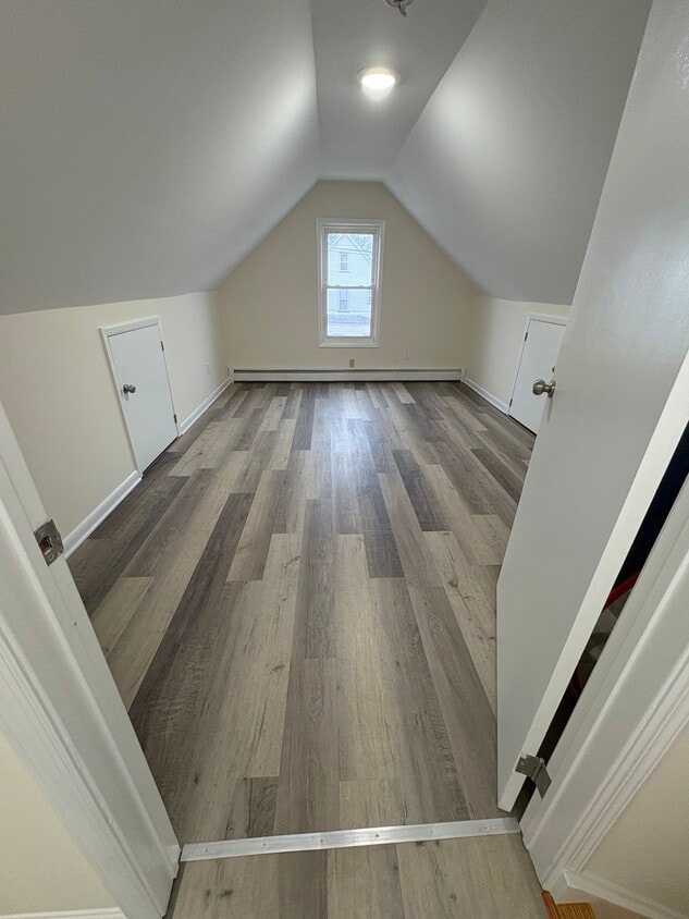
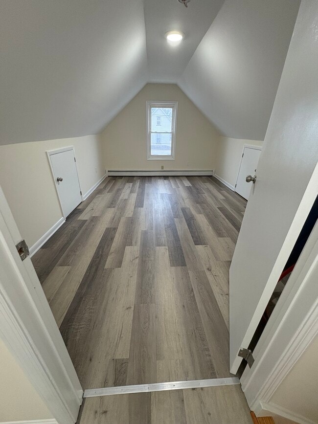
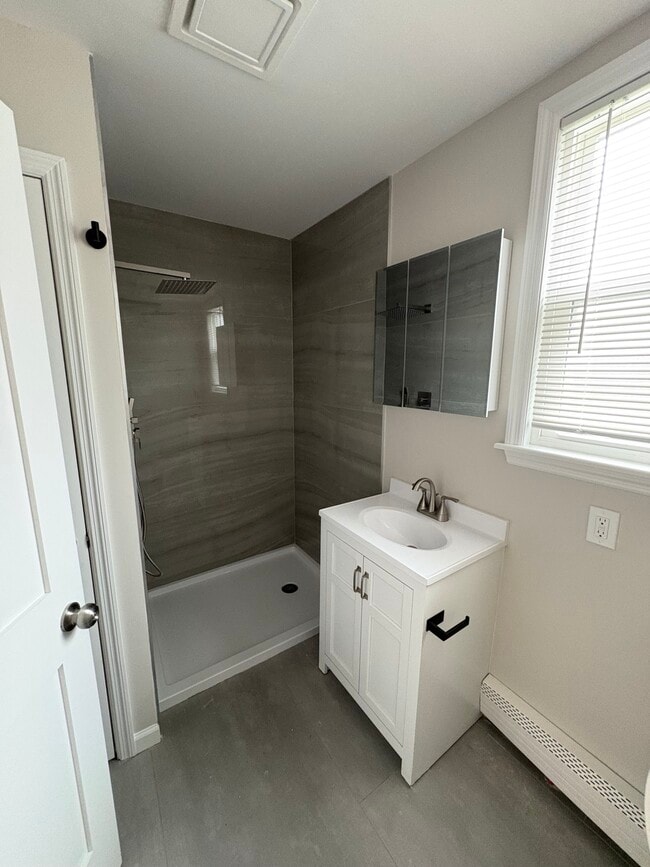
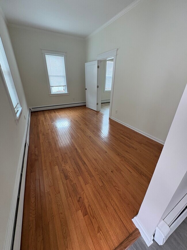
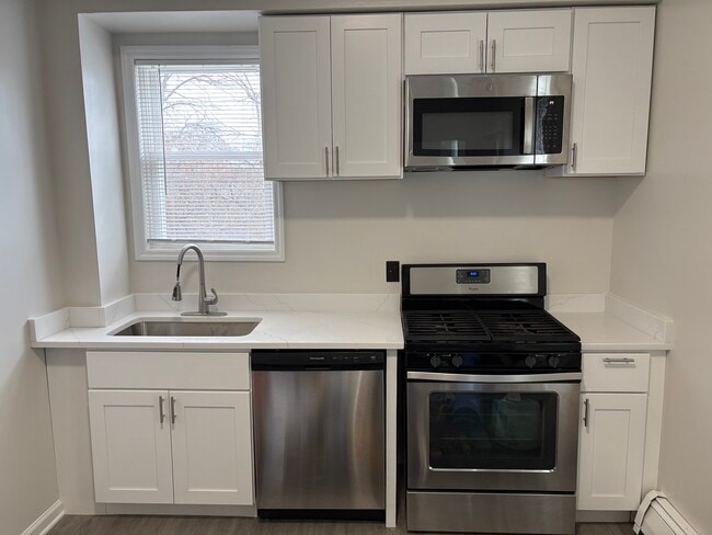
Newly Renovated Apartment with In-Unit Laundry – Roselle Park Beautifully renovated apartment featuring a bright living room, spacious eat-in kitchen with stainless steel appliances, dishwasher, and quartz countertops. The home includes hardwood floors, modern finishes, and plenty of natural light throughout. The main level offers a comfortable bedroom, full bathroom with a modern tiled shower, and convenient in-unit washer and dryer. Upstairs, provides two additional bonus rooms perfect for bedrooms, home offices, playrooms, or extra living space. Located close to parks, shopping, restaurants, and public transportation. Apartment Features • Newly renovated kitchen with quartz countertops • Stainless steel appliances and dishwasher • Spacious living room and eat-in kitchen • In-unit washer and dryer • Updated bathroom with tiled shower • Hardwood floors and new flooring throughout • Plenty of natural light Great layout for families or anyone needing extra space for home offices or guest rooms. Available now.
305 W Clay Ave is an apartment community located in Union County and the 07204 ZIP Code. This area is served by the Roselle Park Board Of Education School District attendance zone.
* Price shown is total price based on community-supplied monthly required fees. Excludes user-selected optional fees and variable or usage-based fees and required charges due at or prior to move-in or at move-out. Price, availability, fees, and any applicable rent special are subject to change without notice.
* Square footage definitions vary. Displayed square footage is approximate.
Apartment Features
Washer/Dryer
Dishwasher
Microwave
Refrigerator
- Washer/Dryer
- Heating
- Smoke Free
- Handrails
- Dishwasher
- Stainless Steel Appliances
- Eat-in Kitchen
- Kitchen
- Microwave
- Oven
- Range
- Refrigerator
- Quartz Countertops
- High Ceilings
- Family Room
- Large Bedrooms
- Yard
Fees and Policies
The fees listed below are community-provided and may exclude utilities or add-ons. All payments are made directly to the property and are non-refundable unless otherwise specified.
- Cats Allowed
-
Fees not specified
-
Weight limit--
-
Pet Limit--
- Parking
-
Street--
Details
Property Information
-
2 units
Contact
- Phone Number
- Contact
Location
Get Directions
Roselle Park is a suburban borough positioned just west of Elizabeth and roughly twenty miles from New York City. Largely a residential community, Roselle Park has become quite popular as a home base for New York area commuters and folks working at the Merck offices just north of town.
The rental market is diverse and rather affordable for the area, and the extremely low crime rate makes it an attractive option for families. Living in Roselle Park will also put you very close to numerous are parks and golf courses, making it easy to spend time outdoors.
Learn more about living in Roselle Park
Education
| Colleges & Universities | Distance | ||
|---|---|---|---|
| Colleges & Universities | Distance | ||
| Drive: | 10 min | 3.2 mi | |
| Drive: | 8 min | 3.4 mi | |
| Drive: | 8 min | 3.5 mi | |
| Drive: | 17 min | 9.3 mi |
305 W Clay Ave Unit 2 is within 8 minutes or 3.5 miles from Kean University. It is also near Union County College, Cranford and Union County Coll., Elizabeth.
Schools

Public Middle School
Grades 6-8
Nearby
Public High School
Grades 9-12
Nearby
School data provided by
 The GreatSchools Rating helps parents compare schools within a state based on a variety of school quality indicators and provides a helpful picture of how effectively each school serves all of its students. Ratings are on a scale of 1 (below average) to 10 (above average) and can include test scores, college readiness, academic progress, advanced courses, equity, discipline and attendance data. We also advise parents to visit schools, consider other information on school performance and programs, and consider family needs as part of the school selection process.
View GreatSchools Rating Methodology
Data provided by GreatSchools.org © 2026. All rights reserved.
View GreatSchools Rating Methodology
Data provided by GreatSchools.org © 2026. All rights reserved.
Transportation options available in Roselle Park include Warren Street, located 9.7 miles from 305 W Clay Ave Unit 2. 305 W Clay Ave Unit 2 is near Newark Liberty International, located 11.4 miles or 15 minutes away, and LaGuardia, located 30.6 miles or 50 minutes away.
| Transit / Subway | Distance | ||
|---|---|---|---|
| Transit / Subway | Distance | ||
|
|
Drive: | 15 min | 9.7 mi |
|
|
Drive: | 15 min | 9.7 mi |
|
|
Drive: | 15 min | 9.9 mi |
|
|
Drive: | 15 min | 10.2 mi |
| Drive: | 20 min | 10.7 mi |
| Commuter Rail | Distance | ||
|---|---|---|---|
| Commuter Rail | Distance | ||
|
|
Walk: | 12 min | 0.6 mi |
|
|
Drive: | 5 min | 1.8 mi |
|
|
Drive: | 7 min | 2.9 mi |
|
|
Drive: | 8 min | 3.3 mi |
|
|
Drive: | 8 min | 3.8 mi |
| Airports | Distance | ||
|---|---|---|---|
| Airports | Distance | ||
|
Newark Liberty International
|
Drive: | 15 min | 11.4 mi |
|
LaGuardia
|
Drive: | 50 min | 30.6 mi |
Time and distance from 305 W Clay Ave Unit 2.
| Shopping Centers | Distance | ||
|---|---|---|---|
| Shopping Centers | Distance | ||
| Drive: | 4 min | 1.5 mi | |
| Drive: | 5 min | 1.6 mi | |
| Drive: | 4 min | 1.7 mi |
305 W Clay Ave Unit 2 has 3 shopping centers within 1.7 miles, which is about a 4-minute drive. The miles and minutes will be for the farthest away property.
| Parks and Recreation | Distance | ||
|---|---|---|---|
| Parks and Recreation | Distance | ||
|
William Miller Sperry Observatory
|
Drive: | 8 min | 3.0 mi |
|
Hawk Rise Sanctuary
|
Drive: | 14 min | 5.7 mi |
|
Cora Hartshorn Arboretum
|
Drive: | 17 min | 6.7 mi |
|
Trailside Museum Watchung Reservation
|
Drive: | 16 min | 7.6 mi |
|
Liberty State Park
|
Drive: | 17 min | 9.2 mi |
305 W Clay Ave Unit 2 has 5 parks within 9.2 miles, including William Miller Sperry Observatory, Hawk Rise Sanctuary, and Cora Hartshorn Arboretum.
| Hospitals | Distance | ||
|---|---|---|---|
| Hospitals | Distance | ||
| Drive: | 9 min | 3.7 mi | |
| Drive: | 9 min | 5.2 mi | |
| Drive: | 10 min | 6.8 mi |
305 W Clay Ave Unit 2 has 3 hospitals within 6.8 miles, the nearest is Trinitas Regional Medical Center which is 3.7 miles away and a 9 minute drive.
| Military Bases | Distance | ||
|---|---|---|---|
| Military Bases | Distance | ||
| Drive: | 15 min | 6.5 mi | |
| Drive: | 13 min | 6.8 mi | |
| Drive: | 21 min | 15.2 mi |
305 W Clay Ave Unit 2 has 3 military bases within 15.2 miles, the nearest is Tamdques Reservation which is 6.5 miles away and a 15 minute drive.
Amenities
- Washer/Dryer
- Heating
- Smoke Free
- Handrails
- Dishwasher
- Stainless Steel Appliances
- Eat-in Kitchen
- Kitchen
- Microwave
- Oven
- Range
- Refrigerator
- Quartz Countertops
- High Ceilings
- Family Room
- Large Bedrooms
- Yard
305 W Clay Ave Unit 2 Photos
How do I access Social Services in New Jersey?
Statewide service is free, confidential, multilingual and always open. Three easy ways to reach Social Services in NJ: Dial 2-1-1; text your zip code to 898-211; or chat at https://www.nj211.org
What Are Walk Score®, Transit Score®, and Bike Score® Ratings?
Walk Score® measures the walkability of any address. Transit Score® measures access to public transit. Bike Score® measures the bikeability of any address.
What is a Sound Score Rating?
A Sound Score Rating aggregates noise caused by vehicle traffic, airplane traffic and local sources.

305 W Clay Ave
Roselle Park, NJ 07204