
$3,500
/ Month
303 Dean St
Brooklyn, NY 11217
Favorites
303 Dean St

Favorites
Check Back Soon for Upcoming Availability
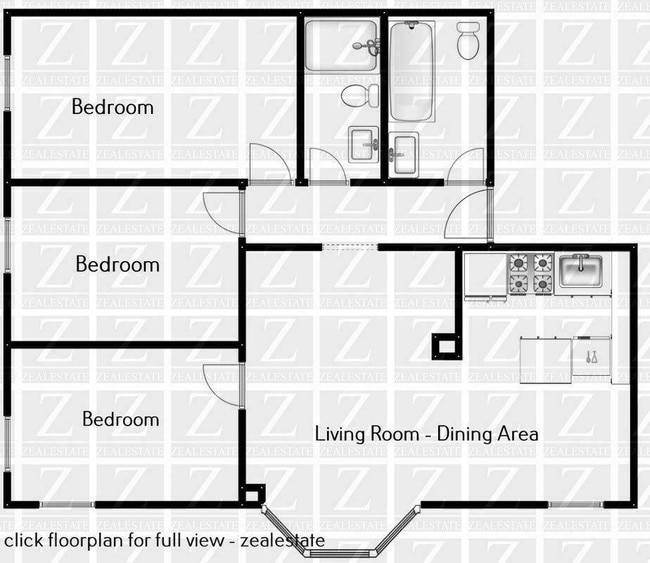
| Beds | Baths | Average SF |
|---|---|---|
| 3 Bedrooms 3 Bedrooms 3 Br | 2 Baths 2 Baths 2 Ba | 1,100 SF |
Fees and Policies
The fees listed below are community-provided and may exclude utilities or add-ons. All payments are made directly to the property and are non-refundable unless otherwise specified.
- Dogs Allowed
-
Fees not specified
- Cats Allowed
-
Fees not specified
About This Property
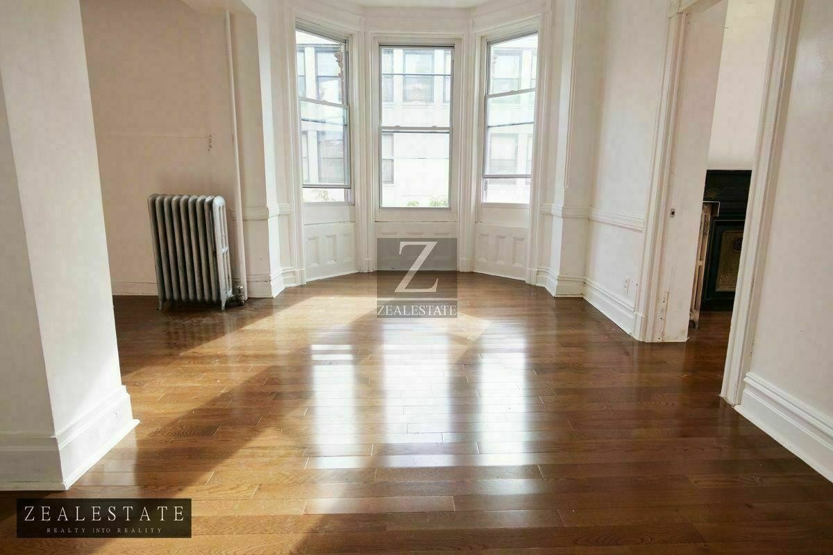
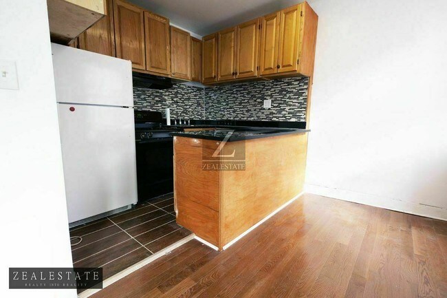
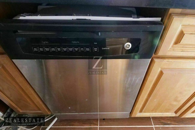
VIDEO TOUR copy and paste link, https://youtu.be/peC-QqLwEBOERUM HILL / PARK SLOPE NORTH3 Separate Bedrooms, all with closets and windows2 full size bathroomsDISHWASHER3rd floor walk up (no elevator)ROOF ACCESSEat In Kitchen with windowsLarge Living RoomWindows in every roomOriginal DetailsHigh CeilingsHEAT and HOT WATER is IncludedPETS ALLOWEDless than 5 minute walk to all trains at Atlantic Terminal, Close to all Bars, Caf's, Restaurants, Shopping and Transportation, Barclay's center.
303 Dean St is a townhome located in Kings County and the 11217 ZIP Code. This area is served by the New York City Geographic District #15 attendance zone.
Townhome Features
- Dishwasher
303 Dean St,
Brooklyn,
NY
11217
Located in northwestern Brooklyn, just south of downtown, Boerum Hill offers the serenity of a suburb and the excitement of a bustling urban environment. Residents enjoy access to a host of eclectic restaurants and unique shops strewn along the main commercial thoroughfares—Smith Street and Atlantic Avenue.
In more residential parts of the neighborhood, historic brownstones and townhouses nestle up to quiet, tree-lined streets. Boerum Hill has two sister neighborhoods, Cobble Hill and Carol Gardens, which are both situated west of Boerum Hill. The iconic Barclays Center lies just east of Boerum Hill, hosting exciting events like Brooklyn Nets basketball games, boxing matches, and concerts. Convenient subway access makes getting around from Boerum Hill easy.
Learn more about living in Boerum HillBelow are rent ranges for similar nearby apartments
Amenities
- Dishwasher
Education
| Colleges & Universities | Distance | ||
|---|---|---|---|
| Colleges & Universities | Distance | ||
| Walk: | 10 min | 0.6 mi | |
| Walk: | 14 min | 0.7 mi | |
| Walk: | 16 min | 0.9 mi | |
| Drive: | 4 min | 1.2 mi |
303 Dean St is within 10 minutes or 0.6 mile from Long Island Univ., Brooklyn. It is also near ASA College Brooklyn and Brooklyn Law School.
Schools


Public Elementary School
Grades PK-5
547 Students
Attendance Zone
Public Middle School
Grades 6-8
522 Students
Nearby
Public High School
Grades 9-12
891 Students
Nearby
Private Elementary & Middle School
Grades PK-8
Nearby
Private Elementary School
Grades PK-5
105 Students
Nearby
Private High School
Grades 9-12
276 Students
Nearby
School data provided by
 The GreatSchools Rating helps parents compare schools within a state based on a variety of school quality indicators and provides a helpful picture of how effectively each school serves all of its students. Ratings are on a scale of 1 (below average) to 10 (above average) and can include test scores, college readiness, academic progress, advanced courses, equity, discipline and attendance data. We also advise parents to visit schools, consider other information on school performance and programs, and consider family needs as part of the school selection process.
View GreatSchools Rating Methodology
Data provided by GreatSchools.org © 2026. All rights reserved.
View GreatSchools Rating Methodology
Data provided by GreatSchools.org © 2026. All rights reserved.
Transportation options available in Brooklyn include Pacific Street, located 0.2 mile from 303 Dean St. 303 Dean St is near LaGuardia, located 10.6 miles or 21 minutes away, and Newark Liberty International, located 15.3 miles or 27 minutes away.
| Transit / Subway | Distance | ||
|---|---|---|---|
| Transit / Subway | Distance | ||
|
|
Walk: | 3 min | 0.2 mi |
|
|
Walk: | 6 min | 0.3 mi |
|
|
Walk: | 6 min | 0.4 mi |
|
|
Walk: | 8 min | 0.4 mi |
|
|
Walk: | 9 min | 0.5 mi |
| Commuter Rail | Distance | ||
|---|---|---|---|
| Commuter Rail | Distance | ||
|
|
Walk: | 7 min | 0.4 mi |
|
|
Drive: | 6 min | 1.9 mi |
|
|
Drive: | 13 min | 4.3 mi |
|
|
Drive: | 13 min | 4.4 mi |
|
|
Drive: | 19 min | 7.0 mi |
| Airports | Distance | ||
|---|---|---|---|
| Airports | Distance | ||
|
LaGuardia
|
Drive: | 21 min | 10.6 mi |
|
Newark Liberty International
|
Drive: | 27 min | 15.3 mi |
Walkability Near 303 Dean St Brooklyn, NY 11217
Getting Around
 What do Walkability, Transit, Drivability, and Bikeability mean?
Walkability measures the walking distance to day-to-day needs.
Transit measures access to public transportation.
Drivability measures congestion, parking availability, and access to major roads.
Bikeability measures the suitability for cycling.
How It Works
What do Walkability, Transit, Drivability, and Bikeability mean?
Walkability measures the walking distance to day-to-day needs.
Transit measures access to public transportation.
Drivability measures congestion, parking availability, and access to major roads.
Bikeability measures the suitability for cycling.
How It Works
Exceptionally Walkable
Walkability
100
/ 100
Exceptional Public Transit
Transit
100
/ 100
Fairly Drivable
Drivability
40
/ 100
Moderately Bikeable
Bikeability
70
/ 100
Scores provided by
-
Soundscore™
-
/ 100
Traffic
-Airport
-Businesses
-Scores provided by
HowLoud What is a Sound Score Rating? A Sound Score Rating aggregates noise caused by vehicle traffic, airplane traffic and local sources. How It WorksTime and distance from 303 Dean St.
| Shopping Centers | Distance | ||
|---|---|---|---|
| Shopping Centers | Distance | ||
| Walk: | 10 min | 0.5 mi | |
| Drive: | 5 min | 1.8 mi |
303 Dean St has 2 shopping centers within 1.8 miles, which is about a 5-minute drive. The miles and minutes will be for the farthest away property.
| Parks and Recreation | Distance | ||
|---|---|---|---|
| Parks and Recreation | Distance | ||
|
Cobble Hill Park
|
Walk: | 17 min | 0.9 mi |
|
Gowanus Canal
|
Walk: | 18 min | 0.9 mi |
|
Fort Greene Park
|
Drive: | 4 min | 1.2 mi |
|
Cadman Plaza Park
|
Drive: | 4 min | 1.4 mi |
|
Commodore Barry Park
|
Drive: | 5 min | 1.6 mi |
303 Dean St has 5 parks within 1.6 miles, including Fort Greene Park, Cobble Hill Park, and Gowanus Canal.
| Hospitals | Distance | ||
|---|---|---|---|
| Hospitals | Distance | ||
| Walk: | 10 min | 0.6 mi | |
| Drive: | 5 min | 1.8 mi | |
| Drive: | 8 min | 2.6 mi |
303 Dean St has 3 hospitals within 2.6 miles, the nearest is Brooklyn Hospital Center - Downtown Campus which is 0.6 mile away and a 10 minute walk.
| Military Bases | Distance | ||
|---|---|---|---|
| Military Bases | Distance | ||
| Drive: | 12 min | 5.5 mi | |
| Drive: | 14 min | 6.5 mi | |
| Drive: | 25 min | 12.6 mi |
303 Dean St has 3 military bases within 12.6 miles, the nearest is Governors Island Support Center which is 5.5 miles away and a 12 minute drive.
You May Also Like
Similar Rentals Nearby


What Are Walk Score®, Transit Score®, and Bike Score® Ratings?
Walk Score® measures the walkability of any address. Transit Score® measures access to public transit. Bike Score® measures the bikeability of any address.
What is a Sound Score Rating?
A Sound Score Rating aggregates noise caused by vehicle traffic, airplane traffic and local sources.

303 Dean St
Brooklyn, NY 11217